LCT 14: River Valleys
Landscape character type summary
Where the Thames passes south through the chalk downlands and then eastwards to the south of the Chilterns, and where it cuts northwards through the Midvale Ridge, the landforms are characterised as River Valleys, distinct from the broader Vales. River Valleys are also defined along a stretch of the River Thame and where there is a cut through the Midvale Ridge between Botley and the River Thames alongside the Farmoor Reservoir.
Seven landscape character areas (LCA) are identified:
- LCA 14A: Farmoor Reservoir Lower Valley
- LCA 14B: Eynsham to Oxford Thames River Valley
- LCA 14C: Botley to Kennington Thames River Valley
- LCA 14D: Abingdon to Kennington Thames Lower Valley
- LCA 14E: River Thame Lower Valley
- LCA 14F: Moulsford to Caversham Thames Lower Valley
- LCA 14G: Caversham to Henley Thames Lower Valley
LCA 14A: Farmoor Reservoir Valley
It should be noted that the lines used to denote where LCAs border settlements are approximate and should not be used for planning purposes.
LCA 14A - View the map full screen in a new tab
Character Area Location
The LCA is located in the north of the Vale of White Horse district, on the district border with West Oxfordshire. The area is dominated by the Farmoor Reservoir, with the River Thames floodplain to the west along the district boundary. Land in the east is largely arable fields. The northern boundary is formed by the Ridge Hilltops (LCA 7B), and the southern boundary by the rising topography of the Vale Edge Slopes (LCA 9G).
Key characteristics
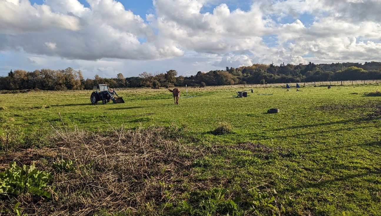
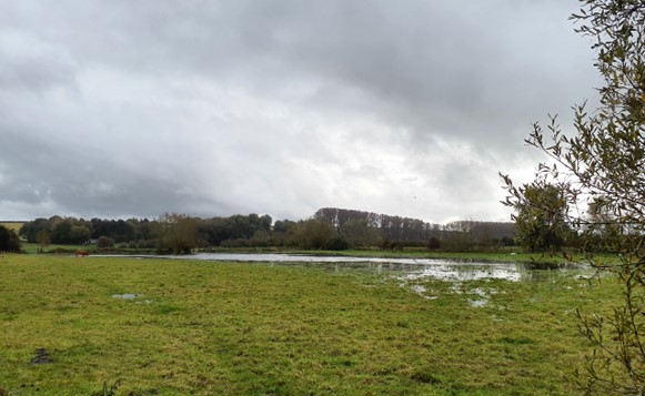
- A low-lying and generally flat landscape, which forms part of the River Thames floodplain. The underlying natural topography was altered at the western end of the valley by the construction of banks to form Farmoor Reservoir.
- The reservoir dominates the landscape, while land to the east comprises a series of large-scale arable fields.
- An internally open landscape with tree cover limited to riparian vegetation along the River Thames and small streams, small tree groups and a relatively intact network of field boundary hedgerows in the east.
- Settlement is limited to the 20th century village of Farmoor in the north-west and scattered historic farmsteads elsewhere. Small-scale recreational development and a water treatment works at Farmoor Reservoir are the main developments.
- Excellent recreational access, with the Thames Path National Trail along the river, and the Oxford Greenbelt Way Long Distance Path; the reservoir is a well-visited recreational resource, including for sailing, fishing, birdwatching and walking.
- Visually contained by the limestone wooded ridges to the north-east and south, and small belts of vegetation along the B4017, River Thames and around the reservoir.
- A generally rural area, although impacted locally by road noise. Electricity pylon routes are a visually detracting feature within the landscape.
Dominated by Farmoor Reservoir, used extensively for recreation:
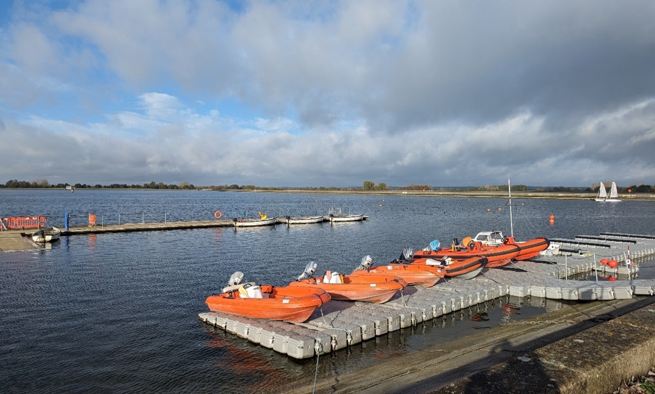
×![]()
Dominated by Farmoor Reservoir, used extensively for recreation:
Farmoor Reservoir with Wytham Hill in the background:
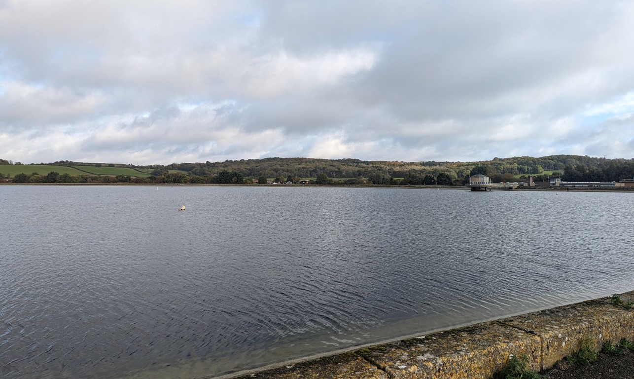
×![]()
Farmoor Reservoir with Wytham Hill in the background:
River Thames, crossed by pylons in the background:
×![]()
River Thames, crossed by pylons in the background:
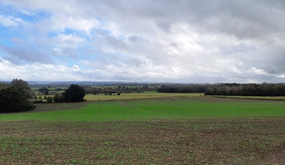
Open arable fields in the east with views to Wytham Woods:

×![]()
Open arable fields in the east with views to Wytham Woods:
Description
Natural (landform, water, semi-natural land cover)
- Underlain by Oxford Clay Formation and West Walton Formation mudstones.
- The valley falls from around 75 metres Above Ordnance Datum (AOD) on the edge of Botley down about 62 metres AOD on the eastern side of Farmoor Reservoir and along the River Thames. The natural topography has been altered by construction of the Farmoor Reservoir, with sloping sides raised above the surrounding ground level to around 65-70 metres AOD.
- The area immediately alongside the Thames edge, and the valley floor to the north and east of the reservoir, where a small tributary stream runs, are in Flood Zone 3.
- Pinkhill Meadow ponds were created on the eastern edge of the Thames in 1990 to trail ideas and concepts about river floodplain restoration, and there are now 40 ponds with a wealth of wetland plants. Recently the site has been used to experiment with the introduction of threatened Thames plant species such as Greater water-parsnip Sium latifolium.
- There are scattered tree groups and small woodlands including some identified as priority habitat deciduous woodland, but there are no significant areas of woodland. A relatively intact network of hedgerows along field boundaries in the east, and tree cover along the northern edge of the reservoir add to the semi-natural habitats.
Cultural/social (land use, settlement, infrastructure, historic character)
- and extended in 1976, with areas of pasture, meadow and scrub next to the Thames. The east generally comprises large-scale arable fields. with some smaller areas of pasture on the edges of development.
- The field pattern is identified as having a mixture of post-medieval and modern fieldscapes.
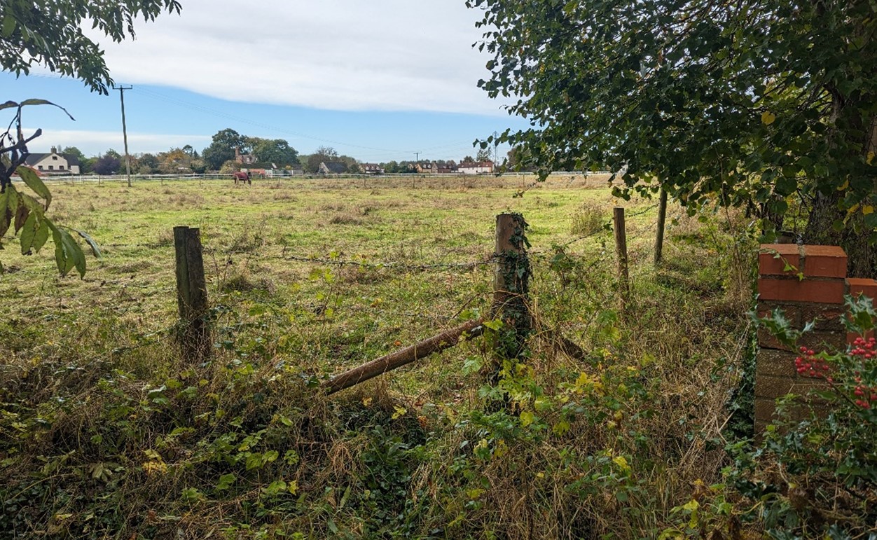
- Farmoor is an early 20th century village and is the only substantial settlement in the landscape. There are small, linear housing developments at Lower Whitley Road and Nobles Lane, and a few scattered farmsteads, some with listed farmhouses and associated barns. A small park home estate lies to the south of Nobles Farm close to the edge of Botley. Although not in keeping with the local vernacular or settlement pattern, it is well screen by vegetation and has little influence on the wider landscape.
- Development surrounding the reservoir includes a water treatment works and the Oxford sailing club buildings, boat storage and car parks to the east and north of the reservoir.
- Road access is limited internally to the B4017 and B4044. The A420 to the east, which defines the urban edge at Botley, is well-screened by vegetation.
- The Thames Path National Trail runs along the river corridor in the west and the Oxford Greenbelt Way long distance path runs through the south-east of the valley. These are connected by a network of local public rights of way.
- There are strong recreational opportunities at the reservoir including sailing, birdwatching and fishing. The Thames is navigable, and waterborne craft add activity and colour to the winding river course, including at Pinkhill Lock in the north-west.
Perceptual (views, tranquillity, associations)
- The valley is contained by hills to the north and south which form wooded backdrops on the horizon. The sloping banks and reflections of light on the water of the reservoir are prominent in views from elevated locations to the north and south, including from Cumnor Hill. The River Thames is largely hidden from view by riparian vegetation.
- There is a contrast between the naturalistic, rural meandering Thames corridor, which is screened by riparian vegetation, and the open, concrete-sided Farmoor Reservoir.
- Despite the proximity to the western edge of Botley, the presence of the town is largely obscured by vegetation along the A420. The valley’s arable fields provide a physical and visual gap between Farmoor and Botley.
- The electricity pylons and noise from traffic on the A420 and B4044 are detracting features, but there is a degree of peace and tranquillity along footpaths away from these features, with surrounding higher ground creating a sense of rural containment. The Tranquillity Assessment for South Oxfordshire and Vale of White Horse categorises 97% of the LCA in Zone 2 (‘areas of some tranquillity’).
- The landscape west of the Thames (outside of the district) is unsettled and highly rural, which provides a wider rural setting and lends a sense of peace and tranquillity to the western edges of the area.
Valued qualities
- Wetland habitats at Pinkhill Meadow ponds, mature hedgerows, riparian vegetation along the Thames and areas of deciduous woodland provide ecological value and contribute positively to the landscape.
- Smaller-scale fields, riparian vegetation and wetland habitats along the River Thames to the west result in rural, and naturalistic character and a greater sense of enclosure and intimacy.
- The sparse settlement pattern, large arable fields and wooded backdrop to the north and south create a rural sense of place with a degree of peace and tranquillity.
- The arable fields provide an open rural setting to Farmoor and Botley.
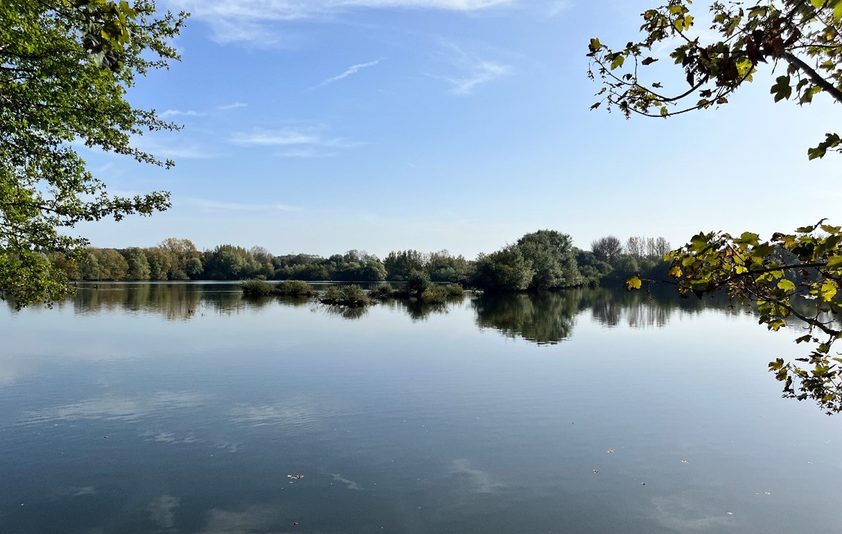
- Farmoor Reservoir is distinctive in being the largest single area of open water in Oxfordshire. It is prominent in views from higher ground to the north and south, and provides an important habitat for birds.
- Recreational value of the River Thames, Thames Path National Trail, the Oxford Greenbelt Way Long Distance Path and Farmoor Reservoir.
- The shallow valley-side slope to the north of the village of Farmoor forms part of the footslopes of Wytham Hill and so, along with the steeper and more wooded parts of the hill, is included within the West Oxford Hills Local Landscape Designation. The valley forms a visible part of the setting to both the West Oxford Hills and Northern Thames Valley Local Landscape Designations.
Forces for change
- Historic conversion of meadow and pasture fields to arable farming to the east, altering the characteristic river valley landscape.
- Poor maintenance and loss of field boundaries, resulting in some gaps in hedgerows. Loss of hedgerows would increase the sense of openness and may affect the more semi-enclosed character along to the river to the west.
- Threat of the spread of invasive species along the riverbanks, including Himalayan Balsam.
- Potential future pressure for increased development on the edges of Botley and Farmoor, which would affect the rural character and views across the landscape.
- The drive for Net Zero may increase pressure for solar developments in this landscape. This could affect the valley’s rural character and have an impact on views across the landscape, both locally and from higher ground.
- The River Valley landscapes may be susceptible to the impacts of climate change, including:
- Drier summers and wetter winters may lead to increased mortality and die-back of certain hedgerow tree species; an increased occurrence of insect pests and pathogens could lead to a potential loss or significant reduction in populations of key hedgerow tree species; and increased storm activity may lead to the loss of mature and veteran trees within hedgerows.
- Wetter winters may mean woody species in hedgerows are exposed to prolonged flooding in the growing season and will be at risk of dying, and winter trimming will become more difficult due to wet ground (preferred to autumn trimming to ensure food supply for birds).
- Intensification of adjacent land use leading to increased impacts on hedgerows such as pesticide drift and nutrient enrichment.
- Hotter drier summers and wetter winters and winter flooding could result in changes to wetland and riparian plant community composition; some non-native species may become invasive, and other currently geographically restricted species may spread more easily.
- Wetter winters and higher peak river flows may lead to increased flood defense activity, creating more physical habitat degradation and introducing potentially detracting features.
- Higher average temperatures and drier summers could lead to changes to community composition in arable field margins; an increase in bare ground and an increased risk of dieback in drought prone locations; the introduction of new crops and associated changes to management could alter the area and type of field margins; and an increase in agricultural use of summer insecticides which could reduce insect numbers and pollination.
- Hotter, drier summers and wetter winters will lead to changes in food production and growing seasons. Flooded land is only capable of supporting lower-value crops, pasture or woodland, which would impact important arable crops. Landscape appearance will likely also be altered, particularly if relocation of growing areas is required or crop diversification occurs (causing a need for changes in field pattern and the potential removal of field margins, hedgerows, woodlands).
Landscape strategy and guidelines
Retain existing woodland cover and look to increase this, particularly in open arable areas to the east, to provide ecological value and an increased sense of enclosure and help to limit the urbanising influence of development and busy roads.
- Explore opportunities to expand and connect existing woodland and tree cover through natural regeneration or small-scale planting. This will strengthen landscape character and bring benefits for biodiversity.
- Encourage the appropriate management of woodland, including to reduce the impacts of pests and diseases and to increase its age structure and structural heterogeneity. Consider the promotion of natural colonisation adjacent to existing woodland, allowing locally native species to develop resilience to the pressures of climate change through natural processes.
- Seek to prevent further loss or decline in the quality of boundary hedgerows and encourage their restoration/reinstatement; when establishing new hedges, aim to diversify the range of species and select species and provenances adapted to a wider range of climatic conditions.
- Use trees and woodland to integrate development into the landscape.
Retain and enhance the pastoral character along the Thames by strengthening the smaller-scale field pattern and conserving and enhancing areas of wetland and riparian habitats and the ecological value they provide. Consider opportunities to enhance the ecological value and appearance of intensively farmed arable land in the valley.
- Conserve and enhance the pattern of ponds, mature hedgerows and riparian vegetation along the river, to enhance their contribution to landscape character and their nature conservation value.
- Explore opportunities to expand and connect these habitats into the currently intensively managed arable land to the east to enhance the river valley character.
- Encourage adjacent land uses which strengthen role as ecological corridors and enhance landscape character.
- Seek opportunities to enhance connectivity with other habitats nearby, including the woodlands of Wytham Hill, by creating green corridors and networks.
- Manage arable land to enhance its biodiversity value and connectivity, by maintaining and expanding the area of land available for uncultivated arable field margins; seek to maximise the diversity of margins to provide a range of habitats and to assist in the movement of species through the landscape and include species and cultivars that are able to tolerate and flower under hotter, drier summers.
Maintain the open character and recreational value of the landscape, which provides access and a rural setting to the settlements of Farmoor and Botley.
- Minimise the impact of any new development on local character and on views from adjacent higher ground.
- Ensure any new development does not detract from the historic farmsteads and associated barns. Encourage the use of local materials.
- Consider the impact of lighting on night-time views (refer to the guidance in the Dark Skies Assessment for South Oxfordshire and Vale of White Horse).
- Refer to the South Oxfordshire and Vale of White Horse Renewable Energy Study when considering any solar panel applications. Consider the impact on views of the solar arrays from the surrounding higher ground.
- Protect and manage the valued recreational use of the landscape on public rights of way, particularly along promoted routes, and at Farmoor Reservoir. Consider opportunities to improve public right of way connections, infrastructure and signage.
LCA 14B: Eynsham to Oxford Thames River Valley
It should be noted that the lines used to denote where LCAs border settlements are approximate and should not be used for planning purposes.
LCA 14B - View the map full screen in a new tab
Character Area Location
The LCA covers the Thames River Valley which loops around the east, north and west sides of Wytham Hill (LCA 7B). The river valley/vale and floodplain continue to the north, east and west across administrative boundaries into West Oxfordshire, Cherwell and Oxford.
Key characteristics
- A predominantly flat, low-lying landscape forming part of the River Thames floodplain; crossed by the Wytham Stream/Seacourt Stream tributary and other small tributaries of the Thames. The Thames itself is a distinctive landscape element forming the district boundary to the north and west.
- An open landscape with limited tree cover, which contrasts with the wooded backdrop provided by Wytham Hill, the slopes of which rise steeply from the valley floor.
- Wytham Ditches and Flushes Site of Special Scientific Interest supports species-rich eutrophic aquatic and fen flora, now rare in Oxfordshire, as well as distinctive areas of floodplain grazing marsh.
- Pasture fields dominate the landscape, some of which are relatively large with significant gaps in boundary vegetation. Smaller areas of rough grass enclosed by tree cover are found on the footslopes of Wytham Hill.
- Settlement is limited to the historic village of Wytham, located on the Seacourt Stream/Wytham Stream; the wider floodplain forms part of its rural setting, with some long views across the floodplain.
- Limited road access to the area, although recreational access is provided by the Thames Path and Oxford Greenbelt Way.
- A rural landscape, with the elevated A34 the only detractor; traffic is sometimes visible through gaps in the vegetation.
Flat floodplain backdropped by Wytham Hill:
×![]()
Flat floodplain backdropped by Wytham Hill:
Grazing cattle on the floodplain near Wytham:
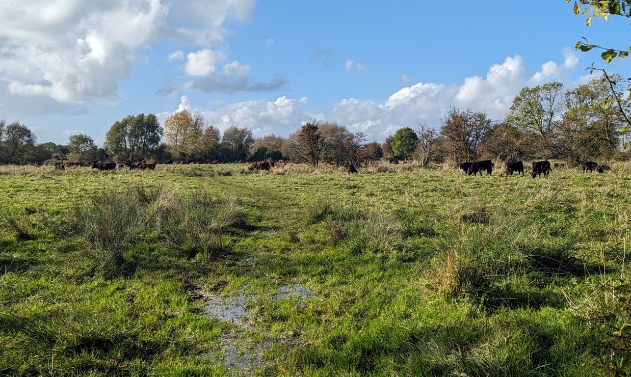
×![]()
Grazing cattle on the floodplain near Wytham:
Limestone vernacular in Wytham:
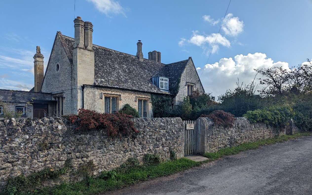
×![]()
Limestone vernacular in Wytham:
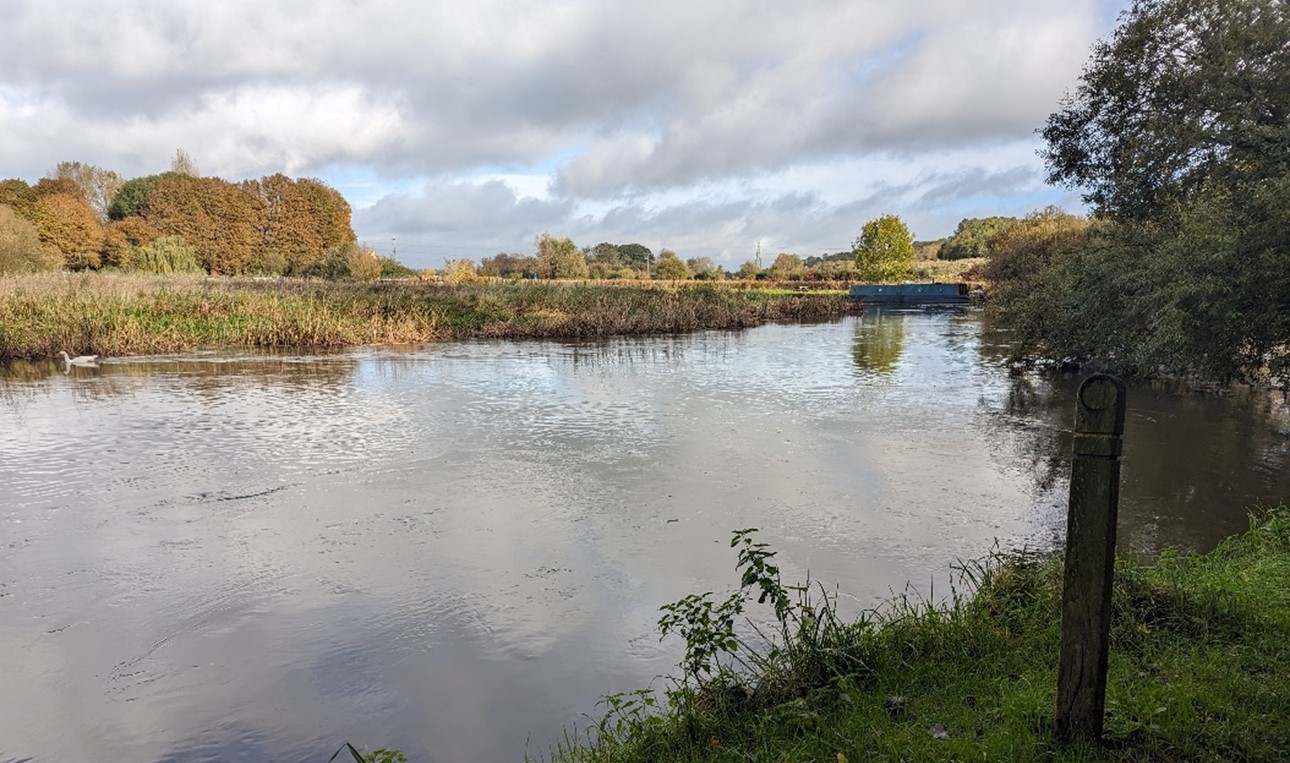
River Thames at Swinford Bridge:

×![]()
River Thames at Swinford Bridge:
Description
Natural (landform, water, semi-natural land cover)
- Underlain by Oxford Clay Formation and West Walton Formation mudstones, with considerable alluvium and gravel superficial deposits.
- The Thames floodplain is very flat, sitting at 60 metres Above Ordnance Datum (AOD). The western / north-western slopes of Wytham Hill rise steeply from the Thames, so the area characterised as River Valley is very narrow. Further east, in the vicinity of the village of Wytham, the more gentle, lower footslopes of the hill, up to around 75 metres AOD, are characterised as part of the River Valley.
- The River Thames forms the district boundary to the north and west.. Wytham Stream/Seacourt Stream and other small tributaries of the Thames cross the east of the area, before joining the Thames in Oxford. The majority of the area is covered by Flood Zones 2 and 3.
- Wytham Ditches and Flushes support species-rich eutrophic aquatic and fen flora, now rare in Oxfordshire, as well as priority habitat floodplain grazing marsh. The ditches are nationally designated as a Site of Special Scientific Interest (SSSI). Elsewhere mature riparian trees and shrubs along the banks of the Thames, and priority habitat lowland meadow south of Wytham and in the west near Swinford Farm contribute to natural heritage.
Cultural/social (land use, settlement, infrastructure, historic character)
- Pasture fields dominate the landscape, some of which are relatively large with significant gaps in boundary vegetation. Smaller areas of rough grass enclosed by tree cover are found on the footslopes of Wytham Hill.
- Wytham is located at the foot of Wytham Hill, and the John Krebs Field Station University Farm, part of Oxford University, lies to the north of the village. The village has a linear form, with a historic nucleus around Wytham Abbey and church, and is covered by a Conservation Area, with a strong vernacular of limestone and some thatched roofs. Wytham Abbey, a Grade I Listed Building, was built in the 15th and 16th centuries, and remodelled in the 19th century for the Earl of Abingdon.
- Outside of Wytham, settlement on the floodplain is limited, with a few dwellings associated with Swinford Farm (some Grade II Listed Buildings), where the Swinford toll bridge (Scheduled Monument) carries the B4044 across the Thames. The remains of Seacourt medieval settlement are located in the south-east, where the hollow ways or streets can be seen. The village declined during the Middle Ages due to the expansion of Oxford, and its earthworks are now a Scheduled Monument (which extends to the east of the A34).
- Road access is limited to the B4044 in the west, which marks the edge of the floodplain, and minor roads in the east connecting Wytham across the floodplain. In contrast, the A34 is elevated above the east of the floodplain and is a busy road. The A420 and an adjacent tree belt form a strong boundary to Botley, although there is some remaining open land between the urban edge and the main road.
- The Thames Path National Trail allows access alongside the river, while the Oxford Greenbelt Way Long Distance Path connects Swinford and Wytham. The Thames is navigable and provides an important recreational facility.
Perceptual (views, tranquillity, associations)
- The open character of the flat Thames floodplain contrasts with the dramatic wooded backdrop provided by Wytham Hill. Views across the floodplain to the wooded hills are noted as important in the Wytham Conservation Area Appraisal.
- The A34 dual carriageway, which marks the district boundary to the east, is elevated above the floodplain and road traffic is visible through gaps in the roadside vegetation. Other human influences include the occasional views of settlement and the university field station. The Tranquillity Assessment for South Oxfordshire and Vale of White Horse categorises 93% of the LCA in Zone 2 (‘areas of some tranquillity’).
Valued qualities
- The floodplain landscape contains nationally important wetland and fen habitats at Wytham Ditches and Flushes SSSI, which along with riparian habitats along the River Thames and Wytham Stream/Seacourt Stream provide ecological value and contribute positively to the landscape.
- Pastoral land use and a limited road network internally creates a strong rural landscape.
- The open views across the flat floodplain contrast with the wooded backdrop of Wytham Hill, which provides a sense of containment and a sense of place.
- Wytham is a historic village which benefits from its open floodplain setting and provides time depth within the landscape. The views across the floodplain to the wooded backdrop of Wytham Hill are noted as important in the Wytham Conservation Area Appraisal.
- Time-depth and historic character also provided by the presence of Seacourt medieval settlement (Scheduled Monument) to the south.
- Recreational value of the Thames Path National Trail, Oxford Greenbelt Way long distance path and River Thames.
- The value of the landscape is demonstrated by its inclusion within the West Oxford Hills Local Landscape Designation.
Forces for change
- Poor maintenance and loss of field boundaries, resulting in gaps in hedgerows. This affects the structure of the landscape and causes an increased sense of openness.
- Historic conversion of meadow and pasture fields to arable farming, altering the characteristic river valley landscape.
- Pressure for increased development on the edge of Botley to the south, although the A420 and adjacent woodland belt form a strong boundary to all but the southernmost fringe of the valley side.
- The River Valley landscapes may be susceptible to the impacts of climate change, including:
- Deciduous woodlands are facing decline due to warmer winters, altered rainfall patterns, drier summers and increased frequency of extreme events; there may be a shift in vegetation type and composition, increased competition from invasive species, greater numbers of insect and mammal pests, a greater risk of infection by various soil and water-borne pathogens, and a greater risk of wind-throw and loss of mature trees.
- Drier summers and wetter winters may lead to increased mortality and die-back of certain hedgerow tree species; an increased occurrence of insect pests and pathogens could lead to a potential loss or significant reduction in populations of key hedgerow tree species; and increased storm activity may lead to the loss of mature and veteran trees within hedgerows.
- Wetter winters may mean woody species in hedgerows are exposed to prolonged flooding in the growing season and will be at risk of dying, and winter trimming will become more difficult due to wet ground (preferred to autumn trimming to ensure food supply for birds).
- Hotter drier summers and wetter winters and winter flooding could result in changes to wetland and riparian plant community composition; some non-native species may become invasive, and other currently geographically restricted species may spread more easily.
- Wetter winters and higher peak river flows may lead to increased flood defence activity, creating more physical habitat degradation and introducing potentially detracting features.
- Hotter, drier summers and wetter winters will lead to changes in food production and growing seasons. Flooded land is only capable of supporting lower-value crops, pasture or woodland, which would impact important arable crops. Landscape appearance will likely also be altered, particularly if relocation of growing areas is required or crop diversification occurs (causing a need for changes in field pattern and the potential removal of field margins, hedgerows, woodlands).
Landscape strategy and guidelines
Retain the pastoral character of the landscape by enhancing areas of wetland and riparian habitats and the ecological value they provide.
- Conserve and manage the wetland and fen flora at Wytham Ditches and Flushes SSSI to improve landscape character and encourage biodiversity.
- Conserve and enhance the pattern of floodplain grazing marsh, lowland meadow and riparian vegetation along the river, to enhance their contribution to landscape character and their nature conservation value.
- Encourage adjacent land uses which strengthen role as ecological corridors and enhance landscape character.
- Seek opportunities to enhance connectivity with other habitats nearby by creating green corridors and networks, including the woodland of Wytham Woods.
Retain existing woodland cover and look to increase this, to provide ecological value and to help limit the urbanising influence of development and busy roads to the south.
- Explore opportunities to expand and connect existing woodland and tree cover through natural regeneration or small-scale planting. This will strengthen landscape character and bring benefits for biodiversity.
- Encourage the appropriate management of woodland, including to reduce the impacts of pests and diseases and to increase its age structure and structural heterogeneity. Consider the promotion of natural colonisation adjacent to existing woodland, allowing locally native species to develop resilience to the pressures of climate change through natural processes.
- Seek to prevent further loss or decline in the quality of boundary hedgerows and encourage their restoration/reinstatement; when establishing new hedges, aim to diversify the range of species and select species and provenances adapted to a wider range of climatic conditions.
- Use trees and woodland to integrate development into the landscape.
Maintain the open character and recreational value of the landscape, which provides access and a rural setting to the historic village of Wytham and nationally important heritage features. Protect characteristic views across the landscape and outwards.
- Minimise the impact of any new development on local character and on views from adjacent higher ground.
- Retain the settlement pattern concentrated at Wytham, with only occasional houses outside of the village. Use materials which are in keeping with, or complement, the local vernacular of limestone and thatched roofs.
- Consider the impact of lighting on night-time views (refer to the guidance in the Dark Skies Assessment for South Oxfordshire and Vale of White Horse).
- Protect and manage the valued recreational use of the landscape on public rights of way. Consider opportunities to improve public right of way connections, infrastructure and signage.
- Respect the setting to Wytham Conservation Area, including the important view across the floodplain to Wytham Hill, and the sensitivity of historic settlement edges, by resisting changes to the landscape which are not in keeping with the landscape character, including unsympathetic housing developments.
- Protect and where possible enhance characteristic views across the floodplain to the wooded backdrop of Wytham Hill.
- Maintain the open setting of Seacourt Medieval settlement (Scheduled Monument), by resisting changes to the landscape which are not in keeping with the landscape character.
LCA 14C: Botley to Kennington Thames River Valley
It should be noted that the lines used to denote where LCAs border settlements are approximate and should not be used for planning purposes.
LCA 14C - View the map full screen in a new tab
Character Area Summary and Location
The LCA covers the Thames River Valley and its associated channels, including the Hinksey Stream. It lies between Botley and Kennington, straddling the Vale of White Horse and South Oxfordshire districts. The area comprises a flat floodplain landscape, largely in pasture use, and is heavily influenced by the A34 and A423, and proximity to large urban areas. It is backdropped by steep wooded hills to the west (LCA 7B). In the north-east the floodplain and tributary streams of the Thames continue east across the administrative boundary into Oxford.
Key characteristics
- Flat floodplain landscape of the River Thames, and its associated channels Hogacre Ditch, Hinksey Stream and Littlemore Brook.
- Extensive areas of distinctive wetland habitats, including lowland meadows and floodplain grazing marsh, with many areas of pasture managed for conservation. This includes Iffley Meadows Site of Special Scientific Interest, designated for its rich grassland flora.
- Riparian woodland, hedgerows, small tree groups and plantations create a sense of significant tree cover.
- Pasture and arable fields drained by ditches, with varying boundary vegetation including hedgerows and mature hedgerow trees along the river corridors; some larger-scale arable fields around Sandford-on-Thames.
- Settlement is limited to small historic villages of South Hinksey and Sandford-on-Thames; however, the larger settlements of Kennington, North Hinksey and Oxford itself lie adjacent to the River Valley.
- Tree cover provides some screening, but tranquillity and rurality are significantly impacted by major road and rail infrastructure, electricity pylon routes and proximity to urban areas. The A34, A4074, A423 and Cherwell Valley railway line all border the urban edges, and both the A423 and the railway line cross it, through the narrow gap between Kennington and the edge of Oxford at New Hinksey. These routes are generally well-screened from view but are an aural detractor.
- Good recreational access including the Thames Path National Trail, Shakespeare’s Way, National Cycling Route 5 and recreation on and in the Thames itself; the A34 and Cherwell Valley railway partially sever east-west movement across the landscape.
- The wooded ridge west of Kennington provides a distinctive backdrop to many views. Layers of vegetation provide some screening, including to the settlement edges of Kennington and Botley, as well as the A34 and railway line.
River Thames with strong riparian vegetation, near Rose Isle:
×![]()
River Thames with strong riparian vegetation, near Rose Isle:
Arable field with electricity pylons (South Hinksey):

×![]()
Arable field with electricity pylons (South Hinksey):
Functional floodplain at South Hinksey, with views to Oxford:
×![]()
Functional floodplain at South Hinksey, with views to Oxford:
Pasture fields in use for horse grazing at South Hinksey, with the well-wooded A34 behind:
×![]()
Pasture fields in use for horse grazing at South Hinksey, with the well-wooded A34 behind:
Description
Natural (landform, water, semi-natural land cover)
- Oxford Clay Formation and West Walton Formation mudstones, overlain by alluvium deposits along the river corridors and small areas of gravels.
- This area is the floodplain of the River Thames, and its associated channels the Hogacre Ditch, Hinksey Stream and Littlemore Brook. The floodplain lies around 55 metres Above Ordnance Datum (AOD) in the vicinity of Botley, falling to around 52 metres AOD at Sandford. The valley floor rises only gently in most places, although small areas of steeper valley-side strongly associated with the urban edges at North Hinksey and Kennington are included.
- North of the A423 the Thames forms the administrative boundary with Oxford. The River Thames is controlled by weirs and locks around Sandford-on-Thames.
- Extensive wetland habitats including priority habitat lowland meadows and floodplain grazing marsh. Many meadows are managed for conservation by the Oxford Preservation Trust. Iffley Meadows, a series of alluvial flood meadows managed as hay meadow and permanent pasture, are designated as a Site of Special Scientific Interest (SSSI) for the rich grassland flora, including rare fritillaries.
- Riparian woodland and small areas of priority habitat deciduous woodland are found around the major road network and settlements. Hedgerows, mature hedgerow trees, small tree groups and plantations add to a sense of significant tree cover.
Cultural/social (land use, settlement, infrastructure, historic character
- varying boundary vegetation including hedgerows and mature hedgerow trees along the river corridors. There are some larger-scale arable fields around Sandford-on-Thames.
- Settlement in the lower valley is limited to the small villages of Sandford-on-Thames and South Hinksey, with several scattered farmsteads and isolated properties, but the larger settlements of North Hinksey, Kennington and Oxford lie on adjacent higher ground.
- Sandford-on-Thames, which was mentioned in the Domesday book, and South Hinksey, both contain important listed buildings including the Grade II* Listed churches of St Andrew and St Lawrence respectively.
- North Hinksey lies directly north, and the landscape provides a rural setting to the historic village and its Conservation Area.
- The valley is a significant transport corridor. The Cherwell Valley railway line, A34, A423 and A4074 define the principal urban edges along the valley sides, with the A423 and railway line bisecting the valley in the narrow gap between Kennington and the edge of Oxford at New Hinksey These features limit east-west movement across the landscape.
- Elsewhere road access is limited to local roads which retain a minor, rural character.
- Other infrastructure within the area includes Sandford hydro, a system of three Archimedes screws to generate electricity from the flow of the river and an associated fish pass.
- The Thames Path National Trail follows the route of the Thames, and Shakespeare’s Way runs through Sandford-on-Thames. There are pedestrian river crossings in several locations, including a link from South Hinksey village to New Hinksey. National Cycling Route 5 runs alongside the railway line at Kennington and connects into Oxford. Recreational opportunities are also afforded on the Thames including rowing and boating, while the pool under Sandford lock is a popular swimming spot.
Perceptual (views, tranquillity, associations)
- the settlement edges of Kennington and Botley. The wooded hills to the west of Oxford (LCA 7B) provide a wooded backdrop to many views.
- The river corridors are generally screened by vegetation from views away from their immediate vicinity, and they are not strong features within the landscape.
- Although often screened by tree cover, the A34, A423 and A4074 are a constant aural presence within the landscape, and significantly reduce any feeling of remoteness or tranquillity. A number of electricity pylon routes are modern features in many views. The Tranquillity Assessment for South Oxfordshire and Vale of White Horse categorises 27% of the LCA in Zone 2 (‘areas of some tranquillity’) and 70% in Zone 4 (‘areas of low tranquillity’).
- Proximity to larger settlements at Oxford, Kennington and Botley and lighting at the A34 roundabouts introduce light pollution. This is the only area categorised in the Dark Skies Assessment for South Oxfordshire and Vale of White Horse as having no land within the darkest two bands.
Valued qualities
- Wetland habitats, including at Iffley Meadows SSSI, and meadows, riparian vegetation along the river courses, provide ecological value and contribute positively to landscape character.
- Woodland blocks, riparian woodland, hedgerows, small plantations and roadside vegetation combine to create a strongly treed landscape, creating an enclosed character.
- The limited settlement pattern, and extensive pasture fields create a rural sense of place, despite proximity to urban areas and transport routes, with a continuation of historic land practices.
- Undeveloped landscape forms gaps between the various settlements, helping to retain their individual identities, and provides an open rural.
- The historic settlements at South Hinksey and Sandford-on-Thames provide time-depth.
- Strong recreational value along the Thames Path National Trail, and local cycling and walking routes. Water-based recreation on the Thames itself is also highly valued.
Forces for change
- Historic conversion of meadow and pasture fields to arable farming, altering the characteristic river valley character of the landscape.
- Poor maintenance and loss of field boundaries, resulting in gaps in hedgerows. Loss of hedgerows would increase the sense of openness and may affect the semi-enclosed character along to the river.
- Pressure for increased development on the edges of Botley, Kennington and Oxford, which would affect the rural character and setting of these settlements.
- Recent introduction of university sports pitches and facilities immediately to the south-east of North Hinksey Village, affecting the rural setting of the village and its Conservation Area.
- The River Valley landscapes may be susceptible to the impacts of climate change, including:
- Deciduous woodlands are facing decline due to warmer winters, altered rainfall patterns, drier summers and increased frequency of extreme events; there may be a shift in vegetation type and composition, increased competition from invasive species, greater numbers of insect and mammal pests, a greater risk of infection by various soil and water-borne pathogens, and a greater risk of wind-throw and loss of mature trees.
- Drier summers and wetter winters may lead to increased mortality and die-back of certain hedgerow tree species; an increased occurrence of insect pests and pathogens could lead to a potential loss or significant reduction in populations of key hedgerow tree species; and increased storm activity may lead to the loss of mature and veteran trees within hedgerows.
- Wetter winters may mean woody species in hedgerows are exposed to prolonged flooding in the growing season and will be at risk of dying, and winter trimming will become more difficult due to wet ground (preferred to autumn trimming to ensure food supply for birds).
- Intensification of adjacent land use leading to increased impacts on hedgerows such as pesticide drift and nutrient enrichment.
- Hotter drier summers and wetter winters and winter flooding could result in changes to wetland and riparian plant community composition; some non-native species may become invasive, and other currently geographically restricted species may spread more easily.
- Wetter winters and higher peak river flows may lead to increased flood defence activity, creating more physical habitat degradation and introducing potentially detracting features.
- Higher average temperatures and drier summers could lead to changes to community composition in arable field margins; an increase in bare ground and an increased risk of dieback in drought prone locations; the introduction of new crops and associated changes to management could alter the area and type of field margins; and an increase in agricultural use of summer insecticides which could reduce insect numbers and pollination.
Landscape strategy and guidelines
Retain the pastoral character of the landscape by enhancing areas of wetland and riparian habitats and the ecological value they provide.
- Conserve and manage the hay meadow and permanent pasture at Iffley Meadows SSSI to improve landscape character and encourage biodiversity.
- Conserve and enhance the pattern of floodplain grazing marsh, lowland meadow and riparian vegetation along the river, to enhance their contribution to landscape character and their nature conservation value.
- Encourage adjacent land uses which strengthen role as ecological corridors and enhance landscape character.
- Seek opportunities to enhance connectivity with other habitats nearby by creating green corridors and networks, including across the A34 to join the wooded ridge.
Retain existing woodland cover and look to increase this, to provide ecological value, enhance the sense of enclosure and to help limit the urbanising influence of development and busy roads.
- Retain and enhance woodland blocks and tree lines to improve landscape character and encourage biodiversity.
- Explore opportunities to expand and connect existing woodland and tree cover through natural regeneration or small-scale planting. This will strengthen landscape character and bring benefits for biodiversity.
- Encourage the appropriate management of woodland, including to reduce the impacts of pests and diseases and to increase its age structure and structural heterogeneity. Consider the promotion of natural colonisation adjacent to existing woodland, allowing locally native species to develop resilience to the pressures of climate change through natural processes.
- Seek to prevent further loss or decline in the quality of boundary hedgerows and encourage their restoration/reinstatement; when establishing new hedges, aim to diversify the range of species and select species and provenances adapted to a wider range of climatic conditions.
- Use trees and woodland to integrate development into the landscape.
Maintain the open character and recreational value of the landscape, which provides access and a rural setting to settlements, including the historic villages.
- Minimise the impact of any new development on local character and on views from adjacent higher ground.
- Respect the historic settlements at South Hinksey and Sandford-on-Thames, and the setting to North Hinksey Conservation Area. Retain areas of openness between the settlements, and ensure their distinct identities are retained.
- Retain the backdrop views to the wooded hills west of Oxford when planning any new development.
- Ensure any new development does not interrupt views across the floodplain from the higher ground to the west.
- Consider the impact of lighting on night-time views (refer to the guidance in the Dark Skies Assessment for South Oxfordshire and Vale of White Horse).
- Protect and manage the valued recreational use of the landscape and of public rights of way. Consider opportunities to improve public right of way connections, infrastructure and signage.
LCA 14D: Kennington to Abingdon Thames River Valley
It should be noted that the lines used to denote where LCAs border settlements are approximate and should not be used for planning purposes.
LCA 14D - View the map full screen in a new tab
Character Area Summary and Location
The LCA is located south of Kennington and east of Abingdon-on-Thames, across the boundary between Vale of White Horse and South Oxfordshire. It covers the River Thames and its floodplain, including flooded former quarry pits. The area has considerable areas of woodland, including steep wooded slopes in the south-east which are part of Nuneham Courtenay Registered Park and Garden. Wooded ridges to the east (LCA 7D) and west (LCA 7B) provide containment.
Key characteristics
- Flat low-lying floodplain landscape of the River Thames, enclosed by limestone ridges to the west and east.
- Riparian woodland and vegetation along the Thames often hide it from view within the landscape.
- Former mineral extraction has altered the landscape. Radley Lakes Nature Reserve, formed of flooded former gravel pits, supports a variety of flora and fauna, and several small areas of lowland meadow and floodplain grazing marsh are also a distinctive feature of the floodplain.
- Small-scale pasture fields line the river, with larger-scale arable fields and small areas of horticulture away from the river. Boundary vegetation varies: there are some shelterbelts and strong hedgerows but other areas with limited boundary vegetation.
- Abingdon lies on the lower valley side to the south-west, and Kennington sits on higher ground to the north-west. The village of Radley and adjacent college also lie on the western valley side.
- Localised detractors include quarrying activities, electricity pylon routes, roads on the fringes of the valley and the Cherwell Valley railway line, but few roads pass through the lower valley area, creating some sense of rural remoteness especially where vegetation adds visual enclosure
- Good levels of public access, with the Thames Path National Trail following the river, and the Oxford Greenbelt Way passing to the east of Radley. Water-based recreation along the Thames is common.
- Vegetation along the riverbank creates an enclosed character, with the River Thames often not visible. From more open areas views are available across the landscape with the rising limestone ridges to the east and west providing a wooded backdrop.
River Thames at Abingdon:

×![]()
River Thames at Abingdon:
Horse grazing at Lower Radley, with horse tape and post and wire fencing:
×![]()
Horse grazing at Lower Radley, with horse tape and post and wire fencing:
Cherwell Valley railway line lined by trees in backdrop of flat arable fields:

×![]()
Cherwell Valley railway line lined by trees in backdrop of flat arable fields:
Former gravel pits at Radley Lakes now managed for conservation and recreation:
×![]()
Former gravel pits at Radley Lakes now managed for conservation and recreation:
Description
Natural (landform, water, semi-natural land cover
- Predominately Ampthill Clay Formation and Kimmeridge Clay Formation mudstones, with a small area of limestone in the north. This is overlain by significant superficial deposits of alluvium along the course of the River Thames, and clay, silt, sand and gravel to the west of the river.
- A largely flat floodplain landscape lying between 55 and 65 metres Above Ordnance Datum (AOD). It is confined by rising limestone ridges to the west (LCA 7B) and east (LCA 7D).
- The landscape is shaped by the River Thames, although it is often not a dominant feature. Former gravel extraction pits at Radley Lakes are now largely water filled. Willow and poplar trees surround the old gravel pits, with some areas of priority habitat deciduous woodland. The area is now part of the Radley Lakes Local Nature Reserve. Small areas of priority habitat lowland meadow and floodplain grazing marsh are also found adjacent on the floodplain.
Cultural/social (land use, settlement, infrastructure, historic character)
- Riverside pasture fields with a riparian character and poor soils, and bounded by ditches, are used for grazing. Many of the pasture fields away from the river have been converted to horse grazing, with associated post and wire fencing and horse tape.
- The rest of the area comprises large-scale arable fields. Small-scale horticulture is located in the south-west, including fruit growing at Peach Croft Farm. There is a small area of ongoing gravel extraction south of Radley and a variety of business uses along Thrupp Lane resulting in movements of lorries along Thrupp Lane.
- Boundary vegetation varies: there are some shelterbelts and strong hedgerows but other areas with limited boundary vegetation.
- The field pattern is recorded as post-medieval and modern. Prehistoric ring-ditches and enclosures, and medieval ridge and furrow at Lower Farm, a possible Iron Age enclosed settlement east of Goose Acre Farm and Iron Age barrows north of Wick Hall demonstrate a rich time-depth in the landscape. These sites are all designated as Scheduled Monuments.
- The only settlement in the lower valley is Lower Radley, which contains a number of Listed Buildings, and isolated historic farmsteads. Wick Hall, a Grade II* Listed Building, retains a surrounding parkland character. Nuneham Courtenay Registered Park and Garden (RPG) and Conservation Area is predominately on higher ground (within LCA 7D) but extends down the eastern side of the valley to the River Thames.
- The south of the area lies adjacent to Abingdon, which developed at the confluence of the Ock and Thames. The 15th century bridge over the Thames still stands and is now designated as a Scheduled Monument. Trading wharves near St Helen’s church (Grade I Listed) once lined the Thames, and the floodplain still forms an important setting to the Abingdon Town Centre Conservation Area.
- Roads within the landscape are also limited, although the A4074 runs along the eastern boundary. The Cherwell Valley railway line also runs through the centre of the landscape.
- The Thames Path National Trail runs along the course of the river, and links to the Oxford Greenbelt Way which runs east of Radley. NCN 5 runs through the west of the area, partly along a disused railway, and there is informal recreation at Radley Lakes. Rowing and sailing are also popular activities along the River Thames. There is limited east-west connectivity.
Perceptual (views, tranquillity, associations)
- Boundary vegetation obscures and filters views of the adjacent urban edges of Radley, Kennington and Abingdon-on-Thames. Riparian vegetation along the River Thames often obscures views from the Thames Path to the river, creating an enclosed character.
- The River Thames is enlivened by the movement and colour of boats navigating the waterway.
- The rising ridge of Nuneham Courtenay forms a dramatic backdrop in views to the south-east. Blocks of woodland on the rising slopes of the Corallian limestone ridge also provide a backdrop to the west.
- Tree cover provides a degree of peace and relative tranquillity, and the agricultural land uses create a predominantly rural character. The quarry working has a limited impact on the relative tranquillity, although electricity pylon routes and noise from the A4074 in the east are detracting features. The Tranquillity Assessment for South Oxfordshire and Vale of White Horse categorises 79% of the LCA in Zone 2 (‘areas of some tranquillity’) and 11% in Zone 4 (‘areas of low tranquillity’).
- Proximity to larger settlements at Abingdon and Kennington introduces light pollution. Less than 50% of this landscape is categorised as within the darkest two bands in the Dark Skies Assessment for South Oxfordshire and Vale of White Horse.
Valued qualities
- Functional floodplain landscape, with riparian woodland and wetland habitats providing ecological value and contributing positively to the landscape.
- A rural and agricultural character, with a mixture of pasture, arable and horticultural land uses.
- Prehistoric and Iron Age settlements and burial mounds, designated as Scheduled Monuments, provide time-depth; the open landscape provides a setting to these features.
- Strong recreational access focussed on the River Thames.
- Provides an open rural riverside setting to the settlements of Radley, Abingdon and Kennington, including the Conservation Area at Abingdon.
- The landscape is important in retaining the sense of separation between settlements, particularly between Radley and Abingdon where the gap is quite narrow.
- Views are available across the landscape from more open areas, with the rising limestone ridges to the east and west often visible as a wooded backdrop.
- Vegetation along the river and floodplain, and limited settlement and road networks, create a sense of enclosure, peace and relative tranquillity in the lower valley floor area.
Forces for change
- Historic conversion of meadow and pasture fields to arable farming, altering the characteristic river valley character of the landscape.
- Poor maintenance and loss of field boundaries, resulting in some gaps in hedgerows. Loss of hedgerows would increase the sense of openness and may affect the more semi-enclosed character along to the river.
- Past and ongoing mineral extraction has altered the natural topography and characteristic land uses, and locally reduces tranquillity. There has been an intensification of business uses along Thrupp Lane, and an associated increase in vehicle movements, which is a cause for concern in relation to recreational use of this route by pedestrians and cyclists.
- Increase in horse grazing and associated facilities, changing the agricultural character.
- Recent and proposed introduction of solar farm developments in the nearby vales and the drive for Net Zero may increase pressure for solar developments in this landscape. This would change the traditional agricultural land use and have a localised impact on views across the landscape.
- Pressure for increased development on the edges of the landscape would affect the rural character, and views across the landscape. This landscape abuts a number of allocations, Kennington (including as part of the South Kennington Strategic Allocation), Radley (including as part of the North West Radley Strategic Allocation), Abingdon (including as part of the Abingdon Science Park Strategic Allocation, and Oxford (as part of the Land south of Grenoble Road Strategic Allocation).
- The River Valley landscapes may be susceptible to the impacts of climate change, including:
- Drier summers and wetter winters may lead to increased mortality and die-back of certain hedgerow tree species; an increased occurrence of insect pests and pathogens could lead to a potential loss or significant reduction in populations of key hedgerow tree species; and increased storm activity may lead to the loss of mature and veteran trees within hedgerows.
- Wetter winters may mean woody species in hedgerows are exposed to prolonged flooding in the growing season and will be at risk of dying, and winter trimming will become more difficult due to wet ground (preferred to autumn trimming to ensure food supply for birds).
- Intensification of adjacent land use leading to increased impacts on hedgerows such as pesticide drift and nutrient enrichment.
- Hotter drier summers and wetter winters and winter flooding could result in changes to wetland and riparian plant community composition; some non-native species may become invasive, and other currently geographically restricted species may spread more easily.
- Wetter winters and higher peak river flows may lead to increased flood defence activity, creating more physical habitat degradation and introducing potentially detracting features.
- Higher average temperatures and drier summers could lead to changes to community composition in arable field margins; an increase in bare ground and an increased risk of dieback in drought prone locations; the introduction of new crops and associated changes to management could alter the area and type of field margins; and an increase in agricultural use of summer insecticides which could reduce insect numbers and pollination.
- Hotter, drier summers and wetter winters will lead to changes in food production and growing seasons. Flooded land is only capable of supporting lower-value crops, pasture or woodland, which would impact important arable crops. Landscape appearance will likely also be altered, particularly if relocation of growing areas is required or crop diversification occurs (causing a need for changes in field pattern and the potential removal of field margins, hedgerows, woodlands).
Landscape strategy and guidelines
Woodland cover should continue to contribute to rural character and sense of tranquillity along the floodplain by helping to limit the urbanising visual influence of settlements and roads. Look to increase woodland cover, particularly in the more open arable areas, to provide ecological value and landscape structure whilst maintaining characteristic long views outward.
- Retain and enhance woodland cover and hedgerows along the river and floodplain.
- Explore opportunities to expand and connect existing woodland and tree cover through natural regeneration or small-scale planting. This will strengthen landscape character and bring benefits for biodiversity.
- Protect and where possible enhance characteristic long views out towards the wooded limestone ridges to the east and west.
- Encourage the appropriate management of woodland, including to reduce the impacts of pests and diseases and to increase its age structure and structural heterogeneity. Consider the promotion of natural colonisation adjacent to existing woodland, allowing locally native species to develop resilience to the pressures of climate change through natural processes.
- Seek to prevent further loss or decline in the quality of boundary hedgerows and encourage their restoration/reinstatement; when establishing new hedges, aim to diversify the range of species and select species and provenances adapted to a wider range of climatic conditions.
- Use trees and woodland to integrate any new development into the landscape.
Retain and enhance the pastoral character along the river by strengthening the smaller-scale field pattern and conserving and enhancing areas of wetland and riparian habitats and the ecological value they provide. Consider opportunities to enhance the ecological value and appearance of intensively farmed arable land.
- Conserve and enhance the pattern of flooded gravel pits, mature hedgerows, lowland meadow, floodplain grazing marsh and riparian vegetation along the river, to enhance their contribution to landscape character and their nature conservation value.
- Encourage adjacent land uses which strengthen role as ecological corridors and enhance landscape character.
- Seek opportunities to enhance connectivity with other habitats nearby by creating green corridors and networks, including to the wooded ridges to the east and west.
- Manage arable land to enhance its biodiversity value and connectivity, by maintaining and expanding the area of land available for uncultivated arable field margins; seek to maximise the diversity of margins to provide a range of habitats and to assist in the movement of species through the landscape and include species and cultivars that are able to tolerate and flower under hotter, drier summers.
- When the current gravel extraction is completed, ensure the regeneration of the site connects to the existing wetland and woodland habitats.
Maintain the open character and recreational value of the landscape, which provides access and a rural setting to the settlements of Radley, Abingdon and Kennington, as well as an open setting to nationally significant heritage assets.
- Minimise the impact of any new development on local character and on views from adjacent higher ground.
- Consider the impact of any new development on Nuneham Courtenay Registered Park and Garden and its setting.
- Retain gaps between settlements to retain their individual characters, and avoid the perception of coalescence, particularly along White’s Lane.
- Consider the impact of lighting on night-time views (refer to the guidance in the Dark Skies Assessment for South Oxfordshire and Vale of White Horse). Where possible encourage schemes to reduce lighting of existing developments.
- Refer to the South Oxfordshire and Vale of White Horse Renewable Energy Study when considering any solar panel applications. Consider the impact on views of the solar arrays from the surrounding higher ground.
- Protect and manage the valued recreational use of the landscape on public rights of way, particularly along promoted routes. Consider opportunities to improve public right of way connections, particularly east-west connectivity, infrastructure and signage. Ensure the safe use of public rights of way that are also used by vehicular traffic.
- Maintain the open setting of Scheduled Monuments, by resisting changes to the landscape which are not in keeping with the landscape character. Consider opportunities to increase access and understanding, including interpretation boards.
LCA 14E: Thame River Valley
It should be noted that the lines used to denote where LCAs border settlements are approximate and should not be used for planning purposes.
LCA 14E - View the map full screen in a new tab
Character Area Summary and Location
The LCA, in South Oxfordshire district, covers the river corridor and lower valley sides of the River Thame, from Wheatley in the north almost to Chiselhampton in the south. The LCA includes the valley slopes to the east and west of the river, as well as the tributary Cuddesdon Brook. It is bounded by the wider vale landscape to the east and south (LCAs 11C, 12C and 13C) and a wooded ridge to the west (LCA 7C).
Key characteristics
- Valley landscape associated with the River Thame; several tributary streams drain into the Thame resulting in an undulating landform.
- Riparian woodland and floodplain grazing marsh are distinctive features scattered along the course of the river; other tree and woodland cover is provided by small blocks of mixed woodland on the valley sides.
- Pasture along the watercourses and valley bottoms and larger-scale arable fields on the sloping valley sides. Fields are generally bounded by species-rich hedgerows, although some have been removed or are very gappy.
- The villages of Cuddesdon and Little Milton lie on higher ground overlooking the valley, with occasional farmsteads lower on the floodplain.
- Road access is limited, particularly to the south; a network of local public rights of way connects the surrounding villages, with a greater concentration crossing the river in the south.
- Largely open views, particularly across the valley from higher ground, although some local enclosure is provided by hedgerows, woodland blocks and the undulating topography.
- Predominantly rural with a generally tranquil and peaceful character; more suburban influences in the north due to the M40, A40, sewage works and proximity to Wheatley Services. Electricity pylons in the south of the valley are vertical features in many views.
Large-scale arable field backgrounded by woodland (Sworford Lane):

×![]()
Large-scale arable field backgrounded by woodland (Sworford Lane):
Undulating river valley topography intersected by hedgerows and small woodland blocks (near Branscrouch):
×![]()
Undulating river valley topography intersected by hedgerows and small woodland blocks (near Branscrouch):
Low-lying farmland adjacent to the River Thame (Cuddesdon Mill):
×![]()
Low-lying farmland adjacent to the River Thame (Cuddesdon Mill):
Long views down the river valley slopes (Denton Lane):
×![]()
Long views down the river valley slopes (Denton Lane):
Description
Natural (landform, water, semi-natural land cover)
- Bedrock geology of Kimmeridge Clay Formation mudstone, siltstone and sandstone and Portland Group limestone and calcareous sandstones. This is overlain by alluvium, River Terrace and Head deposits which follow the watercourses.
- The River Thame runs roughly north-south; drained by a number of small watercourses including Hanseley Brook and Cuddesdon Brook, resulting in an undulating topography. The River Thame lies around 55 metres Above Ordnance Datum (AOD), with steeply rising valley sides up to75 metres AOD in the east and 105 metres AOD in the west.
- Riparian woodland, including some priority habitat deciduous woodland, and floodplain grazing marsh are scattered along the course of the river. Small blocks of mixed conifer and deciduous woodland are located on the steeper valley sides.
Cultural/social (land use, settlement, infrastructure, historic character)
- The valley bottom supports pasture fields with poor soils along the water courses, with medium to large-scale arable fields on the steeper slopes. Fields are bounded by species-rich hedgerows, although some have been subject to past clearance or are very gappy. There are very few hedgerow trees.
- Very limited settlement in the lower valley, except for a few scattered farmsteads, some of which are Grade II Listed Buildings.
- The villages of Cuddesdon and Little Milton lie on upper valley sides, and have historic origins, stretching back to the Saxon era in the case of Cuddesdon. Both villages contain a number of Listed Buildings, and Little Milton has a designated Conservation Area.
- In contrast, the modern hotel and sewage works in the north, and views to the Wheatley services, have a modern character which is not in keeping with the rest of the landscape.
- Road access is limited, particularly to the south, although a network of local public rights of way connects the surrounding villages, with a greater concentration crossing the river in the south.
- The A40/M40 near Wheatley is a busy road, contrasting with the minor local roads bound by hedgerows.
Perceptual (views, tranquillity, associations)
- Open views across the agricultural landscape, with some local enclosure provided by tree cover and hedgerows and by riparian vegetation along watercourses.
- Views from the higher valley sides across the river valley. Views of the River Thame and associated tributaries are often restricted by riparian vegetation.
- Predominantly rural character, with relative sense of tranquillity, particularly where the River Thame and areas of woodland are visible. This is the weakened in the north by the presence of the M40, A40, sewage works and proximity to Wheatley services. Electricity pylons in the south are also vertical features in many views. The Tranquillity Assessment for South Oxfordshire and Vale of White Horse categorises 37% of the LCA in Zone 1 (‘areas of high tranquillity’) and 53% in Zone 2 (‘areas of some tranquillity’).
Valued qualities
- Distinctive steeply sloping valley associated with the meandering River Thame and its tributaries and associated functional floodplain.
- Small blocks of mixed woodland on the valley sides provide landscape structure and some containment to views, as well as ecological value.
- Semi-natural habitats, including floodplain grazing marsh and deciduous woodland provide ecological value and contribute positively to the landscape.
- Riparian woodland and smaller-scale field pattern along the river and other watercourses results in pastoral character and a greater sense of enclosure and intimacy.
- Open views across the valley from the higher valley sides.
- Agricultural landscape with very limited settlement and development, resulting in a strong rural character and sense of peace and tranquillity.
- Open landscape forms gaps between the various settlements, helping to retain their individual identities and the historic scattered settlement pattern.
- Recreational value of the public rights of way network which connect the landscape with surrounding settlements.
- The landscape provides a rural setting to the historic villages of Cuddesdon and Little Milton, which is covered by Conservation Area.
Forces for change
- Historic conversion of meadow and pasture fields to arable farming, and intensification of horse grazing with associated facilities, altering the traditional character of the River Valley landscape.
- Recent and proposed introduction of solar farm developments and associated infrastructure in the surrounding vales and the drive for Net Zero may increase pressure for solar developments in this landscape. This would change the traditional agricultural land use and have a localised impact on views across the landscape.
- Poor maintenance and loss of field boundaries, resulting in gaps in hedgerows. Loss of hedgerows would increase the sense of openness and may affect the more semi-enclosed character along to the river.
- Potential future pressure for increased development on the edges of Wheatley which would affect the rural character and views across the landscape.
- The River Valley landscapes may be susceptible to the impacts of climate change, including:
- Drier summers and wetter winters may lead to increased mortality and die-back of certain hedgerow tree species; an increased occurrence of insect pests and pathogens could lead to a potential loss or significant reduction in populations of key hedgerow tree species; and increased storm activity may lead to the loss of mature and veteran trees within hedgerows.
- Wetter winters may mean woody species in hedgerows are exposed to prolonged flooding in the growing season and will be at risk of dying, and winter trimming will become more difficult due to wet ground (preferred to autumn trimming to ensure food supply for birds).
- Intensification of adjacent land use leading to increased impacts on hedgerows such as pesticide drift and nutrient enrichment.
- Hotter drier summers and wetter winters and winter flooding could result in changes to wetland and riparian plant community composition; some non-native species may become invasive, and other currently geographically restricted species may spread more easily.
- Wetter winters and higher peak river flows may lead to increased flood defence activity, creating more physical habitat degradation and introducing potentially detracting features.
- Higher average temperatures and drier summers could lead to changes to community composition in arable field margins; an increase in bare ground and an increased risk of dieback in drought prone locations; the introduction of new crops and associated changes to management could alter the area and type of field margins; and an increase in agricultural use of summer insecticides which could reduce insect numbers and pollination.
- Hotter, drier summers and wetter winters will lead to changes in food production and growing seasons. Flooded land is only capable of supporting lower-value crops, pasture or woodland, which would impact important arable crops. Landscape appearance will likely also be altered, particularly if relocation of growing areas is required or crop diversification occurs (causing a need for changes in field pattern and the potential removal of field margins, hedgerows, woodlands).
Landscape strategy and guidelines
Woodland cover should continue to contribute to rural character and sense of tranquillity along watercourses by providing enclosure and helping to limit the urbanising visual influence of surrounding settlements and roads. Look to increase this to provide additional landscape structure and ecological value, whilst maintaining characteristic views across the valley.
- Retain and enhance woodland cover and hedgerows along the river and floodplain, and scattered blocks of woodland on the valley sides.
- Explore opportunities to expand and connect existing woodland and tree cover through natural regeneration or small-scale planting. This will strengthen landscape character and bring benefits for biodiversity.
- Protect and where possible enhance characteristic views across the valley, particularly from higher ground.
- Encourage the appropriate management of woodland, including to reduce the impacts of pests and diseases and to increase its age structure and structural heterogeneity. Consider the promotion of natural colonisation adjacent to existing woodland, allowing locally native species to develop resilience to the pressures of climate change through natural processes.
- Seek to prevent further loss or decline in the quality of boundary hedgerows and encourage their restoration/reinstatement; when establishing new hedges, aim to diversify the range of species and select species and provenances adapted to a wider range of climatic conditions.
- Use trees and woodland to integrate any new development into the landscape.
Retain and enhance the pastoral character along the river by strengthening the smaller-scale field pattern and conserving and enhancing areas of wetland and riparian habitats and the ecological value they provide. Consider opportunities to enhance the ecological value and appearance of intensively farmed arable land.
- Conserve and enhance the pattern of floodplain grazing marsh and riparian vegetation along the river, to enhance their contribution to landscape character and their nature conservation value.
- Encourage adjacent land uses which strengthen role as ecological corridors and enhance landscape character.
- Seek opportunities to enhance connectivity with other habitats nearby by creating green corridors and networks.
- Manage arable land to enhance its biodiversity value and connectivity, by maintaining and expanding the area of land available for uncultivated arable field margins; seek to maximise the diversity of margins to provide a range of habitats and to assist in the movement of species through the landscape and include species and cultivars that are able to tolerate and flower under hotter, drier summers.
Maintain the open character and recreational value of the landscape, which provides access and a rural setting to surrounding settlements, including the historic villages of Cuddesdon and Little Milton.
- Retain the settlement pattern of settlements on the higher valley sides, avoid settlement ‘spilling down’ the valley towards the floodplain.
- Avoid any sense of Wheatley expanding into the river valley, or up the valley side towards Castle Hill, to retain the rural character of the valley. Consider views of any new development from the opposite valley sides, retaining the open, unsettled character of the landscape. High ground to the south of Wheatley and west of Cuddesdon forms part of the East Oxford Hills Local Landscape Designation and views from this area across the valley of the River Thame contribute to its landscape value.
- Refer to the South Oxfordshire and Vale of White Horse Renewable Energy Study when considering any solar panel applications. Consider the impact of views of solar arrays in views from the higher valley sides across the river valley.
- Consider the impact of lighting on night-time views (refer to the guidance in the Dark Skies Assessment for South Oxfordshire and Vale of White Horse).
- Protect and manage the valued recreational use of the landscape on public rights of way. Consider opportunities to improve public right of way connections, infrastructure and signage.
- Respect the setting to Little Milton Conservation Area and the sensitivity of historic settlement edges, by resisting changes to the landscape which are not in keeping with the landscape character, including unsympathetic housing developments.
LCA 14F: Moulsford to Caversham Thames River Valley
It should be noted that the lines used to denote where LCAs border settlements are approximate and should not be used for planning purposes.
LCA 14F - View the map full screen in a new tab
Character Area Summary and Location
The LCA covers the Thames River Valley from Moulsford in the north, on the edge of Vale of White Horse District, to Caversham in the south-east, in South Oxfordshire. The area is a mixture of floodplain and steeply sloping, often wooded, valley sides, lying beneath the Chiltern escarpment, plateau and footslopes (LCA’s 2A, 4A and 6B). To the west it adjoins the escarpment, higher slopes and footslopes of the North Wessex Downs (LCA’s 1B and 9D), and to the north the lower vale landscape (LCA 13D). The western and southern boundaries are formed by the district boundary with West Berkshire, although the river valley character extends across the administrative boundary. The majority of the area east of the Thames is within the Chilterns National Landscape and the smaller area west of the river is in the North Wessex Downs National Landscape.
Key characteristics
- Dominated by the River Thames, which has carved a valley through the chalk uplands, dividing the Chiltern Hills to the east from the North Wessex Downs to the west; the ‘Goring gap’ is a distinctive landform to the south of Goring.
- The steep valley sides are cloaked in a mosaic of woodland blocks and open grassland; this includes numerous areas of Ancient Woodland and species-rich chalk downland; semi-natural habitats along the river include lowland meadows, floodplain grazing marsh and riparian woodland. The valley sides also form a key visual backdrop to the river valley.
- Heavier alluvial soils along the valley bottom generally feature extensive cattle-grazed pastures, while the better drained gravel drifts and valley sides support intensive arable cultivation. Fields are bounded by species-rich hedgerows, which contribute to the strong landscape structure of hedges, trees and woods.
- Small riverside towns and villages are sited on gravel terraces along the river, many with historic origins. There is a strong local vernacular of brick and flint, with timber frame and thatched roofs in older buildings.
- The attractive river landscape below the wooded Chiltern Hills led to the siting of several historic countryside villas and estates, including the Grade I Listed Mapledurham and Hardwick House.
- A good level of recreational access, including the Thames Path National Trail, The Ridgeway and the Chilterns Way. The river is also used for recreation including boating and fishing.
- A rural, peaceful and tranquil landscape, with a sense of remoteness in places. There is some localised influence from the Great Western railway, the road network, a series of electricity pylons in the north-west, and proximity to the urban area of Caversham/Reading in the east.
View over the Thames floodplain from Hartslock Reserve:

×![]()
View over the Thames floodplain from Hartslock Reserve:
Typical Thames village vernacular at Whitchurch-on-Thames:

×![]()
Typical Thames village vernacular at Whitchurch-on-Thames:
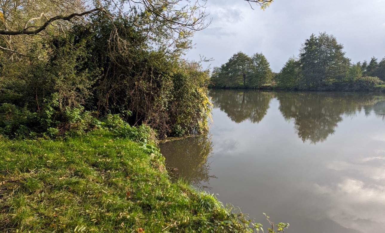
×![]()
The River Thames is generally hidden by mature riparian vegetation:
Grazing sheep on the floodplain at Mapledurham:

×![]()
Grazing sheep on the floodplain at Mapledurham:
Description
Natural (landform, water, semi-natural land cover)
- Chalk formations, including Zig Zag, West Melbury Marly, Seaford and Newhaven Formations Overlain by alluvium deposits along the course of the River Thames and gravel deposits further away from the river channel.
- The River Thames is central to this landscape, running along the western and southern boundaries of the LCA. The force of the river is most obvious at the dramatic Goring gap, where the river has carved a distinct valley through the chalk uplands, dividing the Chiltern Hills (east) from the North Wessex Downs (west, continuing into West Berkshire). The steep wooded Chiltern hills rise to the east above the valley sides. The line of the hills appears as an escarpment with numerous protruding spurs and narrow valleys that cut back into the adjoining plateau landscape to create a complex topography. The river channel lies around 45 metres Above Ordnance Datum (AOD), while the Chilterns valley sides rise to 135 metres AOD.
- The steep eastern valley sides are cloaked in a mosaic of woodland blocks and open grassland, some of which is Ancient Woodland. Hartslock Wood is an area of species-rich chalk downland, ancient yew wood and riverine fen designated internationally as a Special Area of Conservation (SAC) and nationally as a Site of Special Scientific Interest (SSSI). It is now managed as a Wildlife Trust nature reserve and contains the extremely rare monkey orchid.
- Semi-natural habitats along the river course include lowland meadows and floodplain grazing marsh, as well as riparian woodland including conspicuous willows along the riverside.
Cultural/social (land use, settlement, infrastructure, historic character)
- The poor, heavier alluvial soils on the flat floodplain generally feature extensive cattle grazed pastures, and are still part of the functional floodplain. The gravel drifts on the steeper slopes are better drained and support intensive arable cultivation.
- Fields are bounded by species-rich hedgerows, which contribute to the strong landscape structure of hedges, trees and woods.
- This section of the Thames valley includes a string of riverside towns and settlements, including Moulsford, Goring-on-Thames, Whitchurch (linked to Pangbourne in West Berkshire) and Caversham (which now forms the northern outskirts of Reading). There is a strong local vernacular of brick and flint, with timber frame and thatched roofs in older buildings.
- Settlement pattern on the terrace gravels link to prehistoric, Roman and Saxon settlements. Their strategic position at important river crossings, and as trading or staging posts along the river and main east-west routes, was the key to their later development. The Goring, Gatehampton, Whitchurch and Mapledurham Conservation Areas extend into the river valley landscape.
- The riverside landscape, set below the picturesque, wooded Chiltern Hills was a key factor in the development of 16th to 19th century villas and parks, including at Gatehampton, Hardwick House and Mapledurham. The latter two are fine Grade I Listed Tudor brick manor houses.
- Local roads provide connections to the riverside settlements, and the Great Western main line railway cuts through the northern part of valley, passing through Goring. There are no major roads in the valley on the South Oxfordshire side of the Thames, with the A329 through Moulsford, to the west of the river, being the only ‘A’.
- The Thames Path National Trail provides access along the river from Goring to Whitchurch-on-Thames, and a small part of the Ridgeway long distance path crosses the north of the area. The Chilterns Way crosses the landscape a number of times.
- The River Thames also hosts recreational activities including rowing, boating and fishing.
Perceptual (views, tranquillity, associations)
- The steep wooded valley sides of the Chilterns form a key visual backdrop to the area. The woodlands create an intimate and enclosed character, but with some long views out across the Thames valley. In the north, there are views across the Thames valley with the Chilterns and North Wessex Downs National Landscapes on the horizon to the east and west. The River Thames is often hidden from view by riparian vegetation.
- A rural character with few detracting influences, beyond the railway line and road network (including the A329 to the south), and electricity pylons in the north-west. Proximity to the sprawling urban area of Reading in the east reduces relative tranquillity and remoteness. The Tranquillity Assessment for South Oxfordshire and Vale of White Horse categorises 88% of the LCA in Zone 2 (‘areas of some tranquillity’).
- The majority of the area is within the Chilterns National Landscape, with a small area in the north-west in the North Wessex Downs National Landscape. The only area of undesignated land is in the east.
- The River Thames in South Oxfordshire forms the setting for ‘The Wind in the Willows’, a children’s novel by Kenneth Grahame (1908).
Valued qualities
- Most of the river valley falls within the Chilterns National Landscape, and the north-western fringe is part of the North Wessex Downs National Landscape. It displays many of the special qualities including chalk landform, Yew woodlands and chalk grasslands, arable habitats with strong hedgerow network, historic attractive villages, extensive public rights of way and medieval and post-medieval settlements with historic buildings, extensive public rights of way and panoramic views towards the chalk escarpment.
- Distinctive large meanders of the River Thames, which cut through the chalk geology at the dramatic Goring gap, create a sense of place.
- Steep wooded slopes of the Chilterns contain extensive woodland habitats, including those at Hartslock Wood SAC and SSSI, which provide ecological value and form a distinctive backdrop to views both within the area and beyond.
- Historic riverside settlements and small country estates provide time-depth; the landscape provides an important riverside setting to these.
- A rural, peaceful landscape away from urban edges and main transport routes, with areas of enclosure within the woodlands and a strong sense of place.
- Recreational value along promoted routes, allowing access into the landscape, and along the Thames itself.
- Views towards the steep wooded valleys sides and views down into the valley from ridge crests within both the Chilterns and the North Wessex Downs.
Forces for change
- Historic conversion of meadow and pasture fields to arable farming, altering the characteristic river valley character of the landscape.
- Increase in horse grazing and associated facilities, changing the agricultural character.
- Poor maintenance and loss of field boundaries, resulting in gaps in hedgerows. Loss of hedgerows would increase the sense of openness and may affect the more semi-enclosed character along to the river.
- Pressure for increased development on the edges of settlements, including at Moulsford and Goring, which would affect the rural character of the landscape and setting of these settlements. Increased development pressure in neighbouring towns including Purley on Thames and Reading may also impact views from the river valley.
- The River Valley landscapes may be susceptible to the impacts of climate change, including:
- Deciduous woodlands are facing decline due to warmer winters, altered rainfall patterns, drier summers and increased frequency of extreme events; there may be a shift in vegetation type and composition, increased competition from invasive species, greater numbers of insect and mammal pests, a greater risk of infection by various soil and water-borne pathogens, and a greater risk of wind-throw and loss of mature trees.
- Mature beech trees are sensitive to drought and seasonally fluctuating water tables on less suitable soil types, which can lead to reduced growth, die-back and death; warmer winters and reduced winter cold periods can cause reduced bud initiation and a possible reduction of beech; and increased frequency of extreme weather events could cause an increased loss of beech trees to wind blow.
- Drier summers and wetter winters may lead to increased mortality and die-back of certain hedgerow tree species; an increased occurrence of insect pests and pathogens could lead to a potential loss or significant reduction in populations of key hedgerow tree species; and increased storm activity may lead to the loss of mature and veteran trees within hedgerows.
- Wetter winters may mean woody species in hedgerows are exposed to prolonged flooding in the growing season and will be at risk of dying, and winter trimming will become more difficult due to wet ground (preferred to autumn trimming to ensure food supply for birds).
- Intensification of adjacent land use leading to increased impacts on hedgerows such as pesticide drift and nutrient enrichment.
- Hotter drier summers and wetter winters and winter flooding could result in changes to wetland and riparian plant community composition; some non-native species may become invasive, and other currently geographically restricted species may spread more easily.
- Wetter winters and higher peak river flows may lead to increased flood defence activity, creating more physical habitat degradation and introducing potentially detracting features.
- Higher average temperatures and drier summers could lead to changes to community composition in arable field margins; an increase in bare ground and an increased risk of dieback in drought prone locations; the introduction of new crops and associated changes to management could alter the area and type of field margins; and an increase in agricultural use of summer insecticides which could reduce insect numbers and pollination.
- Hotter, drier summers and wetter winters will lead to changes in food production and growing seasons. Flooded land is only capable of supporting lower-value crops, pasture or woodland, which would impact important arable crops. Landscape appearance will likely also be altered, particularly if relocation of growing areas is required or crop diversification occurs (causing a need for changes in field pattern and the potential removal of field margins, hedgerows, woodlands).
- Changing temperatures and extreme weather events are creating vulnerabilities in chalk grassland landscapes, leading to increased soil erosion and run-off.
- Drier summers and wetter winters could cause changes in plant and animal species and community composition of chalk grassland (for example loss of perennials, expansion of drought-tolerant ephemerals and dominance of grasses in the sward of chalk grassland).
- Drier summers leading to an increased fire risk affecting chalk grassland habitats.
Landscape strategy and guidelines
Conserve and enhance the distinctive pattern of landscape elements which are valued as special qualities of the Chiltern and North Wessex Downs National Landscapes.
- Retain and enhance characteristic woodland cover and explore opportunities to expand and connect this through natural regeneration or small-scale planting to strengthen landscape character and bring benefits for biodiversity; conserve and manage the Ancient Woodland sites.
- Encourage the appropriate management of woodland, including to reduce the impacts of pests and diseases and to increase its age structure and structural heterogeneity. Consider the promotion of natural colonisation adjacent to existing woodland, allowing locally native species to develop resilience to the pressures of climate change through natural processes.
- Seek to prevent further loss or decline in the quality of boundary hedgerows and encourage the restoration/reinstatement of historic hedge boundaries, whilst maintaining characteristic long distance views north and south; when establishing new hedges, aim to diversify the range of species and select species and provenances adapted to a wider range of climatic conditions.
- Manage chalk grassland to enhance its biodiversity value and appearance; ensure best practice management through suitable grazing regimes and avoiding agrochemical and fertiliser inputs; manage recreational routes to avoid/minimise disturbance; and manage scrub vegetation appropriately to maintain the open character (a certain amount of scrub can be beneficial, especially on sites that are prone to heat stress or drought, due to its shading effect potentially providing refuge for invertebrates).
- Consider opportunities to increase the area of chalk grassland through re-creation and restoration around existing areas, and ensure that areas that might act as refugia from climate change (such as areas with north facing slopes, complex micro-topography and/or low nitrogen levels) are under optimal management.
- Maintain the valued recreational use of the landscape which allow appreciation of views and landscape character.
Retain and enhance the pastoral character along the river by strengthening the smaller-scale field pattern and conserving and enhancing areas of wetland and riparian habitats and the ecological value they provide. Consider opportunities to enhance the ecological value and appearance of intensively farmed arable land.
- Conserve and enhance the pattern of lowland meadows, floodplain grazing marsh and riparian vegetation along the river, to enhance their contribution to landscape character and their nature conservation value; encourage greater diversity though sympathetic management such as grazing where appropriate.
- Encourage adjacent land uses which strengthen role as ecological corridors and enhance landscape character.
- Seek opportunities to enhance connectivity with other habitats nearby by creating green corridors and networks, including to the chalk grassland and woodland found on the valley slopes.
- Consider opportunities for sympathetic, small-scale, riparian native woodland creation along watercourses to provide shade, thus helping to mitigate the warming effects of climate change on chalk stream ecology.
- Manage arable land to enhance its biodiversity value and connectivity, by maintaining and expanding the area of land available for uncultivated arable field margins; seek to maximise the diversity of margins to provide a range of habitats and to assist in the movement of species through the landscape and include species and cultivars that are able to tolerate and flower under hotter, drier summers.
Maintain the open character and recreational value of the landscape, which provides access and a rural setting to surrounding riverside settlements and small country estates.
- Retain the existing settlement patterns of riverside towns and villages, avoiding development creeping up the valley sides or ribbon development diminishing settlement separation. Any new development should use materials which are in keeping with, or complement, the local vernacular of brick, flint, timber-framing and thatched roofs.
- Use trees and woodland to integrate any new development into the landscape.
- Respect the setting of historic sites and the sensitivity of historic settlement edges, particularly the Conservation Areas of Goring, Gatehampton, Whitchurch and Mapledurham. Resist changes to the landscape which are not in keeping with the landscape character, including unsympathetic housing development.
- Protect and manage the valued recreational use of the landscape on public rights of way. Consider opportunities to improve public right of way connections, infrastructure and signage.
- Carefully consider any new applications for boathouses or jetties along the Thames, to retain the naturalistic character of the river, while ensuring it retains its recreational value.
Protect characteristic views within and outwards from the river valley.
- Protect and where possible enhance long views towards the steep wooded backdrop formed by the Chilterns Hills and North Wessex Downs. Avoid any development which would break the wooded horizon line.
- Light pollution should be avoided or reduced in this landscape, with new lighting only introduced where necessary. Consider the impact of lighting, both external and internal, on night-time views from lower ground as well as within the locality. Refer to the guidance in the Dark SkiesAssessment for South Oxfordshire and Vale of White Horse
LCA 14G: Caversham to Henley Thames River Valley
It should be noted that the lines used to denote where LCAs border settlements are approximate and should not be used for planning purposes.
LCA 14G - View the map full screen in a new tab
Character Area Summary and Location
The LCA covers the Thames River Valley from Caversham in the south-west to Henley-on-Thames in the north-east, located beneath the wooded plateau and valleys of the Chilterns (LCA 4A) within South Oxfordshire district. Land use comprises a mix of pasture and arable, with some large flooded former quarry pits east of Caversham. The river valley and slopes continue to the north and east across the administrative boundaries into Wokingham district.
Key characteristics
- The low-lying River Thames floodplain, with gently rising valley sides extending north into the Chiltern Hills. Underlying gravels have been extensively exploited, resulting in large, flooded gravel pits east of Caversham.
- Wetland habitats, including riparian woodland and floodplain grazing marsh, along the river course and small woodland blocks on the valley sides.
- Mixed agricultural landscape with pasture fields adjacent to the river, and large-scale arable fields with few field boundaries.
- Development within the LCA is concentrated at the small villages of Playhatch and Sonning Eye but several large riverside towns lie on the outer edges of this landscape, including Caversham, Lower Shiplake and Henley-on-Thames.
- Sonning Eye is typical of the floodplain edge village and is noted for the use of local vernacular flint, warm traditional red brick and tile, with dark weatherboarding; the village is covered by a Conservation Area.
- Recreational opportunities provided by the Thames Path National Trail, the Chiltern Way, a local network of public rights of way, the flooded gravel pits and the River Thames itself (including boating, rowing and fishing). However, much of the area has no public access.
- An open character with views available along the river corridor, sometimes framed by bankside vegetation. Rising slopes of the Chiltern Hills form a wooded backdrop to the north and create a more enclosed character with limited long-distance views.
- A generally rural landscape, although impacted by proximity to large urban areas, active quarrying and the busy A4155 and Great Western main line.
Canal boats moored at Caversham Lakes:

×![]()
Canal boats moored at Caversham Lakes:
Urban edge of Reading visible over rolling fields at Playhatch:

×![]()
Urban edge of Reading visible over rolling fields at Playhatch:
Meandering river Thames with mature riparian vegetation at Sonning:

×![]()
Meandering river Thames with mature riparian vegetation at Sonning:
Grade II* church of St Peter and St Paul, Shiplake:

×![]()
Grade II* church of St Peter and St Paul, Shiplake:
Description
Natural (landform, water, semi-natural land cover)
- Chalk formations, including Lewes Nodular, Seaford, Newhaven, Holywell Nodular and New Pit Formations overlain by alluvium deposits along the river and extensive river terrace gravel deposits further away from the river channel. These have been quarried to the east of Caversham to create a series of flooded gravel pits.
- The flat floodplain lies a little over 30 metres Above Ordnance Datum (AOD) . The valley sides are gentle, and grade into the Chilterns dip slopes to the north, rising to 80 metres AOD.
- The River Thames has a strong influence on the character of this area, much of which is prone to flooding.
- Diverse, scattered wetland and woodland habitats, including considerable priority habitat floodplain grazing marsh east of Sonning, and riparian woodland including conspicuous willows along the riverside. The flooded gravel pits east of Caversham are being recolonised by semi-natural vegetation, which increases their wildlife value.
- Small areas of priority habitat deciduous woodland are scattered across the area. Spanhill Copse is the only Ancient Woodland, although it has been replanted rather than in continual existence.
Cultural/social (land use, settlement, infrastructure, historic character)
- Pasture fields with poor soils immediately adjacent to the river channel have a simple, rural character. Farmland on the rising valley sides consists of large-scale arable fields which are often open, or divided by drainage ditches or post and wire fences. Some areas of pasture have been subdivided for horse paddocks bounded by fences and drainage ditches.
- Ongoing mineral extraction east of Sonning Eye changes the landscape of this area, although is screened by vegetation and has no public access.
- The Thames-side terrace gravels have been a favoured area for settlement since prehistoric times. This section of the Thames valley includes a string of riverside towns and settlements, including Caversham (which now forms the northern outskirts of Reading), Lower Shiplake and Henley-on-Thames. Many of these can trace origins back to prehistoric, Roman and Saxon times, and their strategic position at important river crossings, and as trading or staging posts along the river and main east-west routes, was the key to their later development. Historic buildings relating to the river including the landmark Grade I Listed stone bridge at Henley-on-Thames and varied styles of boat houses area add to the historic character, and are also aesthetically pleasing.
- Sonning Eye is typical of the floodplain edge settlements further east on the Thames valley, and is noted for the combination of local building materials including flint, warm traditional red brick and tile, with dark weatherboarding. Brick banding and timber-framing with pitched and half-hipped roofs are also features. The village is covered by a Conservation Area.
- Part of the Grade II* Fawley Court Registered Park and Garden (RPG), an example of a number of villas and parks located between the wooded Chiltern Hills and the river, extends into South Oxfordshire but is predominantly in Buckinghamshire., . This area is covered by the Henley Conservation Area, and is also within the Chilterns National Landscape. The land at Shiplake House (Grade II Listed 19th century house) also has a parkland character.
- The A4155 is a busy road which runs at the base of the valley slopes. New ribbon development along the A4155 is creating a more residential character along the road.
- Minor local roads provide access to the small villages in and close to the floodplain, although there are considerable areas with no vehicular access. The Great Western main line railway runs between Henley-on-Thames and Lower Shiplake in the east.
- The Thames Path National Trail passes through the valley from east of Sonning Bridge, while the Chiltern Way joins the riverside walk from Lower Shiplake. A network of public rights of way crosses the landscape, although there are considerable areas without any public access.
- The River Thames itself also provides recreational activities including boating, rowing and fishing. The flooded gravel pits east of Caversham are used for recreation including marinas and water-based recreation such as water skiing and an obstacle course.
Perceptual (views, tranquillity, associations)
- The river corridor itself has an open character, although in places views are focussed along the river channel and framed by bankside vegetation. Bankside vegetation and small areas of woodland within the floodplain create a more enclosed character, with limited long-distance views.
- Henley-on-Thames forms a backdrop to the floodplains to the north of the site particularly at Marsh meadows.
- The landscape is intact, with areas of wetland and pasture immediately adjacent to the river channel forming a functional floodplain.
- Despite its proximity to urban areas, much of the area has an intimate, pastoral and relatively tranquil character, due to its comparative inaccessibility. The Tranquillity Assessment for South Oxfordshire and Vale of White Horse categorises 68% of the LCA in Zone 2 (‘areas of some tranquillity’).
- The active gravel workings, recreational uses and proximity to roads, railway, built development and large urban centres, particularly at Reading and Caversham, intrude on the rural qualities of the area. The busy A4155 and railway line are visual and aural detractors in the landscape, while electricity pylons in the west are visual detractors. The Tranquillity Assessment for South Oxfordshire and Vale of White Horse categorises 29% of the LCA in Zone 4 (‘areas of low tranquillity’).
- Proximity to larger settlements at Reading/Caversham and Henley and lighting along the A4155 introduces light pollution. Less than 50% of this landscape is categorised as within the darkest two bands in the Dark Skies Assessment for South Oxfordshire and Vale of White Horse.
- The River Thames in South Oxfordshire forms the setting for ‘The Wind in the Willows’, a children’s novel by Kenneth Grahame (1908). Henley’s River and Rowing Museum has a permanent Wind in the Willows exhibition.
Valued qualities
- The distinctive River Thames, with its meanders and gently rising valley sides to the north and west, creates a clear sense of place.
- Wetland and riparian habitats, provide ecological value and contribute positively to the landscape.
- Pasture and arable fields provide a rural and agricultural character.
- The pattern of historic riverside settlements, including Sonning Eye, and areas of parkland provide historic character and time-depth, with the landscape providing an open rural setting to these. Fawley Court is a garden and pleasure grounds designed in the 1770s by Lancelot Brown.
- The Thames Path National Trail, Chilterns Way and water-based recreation on the Thames at the flooded gravel pits provide recreational access and value.
- The open river corridor contrasts with the more enclosed character of the floodplain, creating visual interest.
- A rural landscape with a good sense of tranquillity and some areas of relative remoteness.
- Characteristic views focussed along the river channel, framed by bankside vegetation.
- Views towards the steep wooded valley side and views down into the valley from higher ground within the Chilterns and from the east/south of the Thames.
- The value of the landscape is demonstrated by its inclusion within the Henley to Sonning Eye Thames Floodplain Local Landscape Designation.
Forces for change
- Historic conversion of meadow and pasture fields to arable farming, altering the characteristic river valley character of the landscape.
- The presence of Himalayan balsam along the River Thames which is an invasive species and can be a threat to native plants that are more ecologically beneficial to insects.
- Poor maintenance and loss of field boundaries, resulting in gaps in hedgerows. Loss of hedgerows would increase the sense of openness and may affect the more semi-enclosed character along to the river.
- Increase in horse grazing and associated facilities, changing the agricultural character.
- Pressure for increased development on the edges of Henley-on-Thames, Lower Shiplake and Caversham, and potentially also development at or near Reading, to the south of the Thames, which would affect the rural character of the landscape and setting of these settlements. Further development along the A4155 could also risk the perception of coalescence between Lower Shiplake and Shiplake.
- Potential pressure for further recreational jetties, structures and large boat houses along the River Thames, which could introduce a more developed character.
- The River Valley landscapes may be susceptible to the impacts of climate change, including:
- Deciduous woodlands are facing decline due to warmer winters, altered rainfall patterns, drier summers and increased frequency of extreme events; there may be a shift in vegetation type and composition, increased competition from invasive species, greater numbers of insect and mammal pests, a greater risk of infection by various soil and water-borne pathogens, and a greater risk of wind-throw and loss of mature trees.
- Drier summers and wetter winters may lead to increased mortality and die-back of certain hedgerow tree species; an increased occurrence of insect pests and pathogens could lead to a potential loss or significant reduction in populations of key hedgerow tree species; and increased storm activity may lead to the loss of mature and veteran trees within hedgerows.
- Wetter winters may mean woody species in hedgerows are exposed to prolonged flooding in the growing season and will be at risk of dying, and winter trimming will become more difficult due to wet ground (preferred to autumn trimming to ensure food supply for birds).
- Intensification of adjacent land use leading to increased impacts on hedgerows such as pesticide drift and nutrient enrichment.
- Hotter drier summers and wetter winters and winter flooding could result in changes to wetland and riparian plant community composition; some non-native species may become invasive, and other currently geographically restricted species may spread more easily.
- Wetter winters and higher peak river flows may lead to increased flood defence activity, creating more physical habitat degradation and introducing potentially detracting features.
- Higher average temperatures and drier summers could lead to changes to community composition in arable field margins; an increase in bare ground and an increased risk of dieback in drought prone locations; the introduction of new crops and associated changes to management could alter the area and type of field margins; and an increase in agricultural use of summer insecticides which could reduce insect numbers and pollination.
- Hotter, drier summers and wetter winters will lead to changes in food production and growing seasons. Flooded land is only capable of supporting lower-value crops, pasture or woodland, which would impact important arable crops. Landscape appearance will likely also be altered, particularly if relocation of growing areas is required or crop diversification occurs (causing a need for changes in field pattern and the potential removal of field margins, hedgerows, woodlands).
Landscape strategy and guidelines
Woodland cover should continue to contribute to rural character and sense of tranquillity along watercourses by providing enclosure and helping to limit the urbanising visual influence of surrounding settlements and roads. Look to increase this to provide additional landscape structure and ecological value, whilst maintaining characteristic views along the river.
- Retain and enhance woodland cover and hedgerows along the river and floodplain, and scattered blocks of woodland on the valley sides.
- Explore opportunities to expand and connect existing woodland and tree cover through natural regeneration or small-scale planting. This will strengthen landscape character and bring benefits for biodiversity.
- Protect and where possible enhance characteristic views along the river by framing views with bankside vegetation.
- Encourage the appropriate management of woodland, including to reduce the impacts of pests and diseases and to increase its age structure and structural heterogeneity. Consider the promotion of natural colonisation adjacent to existing woodland, allowing locally native species to develop resilience to the pressures of climate change through natural processes.
- Seek to prevent further loss or decline in the quality of boundary hedgerows and encourage their restoration/reinstatement; when establishing new hedges, aim to diversify the range of species and select species and provenances adapted to a wider range of climatic conditions.
- Use trees and woodland to integrate any new development into the landscape.
Retain and enhance the pastoral character along the river by strengthening the smaller-scale field pattern and conserving and enhancing areas of wetland and riparian habitats and the ecological value they provide. Consider opportunities to enhance the ecological value and appearance of intensively farmed arable land.
- Conserve and enhance the pattern of floodplain grazing marsh and riparian vegetation along the river, to enhance their contribution to landscape character and their nature conservation value.
- Encourage adjacent land uses which strengthen role as ecological corridors and enhance landscape character.
- Seek opportunities to enhance connectivity with other habitats nearby by creating green corridors and networks, including the woodland of the adjacent valley slopes and the Chilterns National Landscape.
- Manage arable land to enhance its biodiversity value and connectivity, by maintaining and expanding the area of land available for uncultivated arable field margins; seek to maximise the diversity of margins to provide a range of habitats and to assist in the movement of species through the landscape and include species and cultivars that are able to tolerate and flower under hotter, drier summers.
Maintain the open character and recreational value of the landscape, which provides access and a rural setting to surrounding settlements, including the historic village of Sonning Eye.
- Minimise the impact of any new development on local character and on views from adjacent higher ground. Use materials which are in keeping with, or complement, the local vernacular of red brick, tile, flint, brick banding and timber-framing.
- Maintain the riverside settlement pattern. Ensure any further ribbon development along the A4155 does not result in perceived coalescence between settlements.
- Protect and manage the valued recreational use of the landscape on public rights of way. Consider opportunities to improve public right of way connections, infrastructure and signage.
- Carefully consider any new applications for boathouses, jetties or other structures along the Thames, to balance retaining the naturalistic character of the river with ensuring it retains its recreational value.
- Respect the setting to the Conservation Areas and the sensitivity of historic settlement edges, by resisting changes to the landscape which are not in keeping with the landscape character, including unsympathetic housing developments.
Historic parklands, and the historic value and landscape diversity they provide, should be conserved and enhanced.
- Conserve and manage historic parkland at Fawley Court, including its garden and pleasure grounds. Replant key ornamental tree species to retain the parkland character where necessary.