LCT 10: Lower Vale Hills
Landscape character type summary
The Lower Vale Hills are chalk outliers surrounded by lower-lying clay vales. This makes them a very distinctive landscape element, with the tree-capped Sinodun Hills (Wittenham Clumps) prominent in views from the vales and the higher ground of the North Wessex Downs, the Chilterns and the Midvale Ridge. They in turn offer panoramic views of the Districts’ landscapes, including the River Thames meandering across the lower vale.
One landscape character area (LCA) is identified:
- LCA 10A: Sinodun Lower Vale Hills.
LCA 10A: Sinodun Lower Vale Hills
It should be noted that the lines used to denote where LCAs border settlements are approximate and should not be used for planning purposes.
LCA 10A - View the map full screen in a new tab
Character Area Location
Didcot. It comprises an isolated chalk ridge that rises above the lower-lying East Thames Lower Vale (LCA13C) to the north and the Southern Thames Vale (LCA 13D) to the south. The LCA is located almost entirely within the North Wessex Downs National Landscape.
Key characteristics
- An isolated chalk ridge, forming an outlier of the North Wessex Downs; distinctive prominent rounded hills include Round Hill and Castle Hill (the Sinodun Hills, more commonly referred to as Wittenham Clumps), and Brightwell Barrow.
- Large-scale intensive arable farmland dominates, with some areas of open grassland, meadows and traditional orchards in places providing contrast.
- Deciduous woodland occurs in scattered blocks and belts around farms, and in larger blocks at Long Wittenham Wood and Little Wittenham Wood. Beech trees on Round Hill and Castle Hill – Wittenham Clumps – form a distinctive landmark and prominent feature on the skyline in views from surrounding lower lying areas.
- The dispersed settlement pattern of stone-built scattered farmsteads on the lower slopes contributes to the rural, agricultural character.
- A predominantly open landscape with extensive views from higher ground, including south towards the Wessex Downs scarp. Remnant tall industrial features at the former Didcot Power Station are often a dominant feature in views to the west.
- Long history of settlement in the area with features dating from prehistoric (Iron Age and Bronze Age) as well as Roman periods.
- A rural and peaceful landscape with limited modern development. Nearby main roads introduce some visual and audible detractors to the south.
Panoramic views to the north from Round Hill:
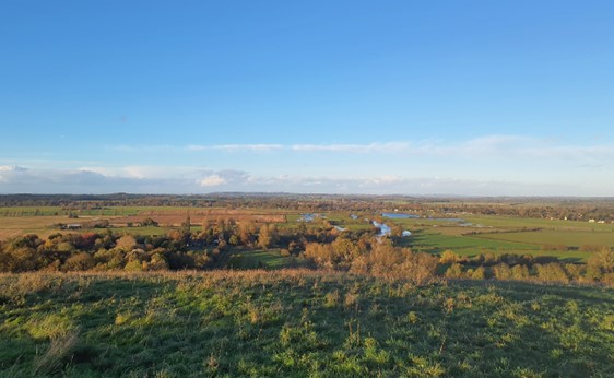
×![]()
Panoramic views to the north from Round Hill:
Large-scale arable agriculture in the east:

×![]()
Large-scale arable agriculture in the east:
Wittenham Clumps are prominent in the Lower Vale landscape:

×![]()
Wittenham Clumps are prominent in the Lower Vale landscape:
Castle Hill:

×![]()
Castle Hill:
Description
Natural (landform, water, semi-natural land cover)
- An isolated chalk ridge at the Sinodun Hills, an outlier of the Wessex Downs chalk escarpment. Rising from the surrounding vale – which is around 60 metres Above Ordnance Datum (AOD) – isolated outcrops of greensand and chalk form prominent rounded hills including Round Hill (121 metres AOD), Castle Hill (121 metres AOD), and Brightwell Barrow (113 metres AOD).
- Parts of the area are overlain by clay with flints, producing distinctively ‘grey’ and flinty soils; flint is conspicuous in the soils and buildings, forming part of the architectural vernacular.
- The two clumps of beech trees on Round Hill and Castle Hill – Wittenham Clumps – are distinctive Ancient Woodland features. Deciduous woodland occurs in scattered blocks and belts around farms, and in larger blocks at Little Wittenham Wood and Long Wittenham Wood. The former is prominent on the northern face of Castle Hill, running down to the River Thames, designated as Ancient Woodland but also, with grassland on Castle Hill and on lower ground around Little Wittenham, a Special Area of Conservation (SAC) and Site of Special Scientific Interest (SSSI).
- Outside of Wittenham Clumps, areas of priority habitat traditional orchards are found near settlements. There are also small, fragmented areas of priority habitat lowland calcareous grassland, semi-improved grassland and lowland meadows.
Cultural/social (land use, settlement, infrastructure, historic character)
- Predominantly agricultural land use, comprising large-scale arable fields bounded by species-rich hedgerows. There are some small areas of pasture on the northern edges of the area and on the hillsides of Whittenham Clumps.
- Sparsely settled; the linear village of Little Wittenham extends into the north of the area (including its Conservation Area), while scattered farmsteads are typically located along the lower slopes of the hills.
- Greens, fairways and buildings associated with Hadden Hill Golf club have a localised detracting influence on landscape character towards the edge of Didcot.
- The A4130 main road crosses through the south of area and introduces some visual and aural disruption. Elsewhere, minor rural roads connect the scattered farms with nearby settlements (in adjacent LCAs).
- Evidence of a long history of settlement is indicated by the presence of Bronze Age Brightwell Barrow and Iron Age Sinodun Hill fort (both Scheduled Monuments).
- Wittenham Clumps are a popular spot with walkers, and public rights of way provide access across this landscape.
Perceptual (views, tranquillity, associations)
- Wittenham Clumps are a key landscape feature in this area and in views from surrounding lower lying landscapes, forming a prominent and distinctive feature on the skyline.
- The open landscape results in extensive views from the hilltops and downs across the vale to the north, east and west. Hedgerows, trees and woodlands provide some visual enclosure and restrict intervisibility in some places.
- The majority of the LCA falls within the North Wessex Downs National Landscape (excluding Down Hill and Hadden Hill Golf Club), valued for its scenic and perceptual qualities.
- There are views to remnant tall industrial features at the former Didcot Power Station and recent and ongoing development on the eastern edge of Didcot (as part of the Didcot North East Strategic Allocation), which reduce the sense of remoteness. The A4130 on the southern boundary is locally audibly disturbing, but the area’s elevation also provides strong views over open countryside, and generally there is a sense of rurality and distance from urban influences. The Tranquillity Assessment for South Oxfordshire and Vale of White Horse categorises 96% of the LCA in Zone 2 (‘areas of some tranquillity’).
- Away from the fringes of Didcot, Brightwell and Shillingford there are also dark night skies. Over 90% of this landscape is categorised as within the darkest band in the Dark Skies Assessment for South Oxfordshire and Vale of White Horse.
- The Wittenham Clumps have inspired poets and artists, including the landscape artist Paul Nash who painted the Clumps many times during his career.
Valued qualities
- Located almost entirely within the North Wessex Downs National Landscape, and displays several of the special qualities including Ancient Woodland, chalk grasslands, arable habitats, prehistoric monuments, sparse settlement pattern and extensive public rights of way.
- Wittenham Clumps form a distinctive landmark in views from the surrounding lower-lying vales. The hills are also nationally and internationally valued for their Ancient Woodland and grasslands, reflected in SAC and SSSI designations.
- Long-ranging, panoramic views, especially from the elevated land, provide a distinctive sense of place and tranquillity. Round Hill is identified as a ‘viewpoint’ on Ordnance Survey maps.
- Recreational value of the network of public rights of way, including access to the Sinodun Hills and Brightwell Barrow.
- Historic assets including prehistoric earthworks and an Iron Age hillfort create time-depth.
- Areas of open grassland, meadows and orchards contrast with the intensively managed arable land, providing texture and visual interest to the landscape. Remnant areas of orchards to the north of Brightwell-cum-Sotwell also provide links to historic land uses and contribute to historic landscape character.
Forces for change
- Loss of hedges and fragmentation of the hedgerow network along field boundaries and a decline in the management of existing woodlands and trees. This increases the sense of openness and affects the pattern of scattered blocks and belts of deciduous woodland.
- Pressure for increased development on the eastern edge of Didcot, which may extend into this landscape. This would have a localised effect on the rural character and would also impact valued panoramic views outward.
- Increased recreation at Wittenham Clumps, which may result in pressure for further recreational facilities including car parks, altering the rural character. Wittenham Clumps and Little Wittenham Wood are managed by the Earth Trust, which has been replenishing the end-of-life beech trees on the Clumps with hornbeam and lime.
- An increase in traffic leading to noise and light pollution from the A4130 which would undermine the rural character and sense of tranquillity.
- Demolition of Didcot Power Station has altered views west, including from Wittenham Clumps. Redevelopment of this site may also impact views from higher ground.
- The Lower Vale Hills landscape may be susceptible to the impacts of climate change, including:
- Deciduous woodlands are facing decline due to warmer winters, altered rainfall patterns, drier summers and increased frequency of extreme events; there may be a shift in vegetation type and composition, increased competition from invasive species, greater numbers of insect and mammal pests, a greater risk of infection by various soil and water-borne pathogens, and a greater risk of wind-throw and loss of mature trees.
- Drier summers and wetter winters may lead to increased mortality and die-back of certain hedgerow tree species; an increased occurrence of insect pests and pathogens could lead to a potential loss or significant reduction in populations of key hedgerow tree species; and increased storm activity may lead to the loss of mature and veteran trees within hedgerows.
- Intensification of adjacent land use leading to increased impacts on hedgerows such as pesticide drift and nutrient enrichment.
- Changing temperatures, drier summers and wetter winters and extreme weather events are creating vulnerabilities in grassland landscapes, including increased soil erosion and run-off; changes in plant and animal species and community composition; and an increased fire risk.
Landscape strategy and guidelines
Maintain and enhance the distinctive pattern of scattered woodland on hilltops and slopes which form notable features in the otherwise open arable landscape.
- Retain and enhance scattered woodland and explore opportunities to expand and connect existing woodland and tree cover through natural regeneration or small-scale planting to strengthen landscape character and bring benefits for biodiversity; conserve and manage the Ancient Woodland sites.
- Encourage the appropriate management of woodland, including to reduce the impacts of pests and diseases and to increase its age structure and structural heterogeneity. Consider the promotion of natural colonisation adjacent to existing woodland, allowing locally native species to develop resilience to the pressures of climate change through natural processes.
- Seek to prevent further loss or decline in the quality of remaining boundary hedgerows and encourage their restoration/reinstatement, whilst maintaining characteristic long-distance views outward from the LCA; when establishing new hedges, aim to diversify the range of species and select species and provenances adapted to a wider range of climatic conditions.
Maintain and enhance areas of grassland, meadows and remnant orchards and the ecological value, historic character, texture and visual interest they provide. Consider opportunities to enhance the ecological value and appearance of intensively farmed arable land.
- Manage grassland habitats to enhance their biodiversity value and appearance; ensure best practice management through suitable grazing regimes and avoiding agrochemical and fertiliser inputs; manage recreational routes to avoid/minimise disturbance; and manage scrub vegetation appropriately to maintain the open character (a certain amount of scrub can be beneficial, especially on sites that are prone to heat stress or drought, due to its shading effect potentially providing refuge for invertebrates).
- Consider opportunities to increase the area of characteristic grassland habitats through re-creation and restoration around existing areas, and ensure that areas that might act as refugia from climate change (such as areas with north facing slopes, complex micro-topography and/or low nitrogen levels) are under optimal management.
- Encourage the traditional farming practice and maintain and restore orchards and other horticultural uses where appropriate, including the remaining older orchard trees which have visual and biodiversity value and sense of time depth.
- Manage arable land to enhance its biodiversity value and connectivity, by maintaining and expanding the area of land available for uncultivated arable field margins; seek to maximise the diversity of margins to provide a range of habitats and to assist in the movement of species through the landscape and include species and cultivars that are able to tolerate and flower under hotter, drier summers.
Maintain the open rural character of the landscape which provides a setting to important heritage assets and creates a sense of tranquillity. Protect panoramic views outwards and consider the role of Wittenham Clumps as a distinctive landmark on the skyline in views from surrounding lower lying areas.
- There is limited scope for development that would not detract from the valued qualities of the Lower Vale Hills. Any new development should retain the small-scale, scattered settlement pattern.
- Preserve the open views to and from Wittenham Clumps.
- Avoid the adverse impact of any new development on local character and on views from other areas. Use careful design, in terms of siting, scale, style, layout and materials to stay in keeping with existing scattered, small-scale settlement character. Preserve the openness of areas/features which are important to the landscape setting of settlements.
- Light pollution should be avoided in this landscape. Consider the impact of lighting on night-time views from surrounding areas (refer to the guidance in the Dark Skies / Light Impact Assessment for South Oxfordshire and Vale of White Horse).
- Protect and where possible enhance panoramic open views over the surrounding lower lying areas.
- Consider the impact of new development outside the LCA on the eastern edge of Didcot and redevelopment of the Didcot Power Station site, on views from the Lower Vale Hills.
- Protect heritage features that contribute to the sense of time depth in the landscape, and their open settings, including Castle Hill fort and Brightwell Barrow.
- Maintain the valued recreational use of the landscape which allow appreciation of views and landscape character. Carefully consider any new recreational facilities such as car parks and buildings, balancing the recreational need with maintaining the open, rural landscape.