LCT 13: Lower Vale
Landscape character type summary
The clay vales, which form the majority of the land area within South Oxfordshire and Vale of White Horse, are located beneath the chalk downlands and Midvale Ridge. They are divided into Upper, Middle and Lower Vales. The Lower Vales are the lowest-lying clay-based landscapes, generally below 55 metres Above Ordnance Datum (AOD), centred around the River Thames south of the Midvale Ridge, north of the North Wessex Downs and west of the Chilterns. Sand and gravel deposits are characteristic of the Lower Vale areas and landscapes resulting from the working of these deposits are characteristic of the area between Abingdon and Didcot. East and west of this the Lower Vales are largely under arable cultivation, in larger, flatter fields than are characteristic of the Middle and Upper Vales.
Four landscape character areas (LCA) are identified:
- LCA 13A: Ock Lower Vale
- LCA 13B: Abingdon-Didcot Lower Vale
- LCA 13C: East Thames Lower Vale
- LCA 13D: South Thames Lower Vale
LCA 13A: Ock Lower Vale
It should be noted that the lines used to denote where LCAs border settlements are approximate and should not be used for planning purposes.
LCA 13A - View the map full screen in a new tab
Character Area Location
Located to the south-west of Abingdon-on-Thames in Vale of White Horse District, the LCA comprises low-lying land associated with the River Ock and its floodplain. The relatively flat, shallow ‘bowl’ landform is contained by surrounding higher ground of the wooded limestone ridge to the north (LCA 8A-C), with gently rising vale landscapes continuing to the south, west and east ((LCA 12B and LCA 13B).
Key characteristics
- Distinctively flat, flow-lying landform with very little topographic variation. The River Ock flows through the area towards the River Thames, fed by a number of smaller streams and brooks.
- A predominantly arable landscape of large-scale irregular-shaped fields bounded by a network of ditches or low and gappy hedgerows; some smaller-scale pastoral fields adjacent to the River Ock.
- Woodland cover is limited to small scattered mixed deciduous woodland copses and coniferous plantations, often associated with farmsteads. These combine with mature trees and riparian vegetation along the meandering watercourses, resulting in a greater sense of woodland cover.
- Semi-natural habitats include a large area of floodplain grazing marsh associated with pastures along the River Ock.
- Sparse settlement pattern of Garford village in the north and scattered farmsteads, with limited road access. The presence of several mill buildings and the former Wilts and Berks canal reflects the industrial heritage of the area.
- A well-connected network of public rights of way crosses the landscape, linking settlements in adjacent character areas; there is more limited access to the north.
- Open to semi-enclosed views are afforded across much of the landscape, although in some areas higher hedgerows, mature trees, and woodland copses and plantations limit views. Intervisibility with the North Wessex Downs National Landscape to the south and the Corallian Limestone Ridge to the north provides wooded horizons to most views.
- There is a sense of tranquillity and remoteness in the core floodplain, by virtue of the lack of settlement and limited public access. Proximity to main roads reduces tranquillity elsewhere, and solar farms, and a large warehouse complex, are modern features in the south.
The River Ock and floodplain, close to the edge of Abingdon:
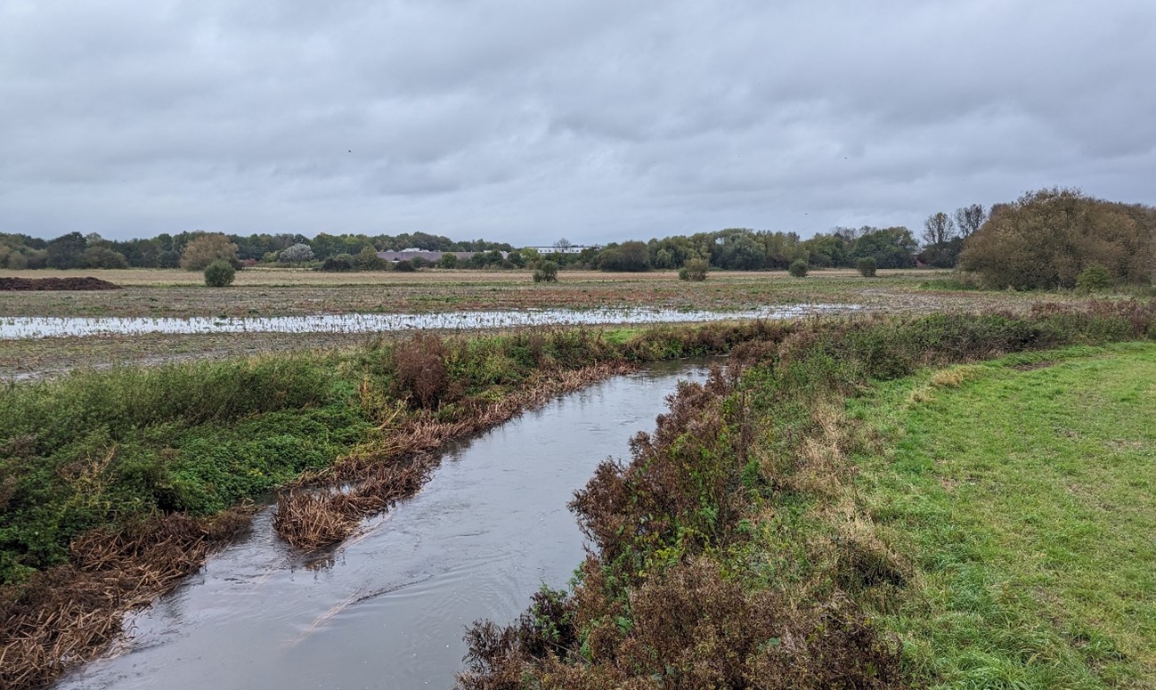
×![]()
The River Ock and floodplain, close to the edge of Abingdon:
Solar farm contained by scrubby hedgerows near Steventon:

×![]()
Solar farm contained by scrubby hedgerows near Steventon:
Garford seen across open arable fields:
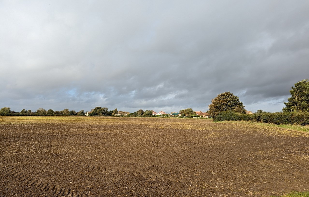
×![]()
Garford seen across open arable fields:
The A34 crosses the landscape:
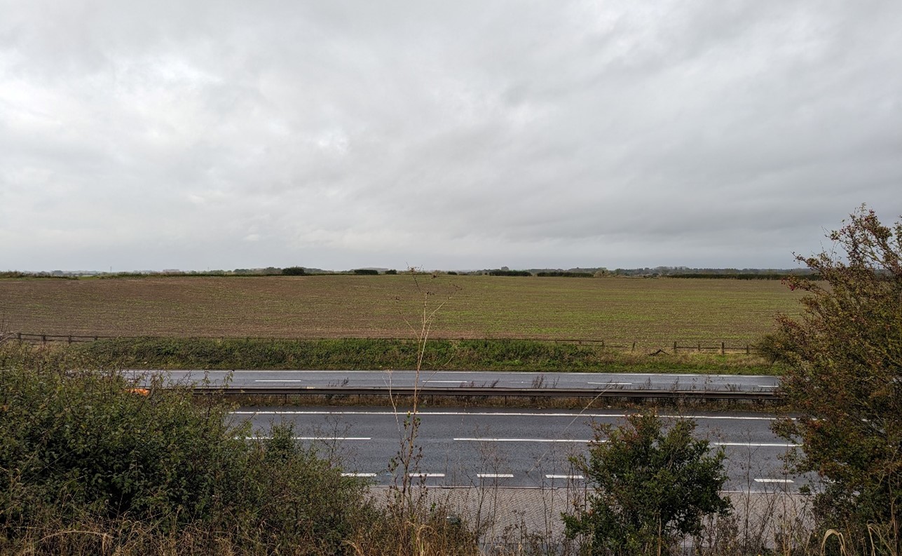
×![]()
The A34 crosses the landscape:
Description
Natural (landform, water, semi-natural land cover)
- Underlying geology comprises Ampthill Clay Formation and Kimmeridge Clay Formation, and areas of the Gault Mudstone Formation. The river corridor is underlain by Stanford Formation Limestone bedrock geology, with alluvium clay, silt, sand and gravel superficial deposits.
- Distinctively flat, low-lying landform at around 60 metres Above Ordnance Datum (AOD) with very little topographic variation.
- The River Ock runs through north and east of the landscape. A dense network of minor watercourses also drains the landscape, including Nor Brook, Childrey Brook and Mere Dike.
- Woodland cover comprises mixed deciduous woodland and coniferous plantations in small angular or linear copses, sometimes associated with farmsteads. The riparian corridor along the River Ock is densely vegetated with species including ash, willow and poplar.
- A large area of priority habitat floodplain grazing marsh is associated with the floodplain of the River Ock. Ock Meadow Nature Reserve is a locally important site.
Cultural/social (land use, settlement, infrastructure, historic character)
- Land use is primarily arable, with large-scale, irregular shaped fields.
- Field boundaries are often open, formed by drainage ditches and watercourses. Elsewhere boundary vegetation varies, with some fields without significant vegetation, or with broken tree lines. Where intact, hawthorn hedges along field boundaries and roads are generally maintained to low heights. There is some reinforcement by post and wire fencing.
- Land adjacent to the River Ock comprises smaller-scale pastoral fields of floodplain grazing.
- Settlement within the area is limited to the linear village of Garford in the north and a handful of farms, but the larger villages of Steventon and East Hanney abut the Lower Vale to the south and Marcham does likewise to the north. To the east of the A34 the Lower Vale meets Abingdon and Drayton.
- The presence of the partially restored, partially derelict Wilts and Berks Canal, and mills (such as Venn Hill and Marcham Mill, both Grade II Listed) reflect the industrial heritage of the area.
- Limited internal road access along a couple of rural lanes. In contrast busy A roads run close to the LCA edges, including the A34 in the east, the A415 in the north and the A338 in the west.
- Public rights of way provide access across the landscape, linking small farmsteads and settlements in adjacent character areas. These include a small part of the Wilts & Berks Canal, which linked the Kennet and Avon Canal with the River Thames at Abingdon.
- Two large areas of solar farms are relatively inconspicuous in the landscape due to the uniform, low-lying topography and surrounding vegetation, particularly Langmead Solar farm which is enclosed by a tree belt. Solar PV panels are visible in close proximity from some locations along Hanney Road.
Perceptual (views, tranquillity, associations)
- Open views across the flat, large-scale landscape are frequent due to the uniform topography and limited intervening vegetation. Long views south to the North Wessex Downs National Landscape and north towards the Corallian Limestone Ridge are possible, and create a wooded horizon, reinforcing the sense of being located within a broad vale landscape.
- An electrical sub-station is a prominent structure seen to the north-west of Steventon, with associated connecting electricity pylon routes visible across the area.
- The area provides a physical gap and contributes to the sense of separation between Steventon, Drayton and Abingdon, between Abingdon and Marcham, and between East and West Hanney.
- There are some views to settlement edges But woodland blocks, belts and tree lines close to settlements add texture and height to the landscape and provide some screening to development. Abingdon is largely screened from view from the west by tree cover along the A34.
- Modern developments increase in the south, including solar farms and a substation, combined with visual and audible disruption form traffic on the roads. In contrast, much of the rest of the area has a more rural character.
- There is a degree of tranquillity and remoteness across much of the Lower Vale, by virtue of the lack of settlement and limited public access, particularly where tree cover creates some containment around the smaller fields close to the River Ock. However, the busy A roads (A338, A34 and A415) are audibly present across much of the landscape, and solar farms, a large warehouse complex, and proximity to main roads (including the A34) introduce detracting features in the south. The Tranquillity Assessment for South Oxfordshire and Vale of White Horse categorises almost 90% of the LCA in Zone 2 (‘areas of some tranquillity’).
- Roads and settlements introduce light pollution around the margins of the Lower Vale but almost half of the area is classified in the darkest of the assessment bands defined in the Dark Skies Assessment for South Oxfordshire and Vale of White Horse.
Valued qualities
- The pastoral character along the River Ock and other watercourses with smaller-scale pastoral fields, riparian vegetation and floodplain grazing marsh contributing positively to the landscape.
- Recreational access to the landscape via a network of local public rights of way, including along the partially restored Wilts and Berks Canal.
- Historic mill buildings associated with the river contribute to the time-depth and historic character to the area.
- Open views across the landscape and intervisibility with the elevated North Wessex Downs National Landscape to the south, and the Corallian Limestone Ridge to the north.
- Hedgerows, riparian woodland along watercourses and scattered woodland copses result in a greater sense of woodland cover, providing some visual screening and structure to the landscape.
- Sparsely settled landscape with a rural character and sense of tranquillity and remoteness, particularly in the centre.
- Provides a physical gap and sense of separation between settlements on the edges of the Lower Vale, including between Abingdon, Drayton and Steventon, and between East and West Hanney.
Forces for change
- Loss of hedges and fragmentation of the hedgerow network along field boundaries and a decline in numbers of hedgerow trees and riparian vegetation along ditches. This increases the sense of openness and may affect the more semi-enclosed character close to the river.
- Introduction of solar farm developments, changing the traditional agricultural land uses and having a localised impact on views across the landscape.
- Agricultural intensification, diversification and amalgamation of fields into larger parcels of arable land, affecting the landscape pattern and smaller-scale pastoral character along watercourses.
- Pressure for increased development on the edges of Marcham (including as part of the South-East of Marcham Strategic Allocation) and Steventon and along the western edge of Abingdon (albeit the latter is likely to remain physically contained by the A34). This could affect the sparse settlement pattern and rural character.
- Continued restoration of the Wilts & Berks Canal, including a new section through this landscape, which will partially alter the character. This may also lead to increased recreation, loss of vegetation and a demand for greater visitor facilities, altering the rural character.
- The Lower Vale landscapes may be susceptible to the impacts of climate change, including:
- Deciduous woodlands are facing decline due to warmer winters, altered rainfall patterns, drier summers and increased frequency of extreme events; there may be a shift in vegetation type and composition, increased competition from invasive species, greater numbers of insect and mammal pests, a greater risk of infection by various soil and water-borne pathogens, and a greater risk of wind-throw and loss of mature trees.
- Drier summers and wetter winters may lead to increased mortality and die-back of certain hedgerow tree species; an increased occurrence of insect pests and pathogens could lead to a potential loss or significant reduction in populations of key hedgerow tree species; and increased storm activity may lead to the loss of mature and veteran trees within hedgerows.
- Wetter winters may mean woody species in hedgerows are exposed to prolonged flooding in the growing season and will be at risk of dying, and winter trimming will become more difficult due to wet ground (preferred to autumn trimming to ensure food supply for birds).
- Intensification of adjacent land use leading to increased impacts on hedgerows such as pesticide drift and nutrient enrichment.
- Hotter drier summers and wetter winters and winter flooding could result in changes to wetland and riparian plant community composition; some non-native species may become invasive, and other currently geographically restricted species may spread more easily.
- Wetter winters and higher peak river flows may lead to increased flood defence activity, creating more physical habitat degradation and introducing potentially detracting features.
- Hotter, drier summers and wetter winters will lead to changes in food production and growing seasons, and are likely to cause heat stress to livestock.
- Soil moisture deficits and inundation/flooding, as well as changes in temperatures (hotter, drier, longer summers, wetter winters), could lead to changes in food production and growing seasons. Flooded land is only capable of supporting lower-value crops, pasture or woodland, which would impact important arable crops. Landscape appearance will likely also be altered, particularly if relocation of growing areas is required or crop diversification occurs (causing a need for changes in field pattern and the potential removal of field margins, hedgerows, woodlands).
- Increase in storm damage could affect veteran and mature trees, and designed landscapes.
Landscape strategy and guidelines
Maintain the open rural character of the landscape, which forms gaps between settlements and affords long distance views outwards towards the North Wessex Downs National Landscape and Corallian Limestone Ridge.
- Maintain the distinctive sparse settlement pattern and minimise the impact of any new development on local character and on views from other areas. Ensure any new development does not cause perceived coalescence between the distinct settlements, particularly between West Hanney and East Hanney, and between Steventon and Drayton (where roadside development in the gap already weakens perceived separation). Retain the openness of the centre of the LCA as an important landscape setting to the settlements.
- Refer to the South Oxfordshire and Vale of White Horse Renewable Energy Study when considering any solar panel applications. Consider the impact on views of the solar arrays from the surrounding higher ground, and the cumulative impact of further solar development.
- Maintain the valued recreational use of the landscape and consider opportunities to introduce additional public rights of way connectivity to the north to enhance appreciation of views and landscape character.
- Consider impact of development on long views north from the North Wessex Downs National Landscape.
- Consider the impact of lighting on night-time views (refer to the guidance in the Dark Skies / Light Impact Assessment for South Oxfordshire and Vale of White Horse).
Retain the pastoral character along watercourses by strengthening the smaller-scale field pattern and conserving and enhancing areas of floodplain grazing marsh and riparian vegetation and the ecological value they provide. Consider opportunities to enhance the ecological value and appearance of intensively farmed arable land.
- Manage grazing marsh habitats to enhance their biodiversity value and appearance; ensure best practice management through suitable grazing regimes and avoiding agrochemical and fertiliser inputs; manage recreational routes to avoid/minimise disturbance; and manage scrub vegetation appropriately to maintain the open character.
- Conserve and enhance wetland habitats, including riparian vegetation, to enhance their contribution to landscape character and their nature conservation and biodiversity value.
- Encourage adjacent land uses which strengthen role as ecological corridors and enhance landscape character.
- Seek opportunities to enhance connectivity with other habitats nearby by creating green corridors and networks.
- Manage arable land to enhance its biodiversity value and connectivity, by maintaining and expanding the area of land available for uncultivated arable field margins; seek to maximise the diversity of margins to provide a range of habitats and to assist in the movement of species through the landscape and include species and cultivars that are able to tolerate and flower under hotter, drier summers.
Woodland cover should continue to provide ecological value and a sense of enclosure within an otherwise open landscape.
- Retain and enhance woodland copses and riparian woodland along watercourses.
- Encourage the appropriate management of woodland, including to reduce the impacts of pests and diseases and to increase its age structure and structural heterogeneity. Consider the promotion of natural colonisation adjacent to existing woodland, allowing locally native species to develop resilience to the pressures of climate change through natural processes.
- Explore opportunities to expand and connect existing woodland and tree cover through natural regeneration or small-scale planting, particularly around settlements. This will strengthen landscape character and bring benefits for biodiversity.
- Seek to prevent further loss or decline in the quality of remaining boundary hedgerows and encourage their restoration/reinstatement, whilst maintaining characteristic long-distance views north and south; when establishing new hedges, aim to diversify the range of species and select species and provenances adapted to a wider range of climatic conditions.
- Use trees and woodland to integrate any new development into the landscape.
LCA 13B: Abingdon-Didcot Lower Vale
It should be noted that the lines used to denote where LCAs border settlements are approximate and should not be used for planning purposes.
LCA 13B - View the map full screen in a new tab
Character Area Location
A low-lying area of land located in the east of the Vale of White Horse district, to the south of Abingdon-on-Thames. The area forms part of the Thames floodplain extending between Abingdon and Didcot. The River Thames defines the eastern boundary, while the vale continues to the east and west (LCA 13A and 13C).
Key characteristics
- A flat, low-lying floodplain landscape associated with the River Thames; landform is heavily influenced in places by current and former gravel extraction.
- Tree cover along watercourses, woodland belts along the A34, scattered deciduous woodlands, and broad tree belts and thick hedgerows along agricultural field boundaries create a partially wooded landscape; other semi-natural habitats include distinctive areas of floodplain grazing marsh along the rivers.
- The floodplains have an irregular pattern of pastoral fields, while larger scale often open arable fields feature on higher ground to the south and south-west. Field boundaries vary, but the majority are well-vegetated with low, thick hedges and mature trees.
- A settled landscape featuring villages, ribbon development along the road corridors, and a railway in the east. Settlements tend to be well-integrated by woodland cover.
- Current and former gravel extraction sites have altered the landscape, and locally reduce tranquillity and rurality.
- Historic villages at Drayton, Sutton Courtenay and Milton contain clusters of Listed Buildings and have designated Conservation Areas. Small manor houses and parklands are also a feature.
- Strong public access via a network of public rights of way, including the Thames Path National Trail and the Vale Way long distance path.
- Views of the adjacent urban edges of Abingdon and Didcot, as well as south to the wooded backdrop of the North Wessex Downs National Landscape.
- Strongly influenced by development within the area, and adjacent urban areas at Didcot and Abingdon, but there are some pockets of tranquillity along the Thames where tree cover gives a degree of containment.
Open arable fields with wooded horizon beyond (Appleford-on-Thames):

×![]()
Open arable fields with wooded horizon beyond (Appleford-on-Thames):
×![]()
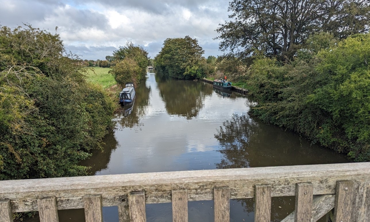
Culham Cut, a stretch of canal built in the early 19th century to aid navigation on the Thames:
Modern settlement edge of Drayton seen across large open arable fields:

×![]()
Modern settlement edge of Drayton seen across large open arable fields:
Open arable fields with electricity infrastructure (near Sutton Courtenay):

×![]()
Open arable fields with electricity infrastructure (near Sutton Courtenay):
Description
Natural (landform, water, semi-natural land cover)
- Underlying geology comprises Ampthill Clay Formation, Kimmeridge Clay Formation Mudstone, and Gault Formation Mudstone bedrock geology, with alluvium clay, silt, sand and gravel superficial deposits associated with the river channel.
- An area of relatively flat river floodplain lying around 50 metres Above Ordnance Datum (AOD), associated with the River Thames. Ditches and tributary watercourses drain the low-lying area flowing north towards the Thames.
- Semi-natural habitats include small deciduous woodlands scattered across the area, as well as notable areas of floodplain grazing marsh along the River Thames. The lowland meadow at Kelaart’s field near Milton forms an important green gap in the built-up landscape.
- Restored areas of gravel extraction and quarrying include rough grassland, scrub, new hedges, and young woodland planting, as well as lakes formed from former gravel extraction. Tree cover is relatively extensive along watercourses, with broad tree belts, thick hedgerows along agricultural field boundaries, and riparian vegetation along the Thames, including willow, poplar and alder. There are distinctive tree groups within pasture to the north of Appleford.
Cultural/social (land use, settlement, infrastructure, historic character)
- Land use is mixed, comprising an irregular pattern of pastoral fields, waterside meadows and pasture along the floodplain. Smaller arable fields abut the eastern edge of Sutton Courtenay, their well-vegetated boundaries providing some buffering between the settlement and quarrying activity. Field boundaries vary, but the majority are low, thick out-grown hedges with occasional mature trees. The A34 dual carriageway is well screened by tree belts, and there is some tree cover associated with the edges of settlements.
- This is a well settled landscape, located between the industrial edge of Didcot (at Milton Park) to south and the town of Abingdon to the north. Sutton Courtenay is a largely linear village occupying almost all of the gap between Didcot and the River Thames, with the smaller village of Culham in turn lying between Sutton Courtenay and Abingdon, separated from both by floodplain. Drayton occupies much of the gap between Abingdon and Milton, and there are pockets of scattered development in particular between Drayton and Sutton Courtenay. Further east, the village of Appleford has ribbon development to the south, whilst Didcot is expanding northwards (the Didcot North East strategic allocation).
- Gravel workings and landfill have altered the landscape, through earthworks and lakes formed from former extraction pits. Other modern land uses include a sewage works, allotments, sports ground and playing fields south of Abingdon. There is a golf course between Milton and Drayton.
- Small-scale manor houses and their associated parklands are found at Milton (Grade I Listed manor house), Sutton Courtenay (Grade I Listed Norman hall and Grade II* Listed manor house) and Culham (Grade II* Listed manor house). The settlements are also covered by Conservation Areas and contain a number of Listed Buildings. Only Sutton Courtenay Manor is a Registered Park and Garden (RPG), although a parkland character remains at Milton and Culham. A strong local vernacular of red brick and tile remains, despite modern extensions to the villages.
- A number of former settlement sites are recorded as Scheduled Monuments, and show the long history of settlement on this floodplain.
- Public rights of way provide access across the area, including the Thames Path National Trail and Vale Way long distance path; National Cycle Network Route 5 crosses north-south through the east.
- The majority of the fieldscapes are of modern origin with limited time depth, having been subject to amalgamation. Fields to the west of Sutton Courtenay are identified as reorganised enclosure, dating to the medieval period.
- Road and rail corridors cut through the area, including the A34 dual carriageway which passes through the south-west, and the Great West Mainline railway line through the south. Recent electrification of the railway has added large-scale overhead electrification infrastructure, which combined with electricity pylons add large vertical elements to the skyline.
Perceptual (views, tranquillity, associations)
- Significant human influence of settlement, quarrying and transport infrastructure within the landscape, and views to the adjacent industrial areas at Milton Park and Didcot limits the sense of tranquillity and remoteness across the majority of this landscape. Despite demolition of the cooling towers and main chimney of the former Didcot Power Station, a number of industrial buildings are still visible.
- Views within and out of the area are frequently obscured by vegetation and mature trees. There are glimpsed views of the Corallian Limestone Ridge on the horizon in views to the north, and in the west there are views northward to Boars Hill and east to Wittenham Clumps.
- There are pockets of tranquillity along the Thames and its floodplain where tree cover gives a degree of peace and isolation. However, nearby human influence, including filtered glimpses of adjacent settlement, electricity pylons and on-going gravel extraction in the south-east, limits the overall sense of remoteness. The Tranquillity Assessment for South Oxfordshire and Vale of White Horse categorises much of the LCA in Zone 1 (‘areas of high tranquillity’) but 16% in Zone 4 (‘areas of low tranquillity’).
- Proximity to Abingdon, Didcot, commercial / industrial development at Milton Park Estate and Didcot, and lighting along the major roads introduces light pollution. Less than 50% of this landscape is categorised as within the darkest 2 bands in the Dark Skies Assessment for South Oxfordshire and Vale of White Horse.
Valued qualities
- Priority habitats floodplain grazing marsh, lowland meadows and deciduous woodland add to landscape character and provide ecological value. Regenerated areas of scrub and woodland habitat improve the character of former gravel extraction sites.
- The pastoral character along watercourses due to the smaller-scale irregular field pattern along the floodplain, riparian vegetation and floodplain grazing marsh and lowland meadows which contribute positively to the landscape.
- Tree cover around settlement edges and along watercourses, with broad tree belts, thick hedgerows along agricultural field boundaries creates a well-wooded character, integrates settlement edge and provides some visual screening.
- Provides an immediate setting to settlements, including the historic estate at Culham, Sutton Courtenay and Milton, containing clusters of Listed Buildings and covered by Conservation Area designations.
- Historic features representing a range of time depths, including prehistoric settlement sites, medieval field patterns, and historic manor houses with associated designed grounds.
- Recreational access to the landscape via a network of public rights of way, including the Thames Path National Trail, National Cycle Network Route 5 and Oxford Greenbelt Way long distance footpath.
- The sense of tranquillity experienced along the river and floodplain, in contrast to the busy suburban edge of Abingdon.
- Open landscape forms gaps between settlements, helping to retain the individual identities of Drayton, Sutton Courtenay, Culham and Appleford.
- Land east of Appleford is more open and rural, and is included within the Appleford to Long Wittenham Local Landscape Designation.
Forces for change
- Past and current mineral extraction has altered the natural topography and land use, with current extraction having an impact on tranquillity.
- Loss of hedges and fragmentation of the hedgerow network along field boundaries and the decline in numbers of hedgerow trees and riparian vegetation along ditches affects the well-wooded character and sense of enclosure.
- Agricultural intensification, diversification and amalgamation of fields into lager parcels of arable land, affecting the landscape pattern and smaller-scale pastoral fields along watercourses.
- Increase in horse grazing and associated facilities, changing the agricultural character.
- Increased recreation along the Thames Path and Oxford Greenbelt Way, which may lead to a demand for greater visitor facilities, altering the rural character.
- Pressure for increased development on the edges of Drayton and Sutton Courtenay (including as part of the East Sutton Courtenay Strategic Allocation) which would affect the rural character of the surrounding landscape and the setting it provides to the historic cores. Increased development pressure in neighbouring towns of Abingdon and Didcot (including as part of the Didcot Power Station and Didcot North East Strategic Allocations) may also impact on views from the vale.
- Settlement gaps in this area are narrow so there is a danger of perceived coalescence if gaps become narrower – for example between Abingdon and Drayton, Drayton and Steventon, Milton and Sutton Courtenay, and Sutton Courtenay and Drayton.
- Plans for new road building and upgrades between Milton, Didcot, Appleford and Culham Science Park (to the north), including a new river crossing, will introduce further human disturbance into the landscape.
- The Lower Vale landscapes may be susceptible to the impacts of climate change, including:
- Deciduous woodlands are facing decline due to warmer winters, altered rainfall patterns, drier summers and increased frequency of extreme events; there may be a shift in vegetation type and composition, increased competition from invasive species, greater numbers of insect and mammal pests, a greater risk of infection by various soil and water-borne pathogens, and a greater risk of wind-throw and loss of mature trees.
- Drier summers and wetter winters may lead to increased mortality and die-back of certain hedgerow tree species; an increased occurrence of insect pests and pathogens could lead to a potential loss or significant reduction in populations of key hedgerow tree species; and increased storm activity may lead to the loss of mature and veteran trees within hedgerows.
- Wetter winters may mean woody species in hedgerows are exposed to prolonged flooding in the growing season and will be at risk of dying, and winter trimming will become more difficult due to wet ground (preferred to autumn trimming to ensure food supply for birds).
- Intensification of adjacent land use leading to increased impacts on hedgerows such as pesticide drift and nutrient enrichment.
- Hotter drier summers and wetter winters and winter flooding could result in changes to wetland and riparian plant community composition; some non-native species may become invasive, and other currently geographically restricted species may spread more easily.
- Wetter winters and higher peak river flows may lead to increased flood defence activity, creating more physical habitat degradation and introducing potentially detracting features.
- Hotter, drier summers and wetter winters will lead to changes in food production and growing seasons, and are likely to cause heat stress to livestock. Flooded land is only capable of supporting lower-value crops, pasture or woodland, which would impact important arable crops. Landscape appearance will likely also be altered, particularly if relocation of growing areas is required or crop diversification occurs (causing a need for changes in field pattern and the potential removal of field margins, hedgerows, woodlands).
Landscape strategy and guidelines
Maintain the open rural character of the landscape, which provides a setting to, and forms gaps between, settlements, including the more historic villages.
- Maintain perceived separation between settlements, avoiding further ribbon development on connecting roads and retaining open rural views across gaps.
- Any new development should use materials which are in keeping with, or complement, the local vernacular of brick and tile.
- Respect the setting to Conservation Areas and sensitivity of historic settlement edges, by resisting changes to the landscape which are not in keeping with the landscape character, including intensive equestrian activities and unsympathetic housing developments.
- Maintain the valued recreational use of the landscape and consider opportunities to introduce additional public rights of way connectivity to enhance appreciation of views and landscape character.
- Consider the impact of lighting on night-time views (refer to the guidance in the Dark Skies Assessment for South Oxfordshire and Vale of White Horse). Encourage initiatives to reduce light pollution in the area.
Historic parklands, and the historic value and landscape diversity they provide, should be conserved and enhanced.
- Conserve and manage historic parkland at Milton, Culham and Sutton Courtenay RPG. Replant key ornamental tree species to retain the parkland character where necessary.
Retain the pastoral character along watercourses by strengthening the smaller-scale irregular field pattern and conserving and enhancing areas of floodplain grazing marsh and riparian vegetation and the ecological value they provide. Consider opportunities to enhance the ecological value and appearance of intensively farmed arable land.
- Manage grazing marsh habitats to enhance their biodiversity value and appearance; ensure best practice management through suitable grazing regimes and avoiding agrochemical and fertiliser inputs; manage recreational routes to avoid/minimise disturbance; and manage scrub vegetation appropriately to maintain the open character.
- Conserve and enhance wetland habitats, including riparian vegetation, to enhance their contribution to landscape character and their nature conservation and biodiversity value.
- Encourage adjacent land uses which strengthen role as ecological corridors and enhance landscape character.
- Seek opportunities to enhance connectivity with other habitats nearby by creating green corridors and networks.
- Manage arable land to enhance its biodiversity value and connectivity, by maintaining and expanding the area of land available for uncultivated arable field margins; seek to maximise the diversity of margins to provide a range of habitats and to assist in the movement of species through the landscape and include species and cultivars that are able to tolerate and flower under hotter, drier summers.
Woodland cover should continue to provide ecological value and help to limit the urbanising visual influence of adjacent settlements, and create a sense of tranquillity along the rivers.
- Retain and enhance tree cover along watercourses, woodland belts, scattered deciduous woodlands, and broad tree belts and thick hedgerows.
- Encourage the appropriate management of woodland, including to reduce the impacts of pests and diseases and to increase its age structure and structural heterogeneity. Consider the promotion of natural colonisation adjacent to existing woodland, allowing locally native species to develop resilience to the pressures of climate change through natural processes.
- Explore opportunities to expand and connect existing woodland and tree cover through natural regeneration or small-scale planting, particularly around settlements. This will strengthen landscape character and bring benefits for biodiversity.
- Seek to prevent further loss or decline in the quality of remaining boundary hedgerows and encourage their restoration/reinstatement; when establishing new hedges, aim to diversify the range of species and select species and provenances adapted to a wider range of climatic conditions.
- Use trees and woodland to integrate development into the landscape.
LCA 13C: East Thames Lower Vale
It should be noted that the lines used to denote where LCAs border settlements are approximate and should not be used for planning purposes.
LCA 13C - View the map full screen in a new tab
Character Area Summary and Location
Low-lying land on the border between Vale of White Horse and South Oxfordshire districts, rising gently as it extends eastwards from the settled floodplain south of Abingdon. The LCA is contained by the Middle Vale (LCA 12C) to the west, the Corallian Limestone Ridge (LCAs 7C and 7D) to the north, and by the outlying Sinodun Hills to the south (LCA 10A). Small areas alongside the River Thames on the southern edge of the LCA fall within the North Wessex Downs National Landscape.
Key characteristics
- A flat, low-lying landscape associated with the River Thames and River Thame and several of their small tributaries; underlain by clay and alluvium near the river channels but better-drained gravel terraces elsewhere.
- Land use is predominantly arable, although there are some areas of smaller-scale pasture generally concentrated on the wetter, poorly draining land adjacent to the river.
- Widespread semi-natural habitats, which include extensive floodplain grazing marsh, lowland meadows, lowland fens and semi-improved grassland.
- Sparsely wooded, enabling long views across the landscape towards the surrounding hills. However, riparian woodland along the rivers and other small pockets of woodland result in a local sense of enclosure.
- Settlements are generally located close to watercourses, many of which retain a substantial number of Listed Buildings and have Conservation Areas; the local vernacular includes timber framing and thatched roofs with occasional examples of cob walling. The ‘new’ village at Berinsfield, created in the 1960s, has a more modern urban influence.
- A dense network of public rights of way enables recreational access to the landscape, including the Shakespeare’s Way long distance footpath and Thames Path National Trail.
- An overall rural character with some intrusion of 20th century built form around Berinsfield, including a recent solar farm development, and at Culham Science Centre. Busy transport corridors such as the A4074, A329 and A4130 cross the area.
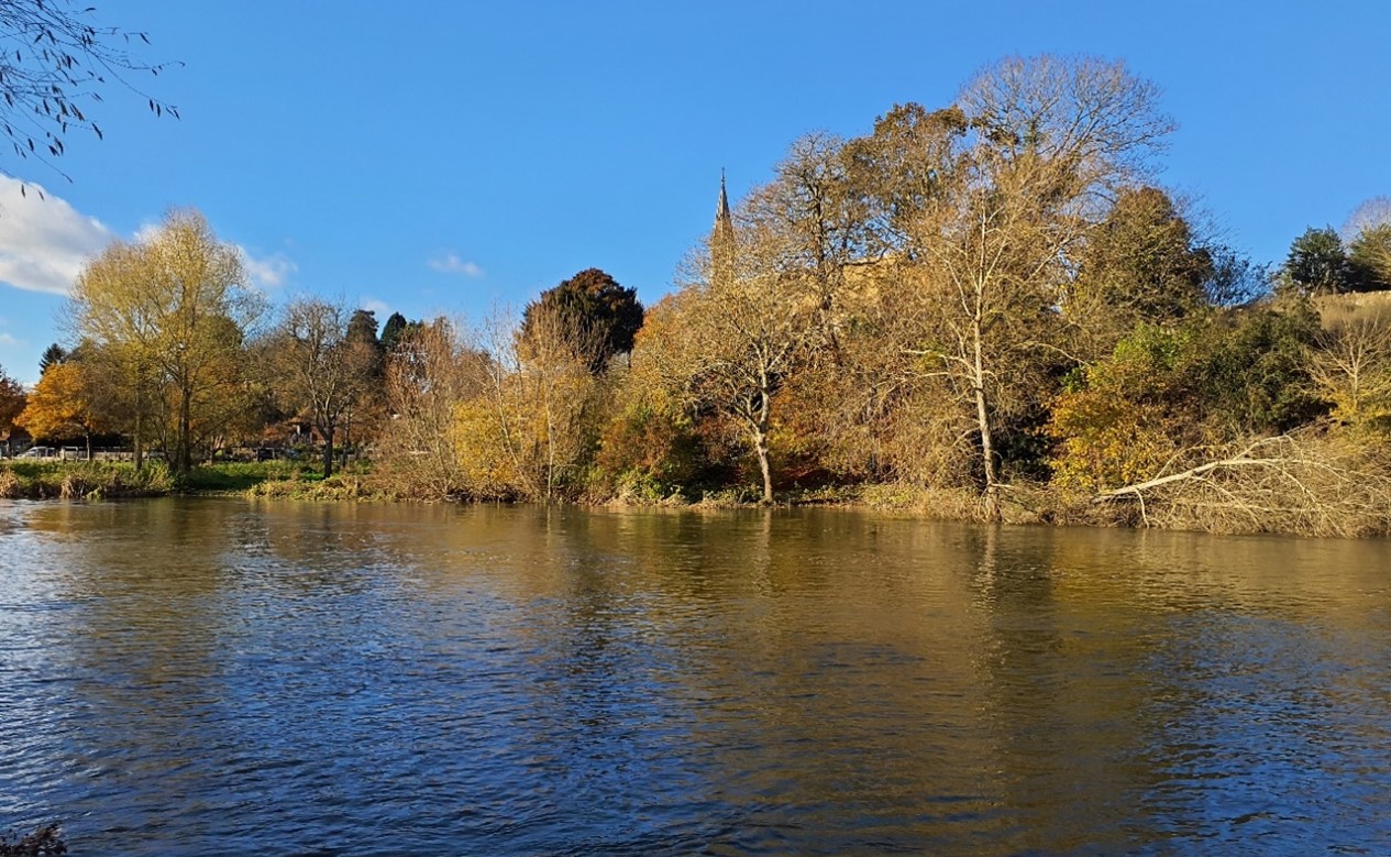
Church spire of St Michael’s & All Angels Church visible above riparian vegetation on the River Thames:
×![]()
Church spire of St Michael’s & All Angels Church visible above riparian vegetation on the River Thames:
Views to Wittenham Clumps:

×![]()
Views to Wittenham Clumps:
One of the lakes between Dorchester and Berinsfield provides recreational value as a watersports centre:

×![]()
One of the lakes between Dorchester and Berinsfield provides recreational value as a watersports centre:
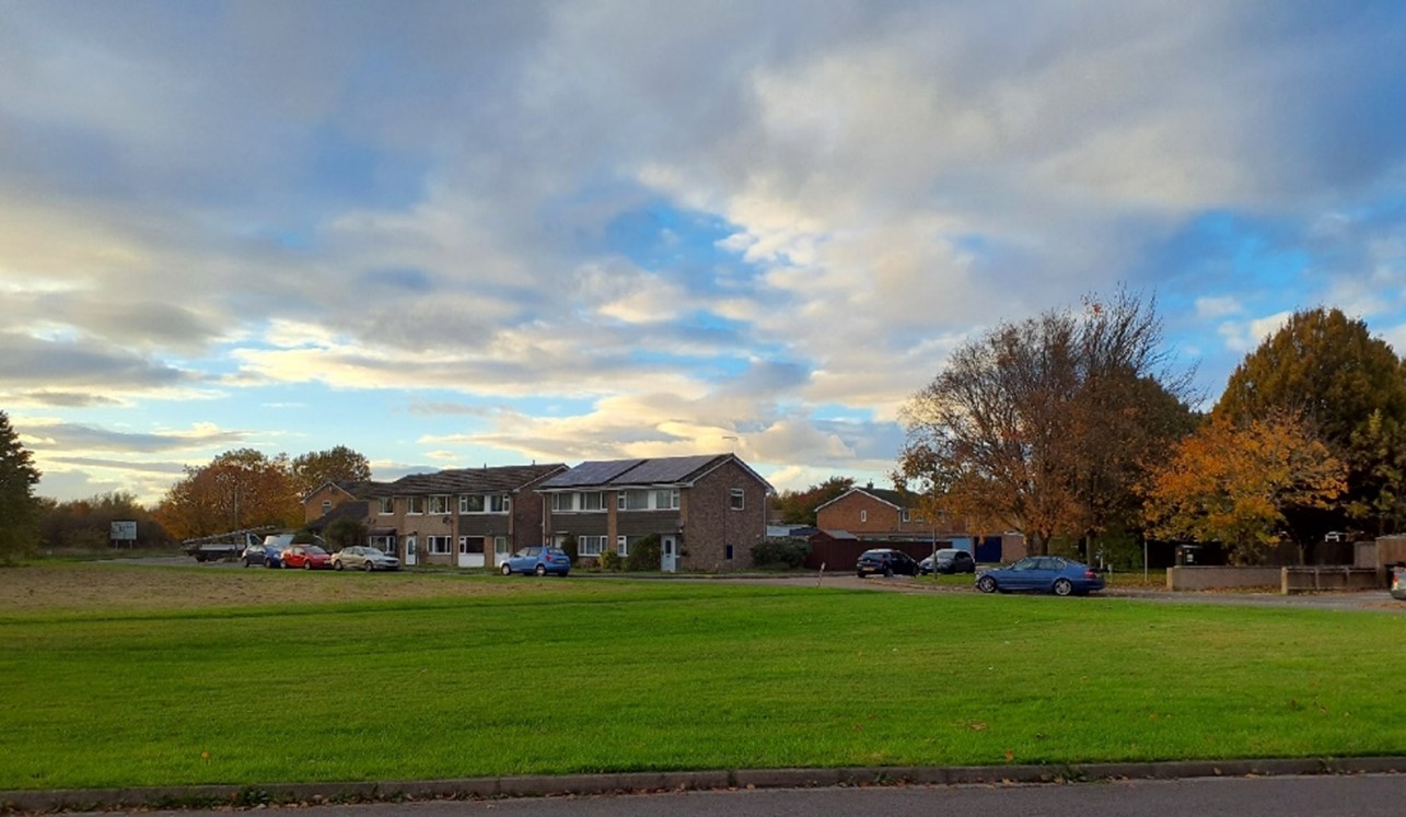
20th century built form around Berinsfield contrasts with rural character:
×![]()
20th century built form around Berinsfield contrasts with rural character:
Description
Natural (landform, water, semi-natural land cover)
- Flat, low-lying topography lying between 50 and 60 metres Above Ordnance Datum (AOD), much of it associated with the River Thames and River Thame floodplains.
- Gault Clay underlies the river corridor; a thin layer of alluvium along the water courses resulting in heavy soils with naturally impeded drainage.
- Away from the rivers, river terrace gravels support lighter soils. As a result, much of the floodplain has been drained and is now under intensive arable cultivation.
- The River Thames flows from Culham to Long Wittenham before heading north to Clifton Hampden. It then arches eastward, passing Burcot, before heading south to Little Wittenham and Shillingford.
- The River Thame flows south past Drayton St Leonard, converging with the River Thames south of Dorchester. A network of smaller watercourses and drainage ditches vein the farmed landscape.
- Former gravel quarries have been filled in as lakes, giving Dorchester the appearance of sitting on an island, with scattered small ponds and pools elsewhere. There is a series of reservoirs to the south-east of Shillingford.
- Wetland priority habitats are widespread in this area, including floodplain grazing marsh, lowland meadows, lowland fens, semi-improved grassland and deciduous woodland.
- Woodland typically occurs in scattered linear blocks within the farmed land. Some larger planted areas occur, for example at Paradise Wood. Riparian vegetation contributes to the woodland cover, with willow common. Ancient Woodland exists in small areas.
Cultural/social (land use, settlement, infrastructure, historic character)
- Land use is predominantly arable, although some smaller-scale areas of pasture are generally concentrated on the wetter, poorly draining land adjacent to the river.
- Species-rich hedgerows are distributed across the landscape. Tree-lined roads are a distinctive feature, such as along Little Wittenham Road.
- Settlements are generally located close to watercourses on terrace gravels, which have been favoured for settlement since prehistoric times due to the lighter, more workable soils, accessible water supply, and slight elevation above the most flood-prone areas. There are relatively small gaps on the north side of the Thames between Clifton Hampden, Burcot, Berinsfield and Dorchester, and across the floodplain of the River Thame between Chiselhampton and Stadhampton.
- A number of ancient settlement sites are designated as Scheduled Monuments, including a large area at Northfield Farm, north-east of Long Wittenham. Dorchester is a Roman settlement of notable significance as one of two walled Roman towns known in Oxfordshire.
- Many of the settlements retain a substantial number of historic buildings and have Conservation Areas. Due the lack of local building stone, most of the older houses are timber framed with thatched roofs and there are occasional examples of cob walling. Brick appears as ‘nogging’ for timber framed houses, in alternating bands of brick and flint in some eighteenth-century cottages and in a characteristic pattern of mellow red and grey brickwork such as in Dorchester. There are historic bridges across the Thames at Shillingford and Clifton Hampden.
- The character area is served by a dense network of public rights of way enabling recreational access to the landscape, including the Shakespeare’s Way long distance footpath and Thames Path National Trail. The former quarry lakes around Dorchester are used for a various recreational uses including fishing, sailing, water skiing and open water swimming. The Thames is navigable, and a number of locks and jetties are found along its length.
- Electricity pylons cross the landscape, adding vertical elements to the skyline.
Perceptual (views, tranquillity, associations)
- The area has an overall rural character with some intrusion of 20th century built form at Berinsfield, including a recent solar farm development, and at the Culham Science Centre.
- The landscape is strongly influenced by the River Thames, which creates coherence in the landscape.
- The flat landform typically enables long distance views across arable farmland, although strong vegetation cover forms a more enclosed character around Burcot and north of Wittenham Clumps. Intervisibility is generally low along the river corridors due to riparian vegetation.
- Despite some visual and aural detraction from busy transport corridors, including the A4074, A329 and A415 roads and part of the Great Western main line, the area is generally relatively tranquil. Factors such as the absence of light pollution, and the visibility of woodland and watercourses contribute to the Tranquillity Assessment for South Oxfordshire and Vale of White Horse categorising 93% of the LCA in Zone 2 (‘areas of some tranquillity’). 75% of the area is categorised in the darkest assessment band in the Dark Skies Assessment for South Oxfordshire and Vale of White Horse.
- There are strong views across the Lower Vale landscape from Round Hill, one of the twin peaks which make up the Wittenham Clumps.
Valued qualities
- Little Wittenham village and fields near the Thames north of the village, and also the floodplain fields west of Shillingford between the Thames and Wittenham Clumps, are designated as part of the North Wessex Downs National Landscape. This largely reflects their strong visual relationship with Wittenham Clumps, one of the key recreational viewpoints in the National Landscape.
- The wider LCA forms part of the rural, northern setting of the National Landscape, having some intervisibility with the designated area, in particular Wittenham Clumps.
- The presence of widespread semi-natural habitats, including small pockets of Ancient Woodland and priority habitat floodplain grazing marsh, lowland meadows, lowland fens, semi-improved grassland and deciduous woodland; these features provide ecological value and contribute positively to the landscape.
- Species rich hedgerows provide ecological corridors and landscape structure within the farmed landscape.
- Locally distinctive pattern of tree-lined roads.
- Recreational access to the landscape via a network of public rights of way, including the Shakespeare’s Way long distance footpath and Thames Path National Trail. Water-based recreation along the River Thames.
- Open landscape forms gaps between the settlements, helping to retain their individual identities.
- Provides a rural setting to settlements, many of which retain a number of Listed Buildings and have Conservation Areas; distinctive local vernacular includes the use of timber framing and thatched roofs with occasional examples of cob walling.
- Sense of time-depth also due to the presence of ancient settlement sites designated as Scheduled Monuments.
- Open views are available across much of the landscape, including south towards the distinctive Wittenham Clumps.
- Riparian woodland cover along the rivers results in a pastoral character and a greater sense of enclosure.
- An overall rural character and sense of tranquillity in areas away from modern intrusion.
- The value of the area centred on the loop of the Thames between Dorchester and Appleford is demonstrated by its inclusion within the Appleford to Long Wittenham Local Landscape Designation.
Forces for change
- Loss of hedges and fragmentation of the hedgerow network along field boundaries and a decline in numbers of hedgerow trees and riparian vegetation along ditches. This increases the sense of openness and could affect the greater sense of enclosure along the rivers.
- Agricultural intensification, diversification and amalgamation of fields into larger parcels of arable land, affecting the landscape pattern and reducing the extent of smaller-scale pastoral fields along watercourses.
- Restoration of ancient channels, ponds and riparian habitats along the River Thames between Clifton Hampden and Little Wittingham, through the River of Life scheme, will provide greater biodiversity and a more natural river channel.
- Increase in horse grazing and associated facilities, changing the agricultural character.
- Recent introduction of solar farm developments, including to the north of Dorchester, has changed the traditional agricultural land use and has a localised impact on views across the landscape. The drive for Net Zero is resulting in proposals for further solar developments on the vale, including to north-east of Clifton Hampden.
- Pressure for increased development on the edges of Long Wittenham, Dorchester, Warborough and Berinsfield (including as part of the Land at Berinsfield Strategic Allocation) which would affect the rural character of the surrounding landscape and the setting it provides to the North Wessex Downs National Landscape.
- Increased development pressure in the adjacent Culham Science Centre (as part of the Culham Science Centre Strategic Allocation) and on the northern edge of Didcot (as part of the Didcot North East Strategic Allocation) and north-western edge of Benson, would also impact on views across the vale.
- Plans for road improvements between Milton, Didcot, Appleford, Culham Science Park, passing north of Clifton Hampden including a new river crossing, will introduce further human disturbance into the landscape.
- Pressure for mineral extraction around Clifton Hampton which would impact the rurality and tranquillity of the landscape.
- The Lower Vale landscapes may be susceptible to the impacts of climate change, including:
- Deciduous woodlands are facing decline due to warmer winters, altered rainfall patterns, drier summers and increased frequency of extreme events; there may be a shift in vegetation type and composition, increased competition from invasive species, greater numbers of insect and mammal pests, a greater risk of infection by various soil and water-borne pathogens, and a greater risk of wind-throw and loss of mature trees.
- Drier summers and wetter winters may lead to increased mortality and die-back of certain hedgerow tree species; an increased occurrence of insect pests and pathogens could lead to a potential loss or significant reduction in populations of key hedgerow tree species; and increased storm activity may lead to the loss of mature and veteran trees within hedgerows.
- Wetter winters may mean woody species in hedgerows are exposed to prolonged flooding in the growing season and will be at risk of dying, and winter trimming will become more difficult due to wet ground (preferred to autumn trimming to ensure food supply for birds).
- Intensification of adjacent land use leading to increased impacts on hedgerows such as pesticide drift and nutrient enrichment.
- Hotter drier summers and wetter winters and winter flooding could result in changes to wetland and riparian plant community composition; some non-native species may become invasive, and other currently geographically restricted species may spread more easily.
- Wetter winters and higher peak river flows may lead to increased flood defence activity, creating more physical habitat degradation and introducing potentially detracting features.
- Hotter, drier summers and wetter winters will lead to changes in food production and growing seasons, and are likely to cause heat stress to livestock. Flooded land is only capable of supporting lower-value crops, pasture or woodland, which would impact important arable crops. Landscape appearance will likely also be altered, particularly if relocation of growing areas is required or crop diversification occurs (causing a need for changes in field pattern and the potential removal of field margins, hedgerows, woodlands).
Landscape strategy and guidelines
Consider the role of southern areas of this area as part of the North Wessex Downs National Landscape.
- Conserve and enhance the distinctive pattern of elements (including river valleys with grazed pastures, water meadows and wetlands; mixed fields and arable production; different types of woodland; and arable habitats) which contributes positively to the character and special qualities of the National Landscape.
- Consider impact of development on both close and distant views from the National Landscape, and how any new development would impact on the setting of the National Landscape.
Maintain the open rural character of the landscape, which provides a setting to, and forms gaps between, settlements, including the more historic villages.
- Retain the distinct character of each settlement. Avoid any perceived coalescence due to roadside ribbon development between the riverside settlements.
- Any new development should use materials which are in keeping with, or complement, the local vernacular of timber-framing, thatched roofs, and brick and flint banding.
- Respect the setting to Conservation Areas and sensitivity of historic settlement edges, by resisting changes to the landscape which are not in keeping with the landscape character, including intensive equestrian activities and unsympathetic housing developments.
- Consider the impact of lighting on night-time views (refer to the guidance in the Dark Skies / Light Impact Assessment for South Oxfordshire and Vale of White Horse).
- Consider impact of development on both close and distant views from the North Wessex Downs National Landscape, and how any new development would impact on the special qualities of the National Landscape.
- Refer to the South Oxfordshire and Vale of White Horse Renewable Energy Study when considering any solar panel applications. Consider the impact on views of the solar arrays from the surrounding higher ground, and the cumulative impact of further solar development.
- Maintain the valued recreational use of the landscape and consider opportunities to introduce additional public rights of way connectivity to enhance appreciation of views and landscape character.
- Conserve the distinctive pattern of tree-line roads, ensuring that their character is not lost through unsympathetic highway works, unnecessary signage, lighting, or removal of hedgerows and trees.
Retain and enhance the pastoral character along floodplains by strengthening the smaller-scale field pattern and conserving and enhancing areas of wetland habitats and riparian vegetation and the ecological value they provide. Ensure that any proposals as part of the ‘River Of Life II’ or other similar schemes are sensitively designed. Consider opportunities to enhance the ecological value and appearance of intensively farmed arable land.
- Conserve and enhance floodplain grazing marsh, lowland meadows, lowland fens, semi-improved grassland and riparian vegetation, to enhance their contribution to landscape character and their nature conservation and biodiversity value.
- Manage grazing marsh habitats to enhance their biodiversity value and appearance; ensure best practice management through suitable grazing regimes and avoiding agrochemical and fertiliser inputs; manage recreational routes to avoid/minimise disturbance; and manage scrub vegetation appropriately to maintain the open character.
- Encourage adjacent land uses which strengthen role as ecological corridors and enhance landscape character.
- Seek opportunities to enhance connectivity with other habitats nearby by creating green corridors and networks, including woodland on the limestone ridges to the north, and North Wessex Downs National Landscape to the south.
- Manage arable land to enhance its biodiversity value and connectivity, by maintaining and expanding the area of land available for uncultivated arable field margins; seek to maximise the diversity of margins to provide a range of habitats and to assist in the movement of species through the landscape and include species and cultivars that are able to tolerate and flower under hotter, drier summers.
- Carefully consider any new applications for boathouses or jetties along the Thames, to retain the naturalistic character of the river, while ensuring it retains its recreational value.
Maintain existing woodland cover and look to increase this to provide ecological value and help to limit the urbanising influence of development and busy roads, whilst maintaining characteristic open long views across the landscape.
- Explore opportunities to expand and connect existing woodland and tree cover through natural regeneration or small-scale planting, particularly around settlements. This will strengthen landscape character and bring benefits for biodiversity.
- Encourage the appropriate management of woodland, including to reduce the impacts of pests and diseases and to increase its age structure and structural heterogeneity. Consider the promotion of natural colonisation adjacent to existing woodland, allowing locally native species to develop resilience to the pressures of climate change through natural processes.
- Seek to prevent further loss or decline in the quality of remaining boundary hedgerows and encourage their restoration/reinstatement; when establishing new hedges, aim to diversify the range of species and select species and provenances adapted to a wider range of climatic conditions.
- Maintain and enhance existing tree cover along roads.
- Use trees and woodland to integrate development into the landscape.
LCA 13D: South Thames Lower Vale
It should be noted that the lines used to denote where LCAs border settlements are approximate and should not be used for planning purposes.
LCA 13D - View the map full screen in a new tab
Character Area Summary and Location
Low-lying land on the Thames floodplain on the boundary between Vale of White Horse and South Oxfordshire districts. The LCA is located between Didcot and Wallingford, encircled by the higher ground of the Sinodun Hills to the north (LCA 10A), the Wessex Downs scarp and footslopes to the south (LCA 9D), and the Chiltern escarpment footslopes to the east (LCA 9E). Much of the LCA is in the North Wessex Downs National Landscape, and a small area on the eastern side of the River Thames falls within the Chilterns National Landscape.
Key characteristics
- A low-lying, gently undulating landform to the west of the River Thames; crossed by several small watercourses that feed the Thames, including Hakka’s Brook, Mill Brook and Kibble Ditch.
- Cholsey Hill is an isolated chalk and greensand outcrop that forms a local landmark rising from the floodplain.
- A rural agricultural landscape of predominantly open large-scale arable farming, albeit with some smaller-scale permanent pasture concentrated in wetter areas next to the River Thames; hedgerow field boundaries are fragmented or missing in places which reinforces the open character.
- Limited tree cover enables high intervisibility and extensive open views, including south towards the chalk escarpment of the North Wessex Downs and to the edge of the Chilterns National Landscape. Riparian woodland and smaller-scale field pattern along the river and other watercourses results in a greater sense of enclosure and intimacy.
- Settlement pattern of small, nucleated villages, with clusters of Listed Buildings, and many with designated Conservation Areas ; the local vernacular includes thatch, red brick and weatherboard.
- The Saxon origins of many of the villages, and the important walled burgh of Wallingford, provides evidence of a long history of settlement.
- A well-connected network of public rights of way network enables recreational access to the landscape, including The Ridgeway, The Thames Path National Trails, and a cycle route on the dismantled railway line between Upton and Didcot.
- Predominantly rural, tranquil, character, although busy transport corridors, railway infrastructure and electricity pylons are visual and aural detractors in the landscape.
Cholsey Hill rises in the distance from the low-lying floodplain:
×![]()
Cholsey Hill rises in the distance from the low-lying floodplain:
Priority habitat floodplain grazing marsh lies beside the River Thames at Wallingford:

×![]()
Priority habitat floodplain grazing marsh lies beside the River Thames at Wallingford:
Electricity pylons traverse the open vale (with chalk downland in the distance), near Cholsey:

×![]()
Electricity pylons traverse the open vale (with chalk downland in the distance), near Cholsey:
Horses and horsetape near settlement at East Hagbourne:
×![]()
Horses and horsetape near settlement at East Hagbourne:
Description
Natural (landform, water, semi-natural land cover)
- Datum (AOD), incised by small watercourses which give rise to a gently undulating landform. Cholsey Hill, an isolated outcrop of Greensand and Chalk, forms a distinctive rounded high point at 74 metres AOD, a prominent feature in the flat vale landscape.
- Underlain by alluvium, much of this has been subject to drainage improvements to facilitate intensive arable farming. Permanent pasture is concentrated mainly within wetter areas next to the River Thames.
- The River Thames runs along the eastern edge of the character area, and this is fed by a network of small watercourses including Hakka’s Brook, Mill Brook and Kibble Ditch.
- Tree and woodland cover is sparse, occurring mainly in field boundaries and linear belts around farms (some of which are recorded as priority habitat deciduous woodland). Small pockets of priority habitat traditional orchards are concentrated around farmsteads.
- Wetland priority habitats include lowland calcareous grassland and floodplain grazing marsh. Mowbray Fields Local Nature Reserve (LNR) on the southern edge of Didcot includes a small section of stream, fill pond and wildflower meadow.
Cultural/social (land use, settlement, infrastructure, historic character)
- A predominantly agricultural landscape comprising large-scale arable fields, often with hawthorn hedges. Arable field margins are widespread across this character area. In some places, such as around Cholsey, hedgerow field boundaries are fragmented or missing, reinforcing the open character and expansive views.
- Many of the surviving settlements have Saxon origins and are typically clustered along the foot of the downs, taking advantage of the water supply arising from springs at the junction of the chalk and clay (for example Cholsey). Others are located on isolated pockets of higher ground within the vale, such as Brightwell-cum-Sotwell, Mackney, and North and South Moreton.
- Historic settlement pattern of small, nucleated villages remains, many of which have Conservation Areas. Thatch, red brick and weatherboard are characteristic of the older buildings, sometimes with knapped flint and weathered chalk in their walls. Traditional barns have a similar character. West Hagbourne is mentioned in the Domesday Book.
- Wallingford is the largest settlement in the area, its historic core contains a Conservation Area and a high density of Listed Buildings. It is a Saxon town which retains lengths of its 9th century earthen walls and, within the character area near the riverside, the ruins of its medieval castle (both Scheduled Monuments).
- Busy transport corridors cross through the area including the A4074, A329 and the A4130 roads. Railway infrastructure also crosses the landscape, including the Great Western main line and the Cholsey and Wallingford railway. Electricity pylons and overhead lines cross the skyline to the west of Cholsey.
- The site of the former Fairmile Hospital, now a Registered Park and Garden (RPG), has recently been redeveloped as a residential complex comprising new development among the existing traditional red-brick buildings.
- A well-connected network of public rights of way enables recreational access to the landscape, including The Ridgeway and The Thames Path National Trails. A section of the cycle route along the disused railway between Upton and Didcot and National Cycle Network Route 5 crosses the north-east, passing through Wallingford.
Perceptual (views, tranquillity, associations)
- An open landscape with high intervisibility and extensive open views, including from and towards the chalk escarpment of the North Wessex Downs and edge of the Chilterns National Landscape.
- Large new commercial development on the western edge of Wallingford contributes to the sense of coalescence between Wallingford and Brightwell-cum-Sotwell, eroding the rural character of the area.
- The Electricity pylons form prominent features on the open skylines to the west of Cholsey and are a detractive element in views.
- Smaller-scale, irregular field pattern near Brightwell-cum-Sotwell creates a more enclosed, intimate character.
- Views to the southern edge of Didcot are more open where vegetation is limited.
- Predominantly a rural and relatively tranquil, character, although transport corridors (particularly the A329, A4074, A415 and A329) and infrastructure associated with the railway line are local visual and aural detractors in the landscape. The Tranquillity Assessment for South Oxfordshire and Vale of White Horse categorises 85% of the LCA in Zone 2 (‘areas of some tranquillity’).
Valued qualities
- Much of the LCA falls with the Wessex Downs National Landscape, and the Chilterns National Landscape, and displays many of the special qualities including chalk grasslands, arable habitats, medieval and post-medieval settlements with historic buildings, extensive public rights of way and panoramic views towards the chalk escarpment.
- The Thames river valley is a nationally famous landscape and is partially designated as part of both the North Wessex Downs and the Chilterns National Landscapes.
- A rolling agricultural landscape that forms part of the rural setting of the North Wessex Downs National Landscape and Chilterns National Landscape.
- Semi-natural habitats provide ecological value and contribute positively to the landscape, including priority habitat lowland calcareous grassland, floodplain grazing marsh associated with the river, deciduous woodland, and traditional orchards.
- The landscape provides a rural setting to historic settlements, many of which retain a number of Listed Buildings and have Conservation Areas; the landscape influenced their location on the spring line at the foot of the Downs. Distinctive local vernacular includes the use of thatch, red brick and weatherboard.
- Open landscape forms gaps between the various settlements, helping to retain their individual identities and the historic nucleated settlement pattern.
- Areas of open grassland, meadows and orchards contrast with the intensively managed arable land, providing texture and visual interest to the landscape. Remnant areas of orchards also provide links to historic land uses and contribute to historic landscape character, including on the edges of East Hagbourne and Brightwell-Cum-Sotwell.
- Recreational value of the public rights of way network, including The Ridgeway and The Thames Path National Trails.
- Open views towards the chalk escarpment of the North Wessex Downs and edge of the Chilterns. Cholsey Hill forms a prominent local feature rising above the low-lying vale.
- Riparian woodland and smaller-scale field pattern along the river and other watercourses results in pastoral character and a greater sense of enclosure and intimacy.
- The rural character and sense of tranquillity experienced across much of the landscape, particularly away from the edges of Wallingford and Didcot and along vegetated watercourses.
Forces for change
- boundaries and a decline in numbers of hedgerow trees and riparian vegetation along ditches. This increases the sense of openness and could affect the areas with greater sense of enclosure along the rivers and around Brightwell-Cum-Sotwell.
- Agricultural intensification, diversification and amalgamation of fields into lager parcels of arable land, affecting the landscape pattern and reducing the extent of smaller-scale fields along watercourses.
- Increase in horse grazing and associated facilities, changing the agricultural character.
- Recent and proposed introduction of solar farm developments in the surrounding vales (for example to the north of Dorchester and north-east of Clifton Hampden) and the drive for Net Zero may increase pressure for solar developments on the vale. This would change the traditional agricultural land use and have a localised impact on views across the landscape.
- Pressure for increased development on the edges of Wallingford, Cholsey and Brightwell-cum-Sotwell, which would affect the rural character of the surrounding landscape and the setting it provides to their historic cores. Further development between Brightwell-cum-Sotwell and Wallingford may also create the impression of coalescence which would have a localised effect on the characteristic settlement pattern. Increased development pressure on the eastern southern edge of Didcot would also impact on views across the vale and potential diminish the already fragile separation of East Hagbourne.
- The Lower Vale landscapes may be susceptible to the impacts of climate change, including:
- Deciduous woodlands are facing decline due to warmer winters, altered rainfall patterns, drier summers and increased frequency of extreme events; there may be a shift in vegetation type and composition, increased competition from invasive species, greater numbers of insect and mammal pests, a greater risk of infection by various soil and water-borne pathogens, and a greater risk of wind-throw and loss of mature trees.
- Drier summers and wetter winters may lead to increased mortality and die-back of certain hedgerow tree species; an increased occurrence of insect pests and pathogens could lead to a potential loss or significant reduction in populations of key hedgerow tree species; and increased storm activity may lead to the loss of mature and veteran trees within hedgerows.
- Wetter winters may mean woody species in hedgerows are exposed to prolonged flooding in the growing season and will be at risk of dying, and winter trimming will become more difficult due to wet ground (preferred to autumn trimming to ensure food supply for birds).
- Intensification of adjacent land use leading to increased impacts on hedgerows such as pesticide drift and nutrient enrichment.
- Hotter drier summers and wetter winters and winter flooding could result in changes to wetland and riparian plant community composition; some non-native species may become invasive, and other currently geographically restricted species may spread more easily.
- Wetter winters and higher peak river flows may lead to increased flood defence activity, creating more physical habitat degradation and introducing potentially detracting features.
- Hotter, drier summers and wetter winters will lead to changes in food production and growing seasons, and are likely to cause heat stress to livestock.
- Soil moisture deficits and inundation/flooding, as well as changes in temperatures (hotter, drier, longer summers, wetter winters), could lead to changes in food production and growing seasons. Flooded land is only capable of supporting lower-value crops, pasture or woodland, which would impact important arable crops. Landscape appearance will likely also be altered, particularly if relocation of growing areas is required or crop diversification occurs (causing a need for changes in field pattern and the potential removal of field margins, hedgerows, woodlands).
- Changing temperatures and extreme weather events are creating vulnerabilities in chalk grassland landscapes, leading to increased soil erosion and run-off.
- Drier summers and wetter winters could cause changes in plant and animal species and community composition of chalk grassland (for example loss of perennials, expansion of drought-tolerant ephemerals and dominance of grasses in the sward of chalk grassland).
- Drier summers leading to an increased fire risk affecting chalk grassland habitats.
Landscape strategy and guidelines
Consider the role of this area both as part of the North Wessex Downs National Landscape and Chilterns National Landscape, and as an immediate setting to the National Landscapes.
- Conserve and enhance the distinctive pattern of elements (including chalk grasslands, arable habitats, Medieval and post-Medieval settlements with historic buildings, extensive public rights of way and panoramic views towards the chalk escarpment) which contributes positively to the character and special qualities of the National Landscapes.
- Consider impact of development within this landscape on views from the National Landscapes.
Maintain the open rural character of the landscape, which forms gaps between settlements and provides an immediate setting, including the more historic villages.
- Respect the setting to Conservation Areas and sensitivity of historic settlement edges, by resisting changes to the landscape which are not in keeping with the landscape character, including intensive equestrian activity and unsympathetic housing developments. Retain the historic association between settlements and watercourses.
- Any new development should use materials which are in keeping with, or complement, the local vernacular of red brick, weatherboarding and thatched roofs.
- Maintain the valued recreational use of the landscape and consider opportunities to introduce additional public rights of way connectivity, particularly across the railway lines, to enhance appreciation of views and landscape character.
- Consider the impact of lighting on night-time views (refer to the guidance in the Dark Skies Assessment for South Oxfordshire and Vale of White Horse).
- Consider impact of development on both close and distant views from both the North Wessex Downs National Landscape and the Chilterns National Landscape, and how any new development would impact on the special qualities of both.
Watercourses should be maintained and enhanced as distinctive landscape elements with high biodiversity value.
- Conserve and enhance floodplain grazing marsh, lowland calcareous grassland and riparian vegetation, to enhance their contribution to landscape character and their nature conservation and biodiversity value.
- Manage grazing marsh habitats to enhance their biodiversity value and appearance; ensure best practice management through suitable grazing regimes and avoiding agrochemical and fertiliser inputs; manage recreational routes to avoid/minimise disturbance; and manage scrub vegetation appropriately to maintain the open character.
- Encourage adjacent land uses which strengthen role as ecological corridors and enhance landscape character.
- Seek opportunities to enhance connectivity with other habitats nearby by creating green corridors and networks.
- Manage arable land to enhance its biodiversity value and connectivity, by maintaining and expanding the area of land available for uncultivated arable field margins; seek to maximise the diversity of margins to provide a range of habitats and to assist in the movement of species through the landscape and include species and cultivars that are able to tolerate and flower under hotter, drier summers.
Maintain existing woodland cover and look to increase this to provide ecological value and help to limit the urbanising influence of development and busy roads, whilst maintaining characteristic open long views across the landscape. Maintain and enhance areas of remnant orchards and the ecological value, historic character, texture and visual interest they provide.
- Explore opportunities to expand and connect existing woodland and tree cover through natural regeneration or small-scale planting, particularly around settlements. This will strengthen landscape character and bring benefits for biodiversity.
- Encourage the appropriate management of woodland, including to reduce the impacts of pests and diseases and to increase its age structure and structural heterogeneity. Consider the promotion of natural colonisation adjacent to existing woodland, allowing locally native species to develop resilience to the pressures of climate change through natural processes.
- Seek to prevent further loss or decline in the quality of remaining boundary hedgerows and encourage their restoration/reinstatement; when establishing new hedges, aim to diversify the range of species and select species and provenances adapted to a wider range of climatic conditions.
- Use trees and woodland to integrate development into the landscape.
- Encourage the maintenance and restoration of traditional orchards on the edge of settlements and farmsteads, including retention of the remaining older orchard trees which have visual and biodiversity value and enhance a sense of time-depth.