LCT 6: Chalk Escarpment Footslopes
Landscape character type summary
The Chalk Escarpment Footslopes are rolling landscapes which descend gently from the foot of the escarpments of the North Wessex Downs (LCT 1) and Chilterns (LCT 2). Shorter, steeper slopes down to the edges of the vales typically screen the clay lowlands from view, so there is more commonly a relationship with the escarpment to the south, but sometimes also with the distant Midvale Ridge to the north. The sloping landform, combined in places with a lack of significant field boundaries in this largely arable landscape, typically gives the footslopes an expansive character. Tree cover associated with the streams which cut through the landform in places, or where shelter belts or parklands have been created, gives rise to some more intimate areas. In general there are more trees and stronger hedgerows on the slopes beneath the Chiltern escarpment than is the case beneath the Chiltern Hills.
Two Landscape Character Areas (LCA) are identified:
- LCA 6A: Wessex Downs Chalk Escarpment Footslopes
- LCA 6B: Chiltern Chalk Escarpment Footslopes.
LCA 6A: Wessex Downs Chalk Escarpment Footslopes
It should be noted that the lines used to denote where LCAs border settlements are approximate and should not be used for planning purposes.
Character Area Location
A rolling landscape ‘ledge’ south of Wantage which forms a transition between the higher chalk scarp and upper slopes to the south (LCAs 1A and 3A) and the lower vale edge slopes to the north (LCAs 9A and 9B). The LCA is located entirely within the North Wessex Downs National Landscape.
Key characteristics
- A shelf of large-scale rolling open arable farmland, that falls from the foot of the scarp to the south towards the lower-lying vale landscapes to the north.
- A predominantly large-scale, open arable landscape, with field boundaries often absent or defined by gappy hedgerows; smaller parcels of land around settlement edges, including orchards, paddocks, estate lands and remnant parklands, provide greater texture and visual interest.
- Watercourses flow north from chalk springs towards the Rivers Ock and Thames. These form the focus for the historic ‘spring-line villages’, such as Letcombe Regis, Ardington and East Hendred, which are covered by Conservation Areas and contain clusters of Listed Buildings.
- Vegetation is concentrated along the watercourses, with small woodland blocks and planting associated with small estates and parklands at Ardington and East Hendred.
- Straight, narrow roads and lanes cross the footslopes from north to south. The larger A338 and A34 are busy and create noise and movement in an otherwise tranquil and rural landscape.
- Public rights of way connect the small settlements and provide recreational access to the countryside.
- Panoramic, long-distance views across the footslopes and the lower-lying vale to the north, with vegetation at Ardington and East Hendred forming the only barrier. The scarp to the south forms a strong backdrop.
Large-scale open arable fields south of Sparsholt:
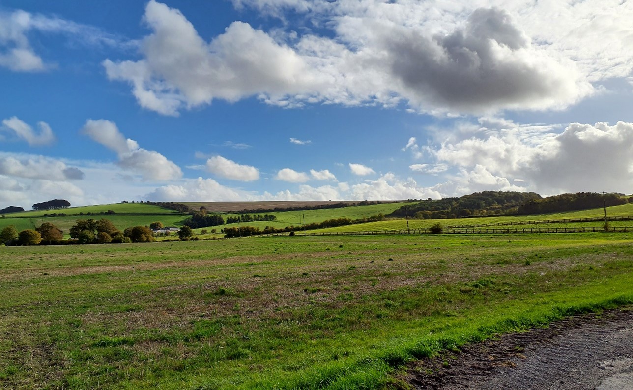
×![]()
Large-scale open arable fields south of Sparsholt:
Straight, narrow roads and lanes cross the footslopes from north to south (near Seven Acre Hill):
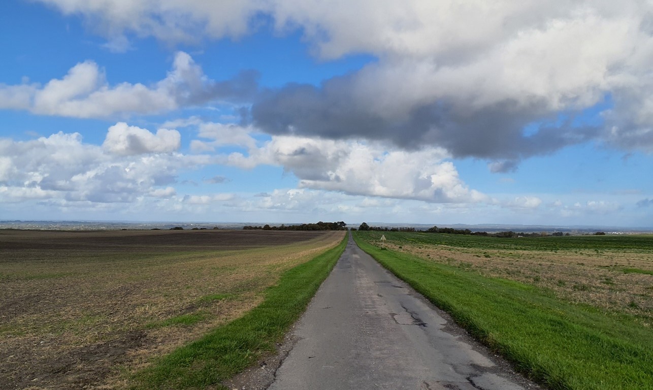
×![]()
Straight, narrow roads and lanes cross the footslopes from north to south (near Seven Acre Hill):
Parkland associated with Hendred Estate at the foot of the scarp slope (south of East Hendred):
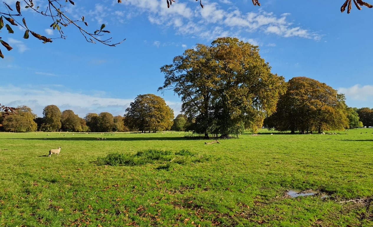
×![]()
Parkland associated with Hendred Estate at the foot of the scarp slope (south of East Hendred):
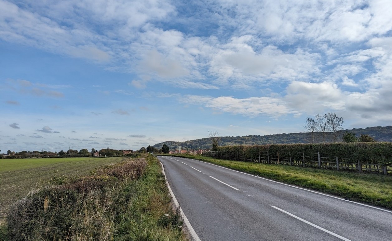
The southern edge of East Challow is partially integrated by trees and woodland:

×![]()
The southern edge of East Challow is partially integrated by trees and woodland:
Description
Natural (landform, water, semi-natural land cover)
- The shelf of rolling landscape is underlain by West Melbury Marly, Holywell Nodular and Zig Zag Chalk Formations, with a band of calcareous sandstone and siltstone of the Upper Greensand Formation in the north as the slopes descend to Wantage and Harwell.
- Minor valley features cut through the landscape, creating an undulating landform, which generally ascends to the south where it meets the foot of the scarp around 140 metres Above Ordnance Datum (AOD).
- Semi-natural vegetation is concentrated along the chalk spring-fed watercourses, including Letcombe Brook, Ginge Brook and Betterton Brook, which flow north and are edged by riparian woodland and vegetation.
- Several small woodland blocks and substantial tree belts, many of which are identified as priority habitat deciduous woodland. There are also a few areas of priority habitat traditional orchard present on the edge of settlements. Tree planting is also associated with remnant parkland, including tree lines along driveways, roundels and large mature trees within fields.
Cultural/social (land use, settlement, infrastructure, historic character)
- The landscape is generally in use for large-scale arable cultivation. Field boundaries are predominantly open due to hedgerow loss; where hedges survive, they include hawthorn and elm. The large open fields are a result of amalgamation of older enclosures. Smaller parcels of land are concentrated at settlement edges and include orchards, paddocks, estate lands and remnant parklands.
- Settlements are located near the source of spring-fed streams below the scarp, known as ‘spring line’ villages. These generally have surviving medieval centres and are often covered by Conservation Areas and contain numerous Listed Buildings.
- The southern edge of Wantage lies to the north, and the Harwell Campus is in the east, although excluded from the LCA. This landscape provides a rural setting to the settlements and campus.
- Roads and lanes cross the footslopes, and are predominantly orientated north-south, including the A338 which runs south out of Wantage and the A34 in the east. These connect the higher downs to the south with the lower-lying vale to the north.
- A section of the dismantled Didcot, Newbury and Southampton Railway curves through a flatter area of footslopes heading towards Compton. Although mainly in cutting, the route is marked by vegetation and remaining brick bridges.
- A network of public rights of way connects settlements, providing recreational access across the landscape, and along watercourses. National Cycle Route 544 runs east-west from Wantage towards Didcot.
- Estates and parklands are a key feature of the landscape, with small manor houses on the edge of most of the villages. None of the parklands are listed, however parkland features including tree roundels and parkland trees are still present. Examples include Arnhill Park and Helena’s Park on the edge of East Lockinge, and Ardington House and its grounds.
- Other features which provide time-depth within the landscape include a Bronze Age Bowl Barrow at Churn Farm in the east and the Anglo-Saxon cemetery at Goldbury Hill(both Scheduled Monuments).
Perceptual (views, tranquillity, associations)
- The open and undulating nature of the footslopes facilitates panoramic, long distance, views. These include views across the lower lying landscape to the north; views of the scarp, which forms a backdrop to the south; as well as views across the footslopes themselves, largely unimpeded by tree cover.
- A rural, relatively tranquil area, with a sense of exposure on the open slopes; this provides a setting to the towns and villages to the north, and the scarp to the south. Some detracting influence of recent and ongoing development on the eastern edge of Wantage (Crab Hill Strategic Allocation).
- Tree cover combined with undulating topography provides some areas of enclosure and a stronger sense of tranquillity. The Tranquillity Assessment for South Oxfordshire and Vale of White Horse categorises 23% of the LCA in Zone 1 (‘areas of high tranquillity’) and 71% in Zone 2 (‘areas of some tranquillity’). Away from Harwell Campus there is a good experience of dark night skies, with over 60% of the area lying within the darkest of the bands identified in the Dark Skies Assessment for South Oxfordshire and Vale of White Horse.
- Settlement is assimilated relatively well into the landscape by tree cover. However, pylons which cross the east corner of the LCA, major roads, and modern buildings at Harwell Campus undermine the sense of remoteness.
Valued qualities
- Located entirely within the North Wessex Downs National Landscape and displays many of the special qualities including chalk streams, arable habitats, medieval settlements with historic buildings, country houses and landscape gardens and extensive public rights of way.
- A rolling landscape, which is prominent below the Downs scarp in views from the lower-lying vale, provides a rural backdrop to settlements in the north.
- Spring-fed chalk streams run north through the foothills, with riparian vegetation creating a strong sense of place; the organic pattern of the streams and riparian vegetation contrasts with the more linear nature of hedgerows in the area.
- Tree cover, particularly associated with parklands, combined with undulating topography, provides some areas of enclosure in an otherwise open landscape.
- Smaller parcels of land, including paddocks and orchards, provide cultural and biodiversity value, historic character and greater texture and visual interest on settlement edges, contrasting with the wider large-scale arable farmland.
- Pattern of regularly spaced small historic villages and hamlets located along streams, with medieval cores marked by Conservation Areas and clusters of Listed Buildings, which contributes to the time-depth of the area; the open landscape provides a rural setting for these.
- The predominant north-south axis of roads, connecting the higher downs to the south with the lower-lying vale to the north, results in a distinctive grain in the landscape, with field boundaries and other features often arranged parallel or perpendicular to this.
- Remnant estate and parklands associated with small manor houses, with their distinctive tree roundels and parkland trees, provide historic value and landscape diversity.
- A rural, relatively tranquil area, with a sense of exposure on the open slopes.
- Panoramic long views across the foothills and north towards the lower-lying vales, from elevated public rights of way connecting the small villages.
Forces for change
- Loss of hedgerows and woodland due to intensification of farming and hedges intensively managed to low heights and/or species-poor. This is affecting the remaining areas of woodland, and sense of enclosure they provide in an otherwise open landscape.
- Introduction of tall linear tree belts, including coniferous trees, to the east of the area around East Hendred and Harwell Campus. These often appear incongruous within this open predominantly arable landscape.
- Decline in orchards which is affecting the valued texture and visual interest these features provide on settlement edges.
- Pressure for residential development on settlement edges (including East Hendred and Chilton) and increase in settlement-edge uses such as paddocks. This detracts from the rural setting of the historic cores of villages and the perceptual qualities of the landscape. Development, including future proposals for larger-scale institutional buildings, at Harwell Campus affects the rural character of the surrounding landscape.
- Residential development within the vale affecting the panoramic views north.
- Increased need for renewable energy has led to solar farm developments at the foot of the vale edge slope to the north and the drive for net zero could lead to more solar farm applications in this area.
- The Chalk Escarpment Footslopes landscapes are susceptible to the to the impacts of climate change, including:
- Deciduous woodlands are facing decline due to warmer winters, altered rainfall patterns, drier summers and increased frequency of extreme events; there may be a shift in vegetation type and composition, increased competition from invasive species, greater numbers of insect and mammal pests, a greater risk of infection by various soil and water-borne pathogens, and a greater risk of wind-throw and loss of mature trees.
- Higher average temperatures and drier summers could lead to changes to community composition in arable field margins; an increase in bare ground and an increased risk of dieback in drought prone locations; the introduction of new crops and associated changes to management could alter the area and type of field margins; and an increase in agricultural use of summer insecticides which could reduce insect numbers and pollination.
- Drier summers and wetter winters may lead to increased mortality and die-back of certain hedgerow tree species; an increased occurrence of insect pests and pathogens could lead to a potential loss or significant reduction in populations of key hedgerow tree species; and increased storm activity may lead to the loss of mature and veteran trees within hedgerows.
- Intense rainfall events and increased winter rainfall resulting in flooding, erosion and damage to buildings and structures, including heritage assets.
Landscape strategy and guidelines
Discourage intensification of arable farming and manage arable land to enhance its biodiversity value and connectivity.
- Maintain and expand the area of land available for uncultivated arable field margins; seek to maximise the diversity of margins to provide a range of habitats and to assist in the movement of species through the landscape and include species and cultivars that are able to tolerate and flower under hotter, drier summers.
Woodland cover and hedgerows should continue to provide texture and visual interest and a sense of enclosure within an otherwise open landscape.
- Retain and enhance small woodland blocks, tree belts and remnant fruit orchards.
- Encourage landowners to manage woodland appropriately, including to reduce the impacts of pests and diseases and to increase the age structure and structural heterogeneity of woodland. Consider the promotion of natural colonisation adjacent to existing woodland, allowing locally native species to develop resilience to the pressures of climate change through natural processes.
- Seek to prevent further loss or decline in the quality of remaining boundary hedgerows and encourage their restoration/reinstatement; when establishing new hedges, aim to diversify the range of species and select species and provenances adapted to a wider range of climatic conditions.
- Use trees and woodland to integrate development, including any proposed residential development on the edge of settlements, into the landscape.
Maintain and enhance remnant orchards on the edge of East Hendred and West Hendred and the historic character, texture and visual interest they provide.
- Encourage the traditional farming practice and maintain and restore orchards and other horticultural uses where appropriate, including the remaining older orchard trees which have visual and biodiversity value and sense of time depth.
Maintain the open rural character of the landscape, which form gaps between settlements and in places provides long views northwards.
- Minimise the impact of any new development on local character and on views from other areas, in particular from the chalk escarpment which provides long views from recreational locations and routes in the Wessex Downs National Landscape. Use careful design, in terms of siting, scale, style, layout and materials to stay in keeping with existing settlement character and to preserve the openness of areas/features which are important to the landscape setting of settlements.
- Maintain the valued recreational use of the landscape which allows an appreciation of views and landscape character.
Spring-fed streams and their associated riparian vegetation, such as Ginge Brook and Betterton Brook, should be retained as distinctive landscape elements with high biodiversity value, and enhanced where possible.
- Retain riparian vegetation along watercourses to maintain their distinctive character and ecological value.
- Encourage adjacent land uses which strengthen role as ecological corridors and enhance landscape character…
- Seek opportunities to enhance connectivity with other habitats nearby by creating green corridors and networks.
Remnant estate and parklands associated with manor houses, and the historic value and landscape diversity they provide, should be conserved and enhanced.
- Conserve and manage these landscapes, including their distinctive tree roundels and parkland trees. Replant key tree species to retain the parkland character where necessary.
Historic parts of villages should retain a relationship with their rural landscape settings which contribute to their distinctive historic character.
- Maintain physical and visual connectivity between conservation areas and prominent features in settlement setting, such as the wooded courses of streams and brooks.
LCA 6B: Chiltern Chalk Escarpment Footslopes
It should be noted that the lines used to denote where LCAs border settlements are approximate and should not be used for planning purposes.
Character Area Location
The rolling Chalk landscape shelf, between the Chilterns escarpment to the east (LCA 2A), clay vale to the west (LCAs 9E and 9F, 11C and 13D) and the Thames valley to the south (LCA 14F). All of the southern half of the area, and the eastern fringes of the northern part, lie within the Chilterns National Landscape, and most of the remaining area is within the Chiltern Chalk Escarpment Footslopes Local Landscape Designation.
Key characteristics
- A shelf of rolling chalk landform that falls from the foot of the scarp in the east towards lower lying vale and river valleys landscapes to the west and south.
- Predominantly large-scale open arable farmland, with small areas of traditional orchards on the edge of several villages and hamlets.
- Scattered small blocks of woodland, and linear belts and clumps of trees provide some enclosure in an otherwise very open landscape; several blocks of Ancient Woodland concentrated at Britwell Salome, Oakley Court and Woodhouse Farm.
- Small watercourses flow from chalk springs towards the River Thame, and form a focus for rural settlement, including the historic ‘spring-line villages’, such as Watlington, Shirburn and Lewknor.
- Network of parallel minor roads, often with no boundaries; busier roads also cross the area, including the M40, which create noise and visual intrusions and fragment the landscape.
- Numerous holloways and ancient tracks link the chalk hills and clay lowlands of the vale. Strong recreational access, including promoted routes The Ridgeway, ancient Icknield Way, Oxfordshire Way and Chiltern Way.
- Parkland landscapes are found across the landscape, including the Registered Park and Garden at Shirburn Castle.
- An open and exposed landscape with long, panoramic views. The chalk escarpment of the Chilterns provides a strong wooded backdrop.
Modern edge of Chinnor with the Chiltern Hills forming a strong backdrop:
×![]()
Modern edge of Chinnor with the Chiltern Hills forming a strong backdrop:
Open arable fields with mature hedgerow trees (Knightsbridge Lane):

×![]()
Open arable fields with mature hedgerow trees (Knightsbridge Lane):
Large arable fields with Chiltern hills forming a backdrop (Britwell Salome):
×![]()
Large arable fields with Chiltern hills forming a backdrop (Britwell Salome):
Tree-lined lane, an ancient routeway (Warren Bottom):

×![]()
Tree-lined lane, an ancient routeway (Warren Bottom):
Description
Natural (landform, water, semi-natural land cover)
- Shelf of rolling landscape underlain by West Melbury Marly, Holywell Nodular and Zig Zag Chalk Formations. Chinnor Chalk Pit is designated as a geological SSSI for its chalk exposures and important ammonite finds. A band of calcareous sandstone and siltstone of the Upper Greensand Formation fringes the area to the north.
- The smoothly rolling landform generally ascends to the south where it meets the foot of the scarp around 140 metres Above Ordnance Datum (AOD) and falls to the south-west towards the vale edge slopes.
- Watercourses are limited to small streams which flow north-west to join the Thames, via Watlington, Shirburn and Lewknor.
- Small linear belts, clumps and blocks of priority habitat deciduous woodland and tree cover are scattered across the area. Ancient Woodland is concentrated at Britwell Salome, Oakley Court and Woodhouse Farm, and is in good condition. Priority habitat lowland calcareous grassland is found on the edge of Watlington Hill (within LCA 2A), and there are small-scale traditional orchards on the edge of villages. Knightsbridge Lane is a linear Site of Special Scientific Interest (SSSI) alongside an ancient track, designated for its population of rare green hound’s tongue fern.
Cultural/social (land use, settlement, infrastructure, historic character)
- Land use is generally large-scale intensive arable cultivation, bounded by a comparatively intact structure of hedges with hedgerow trees, and some linear belts of planted woodland. Some hedgerows have been replaced by post and wire fencing or are missing entirely. Smaller areas of permanent pasture or grassland are found close to the small villages, although some have been converted to horse paddocks with associated fencing.
- Non-agricultural land uses in the area include the former chalk quarry at Chinnor. This is now being regenerated, and the vegetation is re-establishing.
- The landscape has been a favoured area for settlement since prehistoric times. The prehistoric thoroughfare the Icknield Way followed the outcrop of dry, permeable rocks between the wet land of the vale and the steep Chilterns escarpment, and the numerous pure springs that emerge along the scarp foot attracted a long string of villages from Chinnor to Ewelme (in LCA 9E).
- Many villages were established by Saxon times (including Pyrton, Watlington and Lewknor) and the basic pattern of nucleated settlements clustered around a church has changed very little. A more linear form has developed in some villages, such as Pyrton where the encroachment of the manor and park deflected other buildings along an ancient highway.
- The majority of the villages are covered by Conservation Areas, and have a strong local vernacular of timber-framing with wattle and daub for the oldest buildings; and brick and flint. Roofs are typically red tiles with occasional thatch. Chinnor is the largest settlement and has expanded considerably in recent years.
- The Saxon period also accounts for some other patterning in the landscape, with the boundaries of ‘strip parishes’ (long, linear land holdings which run up into the Chiltern Hills) following the line of early routeways.
- Shirburn Castle Registered Park and Garden (RPG) is an 18th and 19th century garden and pleasure grounds on the site of a 14th century castle (now Grade I listed). The typical parkland features of avenues and free-standing mature trees in pasture are clearly evident. Further parkland landscapes are found at Pyrton Manor, Aston Rowant, Kingston Blount and Britwell Salome.
- The whole countryside below the Chilterns is patterned by the intersection of transverse and parallel routes, visible in the existing lattice work of footpaths and bridleways. The Ridgeway, Oxfordshire Way, Chiltern Way and Swan’s Way cross through this area.
- Busy transport corridors cross through the area including the M40, A40, A4130 and A4074 roads.
Perceptual (views, tranquillity, associations)
- The wooded chalk escarpment of the Chilterns forms a strong defining backdrop to views to the south and east.
- The open landscape results in high intervisibility with the Chiltern Hills to the south and east and extensive, sometimes panoramic views across Oxfordshire.
- Red kites are often seen in the skies above.
- The limited woodland cover creates an open character, which when combined with hedgerow removal in the south, has created a particularly exposed and expansive, open landscape – the so-called ‘Ipsden Prairies’.
- A rural and unspoilt character, although the major roads the M40, A40, A4130 and A4074 are visual and aural detractors in the landscape. Large-scale farm buildings are also prominent features in the open landscape. The Tranquillity Assessment for South Oxfordshire and Vale of White Horse categorises 26% of the LCA in Zone 1 (‘areas of high tranquillity’) and 73% in Zone 2 (‘areas of some tranquillity’). Away from the settlements, there is a good experience of dark night skies.
Valued qualities
- The east and south of the LCA are located within the Chilterns National Landscape and display several of the special qualities including panoramic views, ancient routeways, historic attractive villages and extensive public rights of way.
- Outside of the Chilterns National Landscape, the footslopes provide a rural setting to this national designation, reflected in the inclusion of the area south of Chinnor as a Local Landscape Designation.
- The rolling landscape is prominent below the Chilterns escarpment in views from the lower-lying vale and provides a rural backdrop to Watlington and Chinnor. It has a clear sense of place as a transition between the escarpment and vale landscapes to the north.
- Scattered woodland provides some enclosure in an otherwise very open landscape.
- Ancient Woodland, deciduous woodland, and calcareous grassland provide ecological value and contribute positively to the landscape.
- Small-scale parcels of land, including paddocks and traditional orchards, provide historic character and greater texture and visual interest on the edge of villages and hamlets.
- Historic pattern of small, nucleated villages and hamlets located in a string along the Icknield Way. The landscape forms the gaps between these settlements, helping to maintain their individual identities.
- Many villages are covered by Conservation Areas, which contribute to the time-depth of the area, and feature the distinctive local vernacular; the landscape provides a rural character for these.
- Parkland landscapes, including Shirburn RPG, with their avenues and free-standing mature trees in pasture, are more formal in character and provide time-depth.
- Distinctive pattern of holloways, ancient tracks, footpaths and bridleways form a lattice work across the landscape, running transverse and parallel to the landform. Public rights of way , including the Ridgeway, Oxfordshire Way, Chiltern Way and Swan’s Way provide recreational value.
- Panoramic and expansive views across the foothills from elevated public rights of way connecting the small villages.
Forces for change
- Loss of hedgerows and woodland due to intensification of farming, and hedges intensively managed to low heights and/or species-poor. This is affecting the remaining areas of woodland, and sense of enclosure they provide in an otherwise open landscape.
- Pressure for development on the settlement edges, particularly the larger villages of Watlington and Chinnor, is affecting the distinctive nucleated settlement form as well as the setting of the medieval cores. New development on the edge of Chinnor and Watlington has not yet integrated into the landscape and is visible from parts of the surrounding landscape.
- An increase in settlement-edge uses such as paddocks, on the edges of villages, can also affects the rural setting of the medieval cores.
- Increase in horse grazing and associated facilities, changing the agricultural character of the landscape.
- Recreational pressure along the Icknield Way, Ridgeway and Chiltern Way, which may lead to a demand for greater visitor facilities, altering the rural character.
- Traffic on the M40, A40, A4074 and A4130 causing noise and light pollution, resulting in a localised effect on rural character.
- Development within the vale affecting panoramic views west.
- The Chalk Escarpment Footslopes landscapes are susceptible to the impacts of climate change, including:
- Deciduous woodlands are facing decline due to warmer winters, altered rainfall patterns, drier summers and increased frequency of extreme events; there may be a shift in vegetation type and composition, increased competition from invasive species, greater numbers of insect and mammal pests, a greater risk of infection by various soil and water-borne pathogens, and a greater risk of wind-throw and loss of mature trees.
- Higher average temperatures and drier summers could lead to changes to community composition in arable field margins; an increase in bare ground and an increased risk of dieback in drought prone locations; the introduction of new crops and associated changes to management could alter the area and type of field margins; and an increase in agricultural use of summer insecticides which could reduce insect numbers and pollination.
- Drier summers and wetter winters may lead to increased mortality and die-back of certain hedgerow tree species; an increased occurrence of insect pests and pathogens could lead to a potential loss or significant reduction in populations of key hedgerow tree species; and increased storm activity may lead to the loss of mature and veteran trees within hedgerows.
- Intense rainfall events and increased winter rainfall resulting in flooding, erosion and damage to buildings and structures, including heritage assets.
Landscape strategy and guidelines
Discourage intensification of arable farming and manage arable land to enhance its biodiversity value and connectivity.
- Maintain and expand the area of land available for uncultivated arable field margins; seek to maximise the diversity of margins to provide a range of habitats and to assist in the movement of species through the landscape and include species and cultivars that are able to tolerate and flower under hotter, drier summers.
Woodland cover should continue to provide ecological value and enclosure within an otherwise open landscape.
- Retain and enhance small woodland blocks, tree belts and remnant fruit orchards.
- Encourage landowners to manage woodland appropriately, including to reduce the impacts of pests and diseases and to increase the age structure and structural heterogeneity of woodland. Consider the promotion of natural colonisation adjacent to existing woodland, allowing locally native species to develop resilience to the pressures of climate change through natural processes.
- Seek to prevent further loss or decline in the quality of remaining boundary hedgerows and encourage their restoration/reinstatement; when establishing new hedges, aim to diversify the range of species and select species and provenances adapted to a wider range of climatic conditions.
- Use trees and woodland to integrate development, including any proposed residential development on the edge of settlements, into the landscape.
Maintain and enhance smaller-scale remnant orchards and paddocks on the edge of villages and hamlets and the historic character, texture and visual interest they provide.
- Encourage the traditional farming practice and maintain and restore orchards and other horticultural uses where appropriate, including the remaining older orchard trees which have visual and biodiversity value and sense of time depth.
Maintain the open rural character of the landscape, which form gaps between settlements and affords panoramic and expansive views outwards.
- Avoid any adverse impact from new development on local character and on views from other areas, in particular from the chalk escarpment which provides long views from recreational locations and routes in the Chilterns National Landscape. Use careful design, in terms of siting, scale, style, layout and materials to stay in keeping with existing settlement character and to preserve the openness of areas/features which are important to the landscape setting of settlements.
- Maintain the valued recreational use of the landscape which allows an appreciation of views and landscape character.
- Consider impact of development in adjacent areas, including on the vale to the west, on outward panoramic views from this part of National Landscape.
Remnant parklands, and the historic value and landscape diversity they provide, should be conserved and enhanced.
- Conserve and manage these landscapes, including their avenues and free-standing mature trees in pasture. Replant key tree species to retain the parkland character where necessary.
Historic parts of villages should retain a relationship with their rural landscape settings which contribute to their distinctive historic character.
- Maintain physical and visual connectivity between conservation areas and prominent features in settlement setting.