LCT 3: Open Chalk Dipslope
Landscape character type summary
The Open Chalk Dipslope is an area of elevated rolling downland which slopes gradual downhill southwards from the Open Chalk Escarpment (LCT 1). Woodland blocks and tree belts, although they do not occupy much of the land area, form prominent features in this visually open landscape. Continuing south into Berkshire and Wiltshire, this distinctive, sparsely populated landscape forms the core of North Wessex Downs National Landscape.
One Landscape Character Area (LCA) is identified:
- LCA 3A: Wessex Downs Open Chalk Dipslope.
LCA 3A: Wessex Downs Open Chalk Dipslope
It should be noted that the lines used to denote where LCAs border settlements are approximate and should not be used for planning purposes.
Character Area Location
Located along the south-western edge of the study area, this character area comprises the upper slopes of the north-facing chalk escarpment of the Wessex Downs. It is defined by elevated rolling downland that forms a transition between the steep scarp slope to the north (LCA 1A) and the elevated downs to the south. The LCA is located entirely within the North Wessex Downs National Landscape.
Key characteristics
- Elevated chalk downland with a complex undulating topography featuring ridge spurs descending broadly south from the top of the steep scarp to the north.
- Rough grassland dominates the land cover, interspersed with surviving areas of chalk grassland and lowland calcareous grassland.
- Woodland cover is varied and includes Ancient Woodland, more recent mixed plantations, copses on hilltops, and occasional woodland ‘hangers’ along steep slopes; broad linear shelterbelts give the impression of further woodland cover.
- Large-scale rectilinear fields support arable land uses. Field boundaries are frequently delineated by post and wire fences and occasional scrub; rides and gallops associated with horse racing are frequent features.
- Sense of time depth provided by the presence of prehistoric features including hillforts and barrows, surviving Romano-British field systems, and later designated landscapes such as Ashdown Park.
- Expansive panoramic views are afforded from much of the area, with high intervisibility with surrounding areas; provides a rural backdrop above the ridge scarp in views from areas to the north, including the vale landscapes and the Corallian Limestone Ridge.
- Extensive network of public rights of way, including the Ridgeway National Trail, enable recreational access to the landscape.
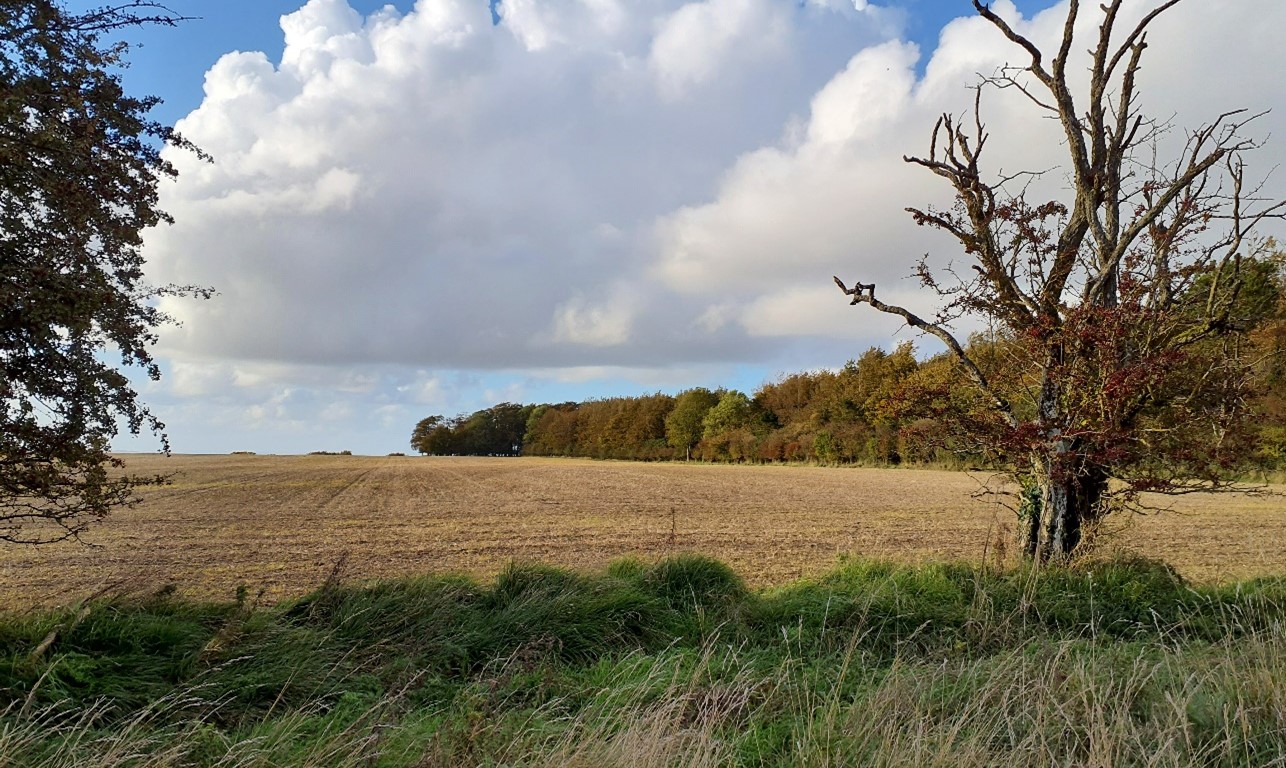
Large-scale arable fields on undulating chalk downland at Westcot Down:

×![]()
Large-scale arable fields on undulating chalk downland at Westcot Down:
Large rectilinear arable fields with woodland shelterbelt on the plateau south of Ashbury:
×![]()
Large rectilinear arable fields with woodland shelterbelt on the plateau south of Ashbury:
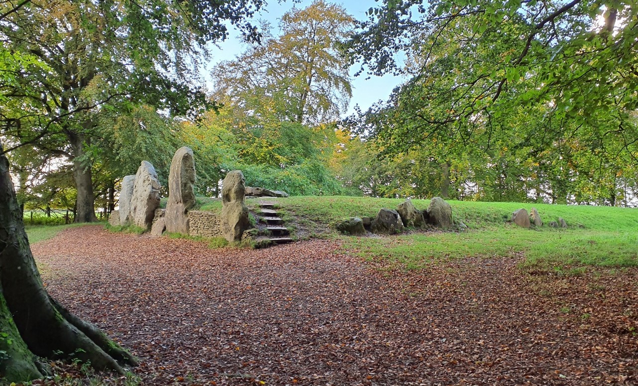
Waylands Smithy Neolithic Long Barrow:
×![]()
Waylands Smithy Neolithic Long Barrow:
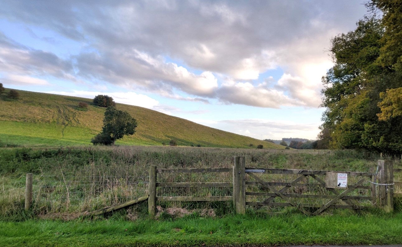
Lowland meadows and calcareous grassland on the valley slopes near Ashdown Park:
×![]()
Lowland meadows and calcareous grassland on the valley slopes near Ashdown Park:
Description
Natural (landform, water, semi-natural land cover)
- The area is underlain by the Holywell Nodular Chalk Formation, Lewes Nodular Chalk Formation and New Pit Chalk Formation. This creates an elevated rolling landform, with topography becoming more complex to the south, rising relatively steeply up to approximately 215 metres Above Ordnance Datum (AOD) at Idstone Down.
- Fingers of ridge spurs descending broadly south from the top of the steep scarp to the north. High points to the north, including Cuckhamsley Hill, reach a height of approximately 205 metres AOD.
- Woodland cover is varied and includes Ancient Woodland (as at Swinley Copse, Moss Hill and Nut Wood), more recent mixed plantations, copses on hilltops, and occasional woodland ‘hangers’ along steep slopes.
- Broad linear shelterbelts give the impression of further woodland cover. Mature tree species frequently include beech, as well as oak and ash.
- Semi-natural land cover is predominantly rough grassland, with areas of surviving chalk grassland and lowland calcareous grassland, including around Woolstone Down, Kingstone Down, Lang Down, and Knollend Down.
- The majority of wooded parkland associated with Ashdown House (including Hailey Wood, Middle Wood, Upper Wood) is recognised as semi-natural and Ancient Woodland. Avenues of lime trees and occasional small roundels reinforce the parkland character.
- Part of Middle Wood contains the Ashdown Park Site of Special Scientific Interest (SSSI), designated for the lichen flora associated with a large number of naturally situated sarsen stones.
Cultural/social (land use, settlement, infrastructure, historic character)
- Land use mainly consists of large-scale, rectilinear, open arable fields.
- Field boundaries are frequently delineated by post and wire fences and occasional scrub, with a limited hedgerow structure.
- Rides and gallops associated with horse racing are frequent features, with fields subdivided into paddocks and associated stabling.
- There is extensive evidence of prehistoric settlement and land use, including St Alfred’s Castle and Letcombe Castle Iron Age Hillforts, as well as scattered burial mounds. Later settlement is indicated by the presence of Romano-British field systems at Mere End Down. All are Scheduled Monuments.
- The Scutchamer Knob mound, believed to be an Iron Age inhumation site (now a Scheduled Monument) forms a local landmark, located on Cuckhamsley Hill and surrounded by trees.
- Ashdown Park, a Grade II* Registered Park and Gardens (RPG), is a wooded parkland, which locally influences the landscape character. It provides a setting to Ashdown House (Grade I Listed Building).
- Fieldscapes are predominantly modern, formed from amalgamation of fields into larger tracts of land.
- Sparsely populated, with settlement limited to isolated farmsteads. Road access is limited, with a small number of roads orientated broadly north-south including the A338 and B4001.
- A network of public rights of way provides recreational access across the Downs, including parts of the Ridgeway National Trail, an important historic route across the Downs. Occasional car parks are located along roadsides, providing access to the Ridgeway. A significant number of bridleways which connect with the wider network of public rights of way across the Downs.
Perceptual (views, tranquillity, associations)
- Extensive panoramic long-distance views are possible across the landscape, including rural views from the Ridgeway north across the vale landscapes towards the Corallian limestone ridge, and south across the wider North Wessex Downs.
- Provides a rural backdrop above the ridge scarp in views from within the study area to the north, including from the Corallian Limestone Ridge.
- From the top of Idstone Down, there are views across the extensive downland to the west. Woodland in Ashdown Park restricts views further east.
- Large woodland blocks frame, or form a backdrop to, views across the large-scale fields, in contrast to the more expansive views available from public rights of way across more open areas of the Downs.
- Many of the Downs are named, such as West Ginge Down, East Ginge Down, East Hendred Down, Kilman Knoll Down and Knollend Down and contribute to the sense of place.
- An open and exposed landscape with a sense of remoteness and tranquillity. Dark night skies are experienced across much of the area. The Tranquillity Assessment for South Oxfordshire and Vale of White Horse categorises 96% of the LCA in Zone 1 (‘areas of high tranquillity’).
- Generally a rural character, with few urban influences. Low-key human influences, including the B4000, gallops and horse training establishments, and Ashdown estate, locally reduce the sense of remoteness. Sparsholt Firs mast is a detracting feature on the otherwise open skyline.
Valued qualities
- Located entirely within the North Wessex Downs National Landscape, and displays many of the special qualities including remote chalk landform, ancient broadleaved woodlands, significant chalk grasslands, prehistoric monuments, country houses and landscape gardens, extensive public rights of way and high levels of tranquillity.
- Distinctive large-scale, open and elevated landscape of complex undulating topography underlain by chalk.
- Prominent woodlands, including Ancient Woodland, provide some sense of enclosure within an otherwise open landscape. Distinctive linear shelterbelts, notably in the west, do the same, although as strong linear features these can sometimes appear incongruous in the landscape.
- Semi-natural habitats, including rare chalk grasslands and deciduous woodland, provide ecological value and contribute positively to the landscape.
- Ashdown Park (RPG and SSSI), with its Ancient Woodlands, avenues of Lime trees and occasional small roundels, provides a strong parkland character and ecological value.
- Time depth provided by several heritage assets including prehistoric hillforts and burial mounds, Ashdown Park RPG, and Ashdown House (Grade I Listed Building).
- High recreational value provided by an extensive network of public rights of way, including the Ridgeway National Trail, as well as areas of Open Access Land.
- Long views southward into North Wessex Downs in Berkshire; and extensive panoramic long-distance views north across the vale landscapes towards the Corallian Limestone ridge from the Ridgeway in the north are memorable and important views.
- Strong sense of tranquillity and remoteness with dark night skies, owing to an absence of major settlement or infrastructure.
Forces for change
- Loss of woodland, hedgerows and hedgerow trees due to intensification of farming, and the poor management of those remaining. This is affecting the distinctive quality and value of prominent woodland cover.
- Loss of areas of chalk grassland due to conversion to ploughing or scrub invasion. This is affecting this distinctive and ecologically important habitat that forms one of the special qualities of the North Wessex Downs National Landscape.
- Increase in horse training facilities and associated infrastructure including gallops, fencing and stabling, which can have a suburbanising influence.
- Development within the vale affecting characteristic and distinctive panoramic views north across the vale landscapes, as well as the strong sense of tranquillity and remoteness.
- The Open Chalk Dipslope landscapes are susceptible to the impacts of climate change, including:
- Changing temperatures and extreme weather events are creating vulnerabilities in chalk grassland landscapes, leading to increased soil erosion and run-off.
- Drier summers and wetter winters could cause changes in plant and animal species and community composition of chalk grassland (for example loss of perennials, expansion of drought-tolerant ephemerals and dominance of grasses in the sward of chalk grassland).
- Drier summers leading to an increased fire risk affecting grassland habitats.
- Deciduous woodlands are facing decline due to warmer winters, altered rainfall patterns, drier summers and increased frequency of extreme events; there may be a shift in vegetation type and composition, increased competition from invasive species, greater numbers of insect and mammal pests, a greater risk of infection by various soil and water-borne pathogens, and a greater risk of wind-throw and loss of mature trees.
- Higher average temperatures and drier summers could lead to changes to community composition in arable field margins; an increase in bare ground and an increased risk of dieback in drought prone locations; the introduction of new crops and associated changes to management could alter the area and type of field margins; and an increase in agricultural use of summer insecticides which could reduce insect numbers and pollination.
- Drier summers and wetter winters may lead to increased mortality and die-back of certain hedgerow tree species; an increased occurrence of insect pests and pathogens could lead to a potential loss or significant reduction in populations of key hedgerow tree species; and increased storm activity may lead to the loss of mature and veteran trees within hedgerows.
- Intense rainfall events and increased winter rainfall resulting in flooding, erosion and damage to buildings and structures, including heritage assets.
Landscape strategy and guidelines
Increase the quantity and biodiversity of chalk grasslands.
- Manage chalk grassland to enhance its biodiversity value and appearance; ensure best practice management through suitable grazing regimes and avoiding agrochemical and fertiliser inputs; manage recreational routes to avoid/minimise disturbance; and manage scrub vegetation appropriately to maintain the open character (a certain amount of scrub can be beneficial, especially on sites that are prone to heat stress or drought, due to its shading effect potentially providing refuge for invertebrates).
- Consider opportunities to increase the area of chalk grassland through re-creation and restoration around existing areas, and ensure that areas that might act as refugia from climate change (such as areas with north facing slopes, complex micro-topography and/or low nitrogen levels) are under optimal management.
Protect broadleaved woodlands.
- Retain and enhance characteristic woodland and explore opportunities to expand and connect this through natural regeneration or small-scale planting to strengthen landscape character and bring benefits for biodiversity. Conserve and manage the Ancient Woodland sites, including Beech hangers, but avoid the creation of incongruous linear shelterbelts.
- Encourage the appropriate management of woodland, including to reduce the impacts of pests and diseases and to increase its age structure and structural heterogeneity. Consider the promotion of natural colonisation adjacent to existing woodland, allowing locally native species to develop resilience to the pressures of climate change through natural processes.
- Seek to prevent further loss or decline in the quality of remaining boundary hedgerows and encourage their restoration/reinstatement, whilst maintaining characteristic long distance panoramic views outward; when establishing new hedges, aim to diversify the range of species and select species and provenances adapted to a wider range of climatic conditions.
Maintain the historic character of the landscape and its public accessibility.
- Maintain and enhance the valued recreational use of the landscape including rights of way and National Trails, which allow appreciation of views and landscape character. Promote responsible management of existing public rights of way, including The Ridgeway National Trail, with appropriate surfacing, materials and signage to retain the rural, unsettled character of the landscape.
- Protect heritage features that contribute to the sense of time-depth in the landscape, and their open settings, including prehistoric hillforts and burial mounds, and Ashdown Park RPG.
Maintain the open rural character of the landscape with its strong sense of tranquillity and remoteness and experience of dark night skies.
- Avoid any adverse impact from new development on local character and on views from adjacent landscapes for which the area forms a setting. Large-scale agricultural structures and development associated with the horse racing industry, as well as buildings and structures associated with less rural land uses, can have an adverse impact on traditional, rural character. Use careful design, in terms of siting, scale, style, layout and materials to stay in keeping with existing dispersed, rural settlement character.
- Light pollution should be avoided in this landscape and existing light pollution reduced. Consider the impact of lighting, both external and internal, on night-time views (refer to the guidance in the Dark Skies / Light Impact Assessment for South Oxfordshire and Vale of White Horse).
- Enforce sensitive management and screening of existing equine-related features and activities. Encourage appropriate siting and management of horse training features such as gallops and avoid development of additional permanent horse exercise areas and siting of structures and exercise equipment where this is visually intrusive on the landscape.