LCT 1: Open Chalk Escarpment and Upper Slopes
Landscape character type summary
The Chalk Escarpment is the steep face and crest of the chalk downland which extends across the southern part of the Vale of White Horse district. It forms a dramatic backdrop to the chalk footslopes and lower-lying landscape of the clay vale to the north. At its eastern end the escarpments transitions into a series of steep-sided dry valleys which drop down towards the River Thames.
Two Landscape Character Areas (LCA) are identified:
- LCA 1A: Wessex Downs Open Chalk Escarpment and Upper Slopes
- LCA 1B: Aston Upthorpe Downs Open Chalk Escarpment and Upper Slopes.
LCA 1A: Wessex Downs Open Chalk Escarpment and Upper Slopes
It should be noted that the lines used to denote where LCAs border settlements are approximate and should not be used for planning purposes.
Character Area Location
A narrow, north-facing scarp slope extending across the south of the Vale of White Horse district. The area is defined by the steep topography which transitions to gentler foothill slopes to the north, and by a transition to the scarp top with rolling elevated downland to the south. The LCA is entirely within the North Wessex Downs National Landscape.
Key characteristics
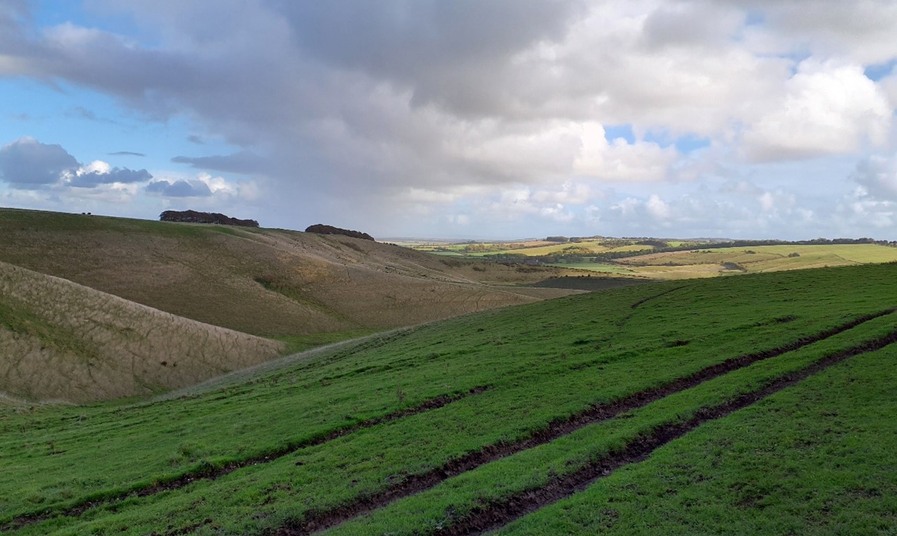
- A narrow, north-facing chalk scarp slope, with complex landform of steep local ridges and spurs forming distinctive dry coombes. Includes the distinctive Dragon Hill and the Manger on the slopes of Whitehorse Hill, and the Devil’s Punchbowl valley near Letcombe Bassett.
- Dry coombes mark the start of spring-fed watercourses which flow north down the footslopes.
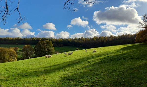
- Remnant chalk grassland and scattered woodland and occasional woodland ‘hangers,’ some identified as Ancient Woodland. Contrast between the rolling large-scale arable fields on the lower slopes and the steeper slopes used as grazed pasture.
- Very limited settlement, concentrated in the outskirts of Ashbury and Letcombe Bassett, which both have designated Conservation Areas.
- Several narrow rural lanes and public rights of way running north-south, perpendicular to the scarp. These are often sunken and enclosed by hedgebanks. Recreational access also provided by the Ridgeway National Trail in the south and at areas of Open Access Land at White Horse Hill and south-west of Letcombe Bassett.
- The landscape is rich in prehistoric remains, including several Iron Age hillforts and Uffington White Horse which is a prominent feature on the scarp.
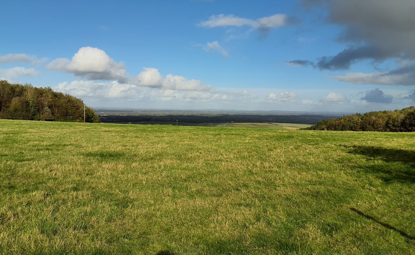
- Open landscape with panoramic views from the top of the ridge over the Vale to the north and towards the Corallian Limestone Ridge, and open views across downland to the south. The scarp itself also forms a distinctive backdrop in views south from the lower lying Vale to the north.
- A highly rural and tranquil landscape, with only the north-south running A338 in the centre and A34 in the east as locally detracting features. Good experience of dark night skies.
Remnant Chalk grasslands on Whitehorse Hill:
×![]()
Remnant Chalk grasslands on Whitehorse Hill:
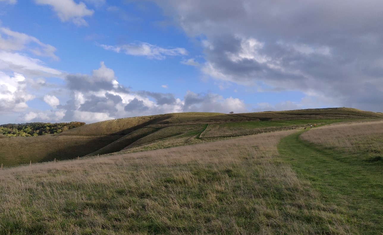
Ridge and spur landform at Crowhole Bottom:
×![]()
Ridge and spur landform at Crowhole Bottom:
Large-scale arable fields on the escarpment slopes south of Kingston Lisle:

×![]()
Large-scale arable fields on the escarpment slopes south of Kingston Lisle:
View north from Blowingstone Hill, at the top of scarp:
×![]()
View north from Blowingstone Hill, at the top of scarp:
Description
Natural (landform, water, semi-natural land cover)
- Chalk formations underlie the scarp slope, including the Holywell Nodular Chalk, Zig Zag Chalk, New Pit, Lewes Nodular and West Melbury Marly Chalk Formations.
- The scarp has a generally north-facing slope, with its crest at over 200 metres Above Ordnance Datum (AOD) and reaching 261 metres AOD on Whitehorse Hill. It features several minor valleys, including that of Letcombe Brook and several dry coombes which mark the start of spring fed watercourses flowing north down the footslopes. The topography of the escarpment varies along its length and includes steep slopes and complex twisting landforms such as Dragon Hill and The Manger on the north face of Whitehorse Hill near Woolstone, and the Devil’s Punchbowl near Letcombe Bassett.
- There are considerable areas of unimproved chalk grassland. The deep chalk coombe of The Manger at Whitehorse Hill is a Site of Special Scientific Interest (SSSI), and tracts of unimproved chalk grassland at Hackpen Warren and Gramp’s Hill near Letcombe Bassett are designated as Special Areas of Conservation (SAC) and SSSI.
- Scattered blocks of woodland occupy the slopes, including areas identified as Ancient Woodland such as Hardwell Wood. Small tree groups are frequent, and occasional linear lengths of woodland appear as ‘hangers’ along the slopes, including the semi-natural ash and hazel Uffington Wood.
Cultural/social (land use, settlement, infrastructure, historic character)
- The scarp slopes consist of grazed pasture, rough grass and scrub, along with large arable fields on the gentler slopes.
- Field boundaries have generally been lost. Where hedgerows are intact they are species-poor, dominated by hawthorn. mature elm and ash hedgerow trees are common in the west, including along tracks.
- Settlement is limited to occasional farmsteads, with settlements in the north, at the base of the scarp. Many of the farmsteads are historic, with Grade II listed buildings at Britchcombe Farm, to the south of Kingston Lisle, and at Furzewick Farm near Wantage. Letcombe Bassett retains its nucleated historic settlement pattern, and retains its Medieval core, which abuts directly onto the surrounding countryside in several locations. Ashbury, Idstone and Letcombe Bassett Conservation Areas extend into this landscape.
- The A34 dual carriageway, A338, B4002 and several rural lanes cut north-south across the scarp. Lanes which transverse up the slope link the elevated downland with settlements below the scarp. Lanes are often narrow and sunken, some enclosed by hedgebanks and overhanging trees. Other lanes cross exposed landform and are more open with lower roadside vegetation.
- Prehistoric and historic features along the scarp are distinctive and sometimes imposing features in views. These include the famous prehistoric Uffington White Horse chalk figure, Iron Age Uffington Castle, Handwell Hillfort, sections of Grim’s Ditch and a number of barrow features. These are all designated as Scheduled Monuments.
- The historic landscape comprising Uffington Castle, the White Horse, Dragon Hill and The Manger is managed by the National Trust as a visitor attraction.
- Sections of the scarp, including to the south of Uffington, have been subject to less field amalgamation than elsewhere, such as on the elevated downland to the south, with the fieldscape recorded as dating from the post medieval and pre-18th century periods. The east of the area has a mostly modern fieldscape, formed from amalgamation of fields into larger tracts of land.
- Public rights of way including footpaths and bridleways travel up the slope and connect with The Ridgeway National Trail which runs east-west along the ridge top above the scarp. There are significant areas of Open Access Land, including to the south-west of Letcombe Bassett, and at White Horse Hill.
Perceptual (views, tranquillity, associations)
- From vantage points on the scarp, including along footpaths and lanes, there are open views north over the footslopes and Vale, towards the Corallian Limestone Ridge on the horizon. There are often panoramic views towards more elevated downland beyond the district boundary to the south.
- The scarp itself forms a distinctive backdrop in views south from the lower lying Vale, and forms an immediate setting to a number of small villages located below the foot of the scarp.
- A rural landscape with minimal human influence and a good experience of dark night skies, although the sense of tranquillity is sometimes disrupted by traffic on main roads as well as frequent aircraft passing overhead. The Tranquillity Assessment for South Oxfordshire and Vale of White Horse categorises 45% of the landscape in Zone 1 (‘areas of high tranquillity’) and 54% in Zone 2 (‘areas of some tranquillity’), whilst the Dark Skies Assessment for South Oxfordshire and Vale of White Horse categorises around 90% of the area within its two darkest assessment bands.
- The large-scale landscape is often open and exposed, resulting is a sense of remoteness, although this is locally tempered by views of settlements and commercial development on the footslopes and in the vale to the north, in particular the Harwell Campus and Wantage.
Valued qualities
- Located entirely within the North Wessex Downs National Landscape and displays many of the special qualities including remote chalk landform, scattered historic farmsteads and settlements, arable habitats, significant chalk grasslands, prehistoric monuments, extensive public rights of way and areas of Open Access Land.
- Complex sloping topography, with local ridges and spurs forming distinctive dry combes and other depressions.
- Remnant chalk grassland, including at Hackpen and Gramp’s Hill SAC and at White Horse Hill SSSI, which provide ecological value and contribute positively to the landscape.
- Scattered woodland and occasional woodland ‘hangers’, including Ancient Woodland, provide notable features in the otherwise open landscape.
- Important prehistoric monuments and features contribute significant time-depth, including the Uffington White Horse, hill forts, ditches and barrows. The landscape provides an open setting to these features.
- Recreational value in the sections of The Ridgeway National Trail above the scarp, and Open Access Land, including at White Horse Hill.
- Very limited human habitation or settlement, which creates a keen sense of remoteness and tranquillity.
- Panoramic open views from the top of the ridge over the Vale and towards the Corallian Limestone Ridge provide a distinctive sense of place.
- Forms a prominent north-facing backdrop in views from the surrounding landscape and an immediate setting to a number of small villages located along the spring line at the foot of the scarp.
Forces for change
- Loss of remnant chalk grassland, affecting this distinctive and ecologically important habitats that forms one of the special qualities of the North Wessex Downs National Landscape.
- Loss of woodland, hedgerows and mature hedgerow trees due to intensification of farming, plus poor management of remaining hedgerows. This is affecting the distinctive quality and value of woodland cover within the otherwise open landscape.
- Development on the escarpment footslopes and within the vale to the north, affecting views from the Scarp and its wider setting.
- Recent and proposed development at Harwell Campus, affecting sense of remoteness and tranquillity to the east.
- The Chalk Escarpment landscapes are susceptible to the impacts of climate change, including:
- Changing temperatures and extreme weather events are creating vulnerabilities in chalk grassland landscapes, leading to increased soil erosion and run-off.
- Drier summers and wetter winters could cause changes in plant and animal species and community composition of chalk grassland (for example loss of perennials, expansion of drought-tolerant ephemerals and dominance of grasses in the sward of chalk grassland).
- Drier summers leading to an increased fire risk affecting grassland habitats.
- Deciduous woodlands are facing decline due to warmer winters, altered rainfall patterns, drier summers and increased frequency of extreme events; there may be a shift in vegetation type and composition, increased competition from invasive species, greater numbers of insect and mammal pests, a greater risk of infection by various soil and water-borne pathogens, and a greater risk of wind-throw and loss of mature trees.
- Higher average temperatures and drier summers could lead to changes to community composition in arable field margins; an increase in bare ground and an increased risk of dieback in drought prone locations; the introduction of new crops and associated changes to management could alter the area and type of field margins; and an increase in agricultural use of summer insecticides which could reduce insect numbers and pollination.
- Drier summers and wetter winters may lead to increased mortality and die-back of certain hedgerow tree species; an increased occurrence of insect pests and pathogens could lead to a potential loss or significant reduction in populations of key hedgerow tree species; and increased storm activity may lead to the loss of mature and veteran trees within hedgerows.
- Intense rainfall events and increased winter rainfall resulting in flooding, erosion and damage to buildings and structures, including heritage assets.
Landscape strategy and guidelines
Increase the quantity and biodiversity of chalk grasslands.
- Manage chalk grassland to enhance its biodiversity value and appearance; ensure best practice management through suitable grazing regimes and avoiding agrochemical and fertiliser inputs; manage recreational routes to avoid/minimise disturbance; and manage scrub vegetation appropriately to maintain the open character (a certain amount of scrub can be beneficial, especially on sites that are prone to heat stress or drought, due to its shading effect potentially providing refuge for invertebrates).
- Consider opportunities to increase the area of chalk grassland through re-creation and restoration around existing areas, and ensure that areas that might act as refugia from climate change (such as areas with north facing slopes, complex micro-topography and/or low nitrogen levels) are under optimal management.
Improve the biodiversity of arable farmland.
- Manage arable land to enhance its biodiversity value and connectivity, by maintaining and expanding the area of land available for uncultivated arable field margins; seek to maximise the diversity of margins to provide a range of habitats and to assist in the movement of species through the landscape and include species and cultivars that are able to tolerate and flower under hotter, drier summers.
- Seek to prevent further loss or decline in the quality of remaining boundary hedgerows and encourage their restoration/reinstatement, whilst maintaining characteristic long-distance views north; when establishing new hedges, aim to diversify the range of species and select species and provenances adapted to a wider range of climatic conditions.
Maintain the historic character of the landscape and its public accessibility.
- Maintain the valued recreational use of the landscape which allows appreciation of views and landscape character.
- Protect heritage features that contribute to the sense of time-depth in the landscape, and their open settings, including the Uffington White Horse, hill forts and barrows.
Maintain and enhance the pattern of scattered woodland and woodland ‘hangers’ which form notable features in the otherwise open landscape.
- Retain and enhance scattered woodland and explore opportunities to expand and connect existing woodland and tree cover through natural regeneration or small-scale planting to strengthen landscape character and bring benefits for biodiversity; conserve and manage the Ancient Woodland sites, including ‘hangers’.
- Encourage the appropriate management of woodland, including to reduce the impacts of pests and diseases and to increase its age structure and structural heterogeneity. Consider the promotion of natural colonisation adjacent to existing woodland, allowing locally native species to develop resilience to the pressures of climate change through natural processes.
Maintain the open rural character of the landscape which creates a keen sense of remoteness and tranquillity. Protect characteristic long views outwards and consider the role of the area as an undeveloped backdrop to views back from the vale.
- There is little scope for new development in this sensitive and very visible landscape. Avoid the adverse impact of any new buildings or structures on local character and on views from other areas. Use careful design, in terms of siting, scale, style, layout and materials to stay in keeping with existing settlement character and to preserve the openness of areas/features which are important to the landscape setting of settlements.
- Light pollution should be avoided or reduced in this landscape, with new lighting only introduced where necessary. Consider the impact of lighting, both external and internal, on night-time views from lower ground as well as within the locality. Refer to the guidance in the Dark Skies / Light Impact Assessment for South Oxfordshire and Vale of White Horse
- Protect and where possible enhance panoramic open views north from the top of the ridge over the Vale and towards the Corallian Limestone Ridge.
LCA 1B: Aston Upthorpe Downs Open Chalk Escarpment and Upper Slopes
It should be noted that the lines used to denote where LCAs border settlements are approximate and should not be used for planning purposes.
Character Area Location
Open chalk downland and scarp that sits between the A34 to the west and the Thames valley to the east. The LCA lies within the south of both Vale of White Horse and South Oxfordshire districts, and the landscape continues to the south into West Berkshire. The LCA is entirely within the North Wessex Downs National Landscape.
Key characteristics
- Elevated rolling downland with round or flat-topped hills, intersected by dry valleys.
- An open landscape, featuring ecologically important unimproved chalk grassland. Grazing pasture on the steeper slopes and arable fields on the gentler slopes.
- Sparse woodland cover, except for woods on slopes in the south-east; field boundaries are also often open with occasional mature hedgerow trees.
- Largely undeveloped area, with settlement limited to occasional small farmsteads and isolated dwellings, and road access limited to a few rural lanes. Horse rides and gallops are a feature in the west.
- Prehistoric earthworks and hillforts provide a considerable time-depth.
- Public rights of way provide access to the slopes and connect to The Ridgeway National Trail to the south.
- Open, panoramic views from vantage points on the scarp north over the footslopes and vale towards Corallian Limestone Ridge, and south towards the downlands. Views are occasionally shortened by topography and tree cover.
- The scarp forms a distinctive backdrop in views from the south, and from the Vale to the north.
- A highly rural and tranquil landscape, with only the A417 in the north and A34 in the west as detracting features. Good experience of dark night skies.
Elevated rolling downland (Moulsford):

×![]()
Elevated rolling downland (Moulsford):
Grazing pasture on steeper slopes (Moulsford Downs):
×![]()
Grazing pasture on steeper slopes (Moulsford Downs):
Isolated farmstead, and rural lanes (Starveall Farm):

×![]()
Isolated farmstead, and rural lanes (Starveall Farm):
Woods in the south-east which cloak the slopes (Unhill Woods):

×![]()
Woods in the south-east which cloak the slopes (Unhill Woods):
Description
Natural (landform, water, semi-natural land cover)
- The scrap is underlain by chalk formations, including the Holywell Nodular Chalk, Zig Zag Chalk, New Pit, Lewes Nodular and West Melbury Marly Chalk Formations. The area has distinctive ‘grey’ and flinty soils.
- The topography of the scarp varies, with smoothly rounded hills and downland flanks ranging between 50 metres and 180 metres Above Ordnance Datum (AOD). Intimate dry valleys dissect the chalk downs. Slopes are generally northeast facing, with notable hills including Baldon Hill (132 metres AOD), Riddle Hill (140 metres AOD), Churn Hill (160 metres AOD), and Lowbury Hill (186 metres AOD) .
- Remnant areas of unimproved chalk grassland are designated as Sites of Special Scientific Interest (SSSI) at Aston Upthorpe Downs and Moulsford Downs, and as a Local Wildlife Site (LWS) above Lids Bottom.
- Woodlands are concentrated in the east, principally on slope sides and hill tops, such as Churn Hill. Priority Habitat ‘deciduous woodlands’ cloak the slopes and Ham Wood and Unhill Woods are recorded as Ancient Woodland.
Cultural/social (land use, settlement, infrastructure, historic character)
- There are grazed pastures on the steeper slopes and large arable fields on the gentler slopes, with some horse paddocks next to farmsteads and settlements. Horse rides and gallops and large-scale pig farming have changed the field pattern.
- Field boundaries have generally been lost, resulting in an open landscape. Where hedgerows are intact, they are species-poor, dominated by hawthorn, with occasional mature elm and ash hedgerow trees.
- Settlement is limited to occasional farmsteads and isolated dwellings. The villages of Upton and Blewbury lie to the immediate north, and the scarp landscape provides a setting.
- The majority of the fieldscape is identified as modern amalgamations of smaller fields, although an area of medieval field patterns is recorded in the centre.
- The area has considerable prehistoric earthworks and hillforts, including bell, bowl and round barrows at a Bronze Age cemetery on Churn Hill, and a possible Roman Temple on Lowbury Hill. These are all Scheduled Monuments.
- Road access is limited to a few rural lanes enclosed by hedgebanks and trees, that traverse the slopes. These connect the Downs with Blewbury and Upton. The busy A417 runs along the foot of the scarp, with the A34 in the west, cutting through the landscape.
- Public rights of way climb the slopes and connect to The Ridgeway National Trail to the south. Small areas of the downs are Open Access Land. Modern recreation activities including motocross and an indoor activities site have intensified the use of farmsteads and buildings and attract more users and cars to the area.
Perceptual (views, tranquillity, associations)
- Open panoramic views north, particularly from vantage points on the top of the scarp towards the Vale and Corallian Limestone Ridge on the horizon. There are also often panoramic views towards more elevated downland beyond the district boundary. Open views across the arable fields available in the east, owing to the limited tree cover.
- Views are occasionally shortened by topography and tree cover.
- The scarp itself forms a distinctive backdrop in views from the south and from the Vale to the north.
- A rural, peaceful landscape with limited human influence. Views of settlement within the footslopes and more distantly within the Vale to the north, and major roads the A417 and A34 reduce the sense of tranquillity and remoteness. The Tranquillity Assessment for South Oxfordshire and Vale of White Horse categorises 47% of the LCA in Zone 1 (‘areas of high tranquillity’) and 53% in Zone 2 (‘areas of some tranquillity’).
Valued qualities
- Located entirely within the North Wessex Downs National Landscape and displays several of its special qualities, including remote chalk landform, arable habitats, significant chalk grasslands, prehistoric monuments, and extensive public rights of way.
- Distinctive landform of rolling downland with round or flat-topped hills, intersected by dry valleys.
- Remnant chalk grassland, including at Aston Upthorpe Downs and Moulsford Downs SSSI, which provide ecological value and contribute positively to the landscape.
- Distinctive scattered woodland on hilltops and slopes including Ancient Woodland at Ham and Unhill Woods provide enclosure in an otherwise open landscape.
- Frequent prehistoric features, including a possible Roman temple at Lowbury Hill and Churn Hill cemetery, provide significant time-depth.
- Recreational value in public rights of way that traverse the steep scarp slopes, connecting settlements and the Vale to the Downs. The Ridgeway skirts the southern edge of the LCA and contributes to the recreational network.
- Very limited human habitation or settlement, creating a strong sense of remoteness and tranquillity.
- Panoramic views from the top of the ridge over the Vale and towards the Corallian Limestone Ridge provide a distinctive sense of place.
- Forms a distinctive backdrop in views from the south and from the Vale to the north.
Forces for change
- Agricultural intensification, diversification and farm amalgamation leading to loss and/or poor management of woodland, hedgerows and mature hedgerow trees. This is affecting the distinctive quality and value of woodland cover within the otherwise open landscape.
- Introduction of horse gallops and large-scale pig farming has changed the field pattern and introduced new structures in an otherwise open landscape.
- Increasing pressure for alterative recreation, leading to intensification of farmsteads and buildings to facilitate these, in a largely unsettled landscape.
- Loss of remnant chalk grassland affecting this distinctive and ecologically important habitats that forms one of the special qualities of the North Wessex Downs National Landscape.
- Development within the vales and on escarpment footslopes to the north, including larger-scale development at Harwell Campus, which is affecting panoramic views from the escarpment and its wider setting, as well as the sense of remoteness and tranquillity.
- The Chalk Escarpment landscapes may be susceptible to the impacts of climate change, including:
- Changing temperatures and extreme weather events are creating vulnerabilities in chalk grassland landscapes, leading to increased soil erosion and run-off.
- Drier summers and wetter winters could cause changes in plant and animal species and community composition of chalk grassland (for example loss of perennials, expansion of drought-tolerant ephemerals and dominance of grasses in the sward of chalk grassland).
- Drier summers leading to an increased fire risk affecting grassland habitats.
- Deciduous woodlands are facing decline due to warmer winters, altered rainfall patterns, drier summers and increased frequency of extreme events; there may be a shift in vegetation type and composition, increased competition from invasive species, greater numbers of insect and mammal pests, a greater risk of infection by various soil and water-borne pathogens, and a greater risk of wind-throw and loss of mature trees.
- Higher average temperatures and drier summers could lead to changes to community composition in arable field margins; an increase in bare ground and an increased risk of dieback in drought prone locations; the introduction of new crops and associated changes to management could alter the area and type of field margins; and an increase in agricultural use of summer insecticides which could reduce insect numbers and pollination.
- Drier summers and wetter winters may lead to increased mortality and die-back of certain hedgerow tree species; an increased occurrence of insect pests and pathogens could lead to a potential loss or significant reduction in populations of key hedgerow tree species; and increased storm activity may lead to the loss of mature and veteran trees within hedgerows.
- Intense rainfall events and increased winter rainfall resulting in flooding, erosion and damage to buildings and structures, including heritage assets.
Landscape strategy and guidelines
Consider the role of this area as part of the North Wessex Downs National Landscape. Conserve and enhance the distinctive pattern of elements (including chalk landform, chalk grasslands, arable habitats, prehistoric monuments and extensive public rights of way) which contributes positively to the character and special qualities of the National Landscape.
- Manage chalk grassland to enhance its biodiversity value and appearance; ensure best practice management through suitable grazing regimes and avoiding agrochemical and fertiliser inputs; manage recreational routes to avoid/minimise disturbance; and manage scrub vegetation appropriately to maintain the open character (a certain amount of scrub can be beneficial, especially on sites that are prone to heat stress or drought, due to its shading effect potentially providing refuge for invertebrates).
- Consider opportunities to increase the area of chalk grassland through re-creation and restoration around existing areas, and ensure that areas that might act as refugia from climate change (such as areas with north facing slopes, complex micro-topography and/or low nitrogen levels) are under optimal management.
- Manage arable land to enhance its biodiversity value and connectivity, by maintaining and expanding the area of land available for uncultivated arable field margins; seek to maximise the diversity of margins to provide a range of habitats and to assist in the movement of species through the landscape and include species and cultivars that are able to tolerate and flower under hotter, drier summers.
- Maintain the valued recreational use of the landscape which allow appreciation of views and landscape character.
- Protect heritage features that contribute to the sense of time-depth in the landscape, and their open settings, including at Churn Hill and Lowbury Hill.
Maintain and enhance the distinctive pattern of scattered woodland on hilltops and slopes which form notable features in the otherwise open landscape.
- Retain and enhance scattered woodland and explore opportunities to expand and connect existing woodland and tree cover through natural regeneration or small-scale planting to strengthen landscape character and bring benefits for biodiversity; conserve and manage the Ancient Woodland sites.
- Encourage the appropriate management of woodland, including to reduce the impacts of pests and diseases and to increase its age structure and structural heterogeneity. Consider the promotion of natural colonisation adjacent to existing woodland, allowing locally native species to develop resilience to the pressures of climate change through natural processes.
- Seek to prevent further loss or decline in the quality of remaining boundary hedgerows and encourage their restoration/reinstatement, whilst maintaining characteristic long-distance views outward; when establishing new hedges, aim to diversify the range of species and select species and provenances adapted to a wider range of climatic conditions.
Maintain the open rural character of the landscape which creates a keen sense of remoteness and tranquillity. Protect characteristic long views and consider the role of the area as an undeveloped backdrop to views back from the vale.
- There is little scope for new development in this sensitive and very visible landscape. Avoid the adverse impact of any new development on local character and on views from other areas. Use careful design, in terms of siting, scale, style, layout and materials to stay in keeping with existing settlement character and to preserve the openness of areas/features which are important to the landscape setting of settlements.
- Light pollution should be avoided or reduced in this landscape, with new lighting only introduced where necessary. Consider the impact of lighting on night-time views from lower ground as well as within the locality. Refer to the guidance in the Dark Skies / Light Impact Assessment for South Oxfordshire and Vale of White Horse.
- Protect and where possible enhance panoramic open views north from the top of the ridge over the Vale and towards the Corallian Limestone Ridge.
- Consider impact of development in adjacent areas, such as the vales and escarpment footslopes, on views outwards from the National Landscape.