Candidate LLD: West of Wantage LLD
Summary information
Extent of area
This LLD is located within the Vale of White Horse district, between East Challow in the east and Idstone in the west. It comprises a narrow band of rolling, north-facing slopes which transition between the low-lying vales in the north and the higher North Wessex Downs chalk escarpment and footslopes in the south.
Landscape character context
The LLD includes parts of the following Landscape Character Areas:
- LCA 9A: Western Vale Edge Slopes
- LCA 11B: Western Upper Vale
Location of West of Wantage LLD - View map full screen
Statement of significance
An east-west band of north-facing slopes which form the transition from the chalk escarpment of the North Wessex Downs National Landscape in the south to the low-lying vale in the north. Numerous small streams incise the landscape during their passage from the source, at the foot of the scarp, to the River Ock. Frequent, scattered woodland blocks, many of which are ancient, are often associated with the regularly spaced springline small historic settlements. The landscape also forms an important setting to Uffington in the vale. Recreational access to the landscape takes the form of numerous public rights of way which provide links between the North Wessex Downs National Landscape and the vale. The landscape has a strong traditional rural character with high levels of tranquillity and few detracting features.
Summary of special landscape qualities
- The rolling topography provides a clear link between the vale landscapes to the north and chalk escarpments to the south, numerous spring-fed streams incise the slopes as they flow north towards the River Ock.
- Frequent scattered woodlands contribute to the natural heritage and provide contrast to the open downland to the south.
- Arable landscape with smaller pastoral fields close to villages contribute to the rural setting of the North Wessex Downs National Landscape.
- Parkland and estate landscapes which provide a well-managed ornamental character and a distinctive sense of place and time depth.
- Strong visual relationship with the low-lying vale to the north, over which gaps in tree cover allow panoramic views across the vale.
- Long views from open higher ground contrast with sense of enclosure near watercourses and settlements.
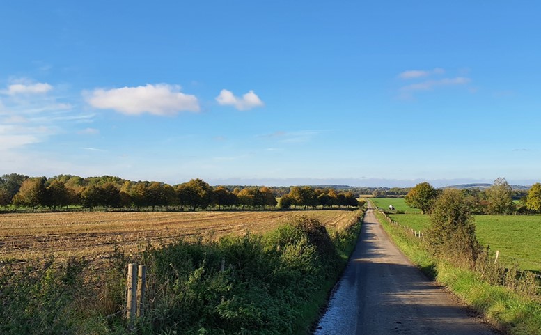
Long-distance views north across the vale from Knighton
×![]()
Long-distance views north across the vale from Knighton
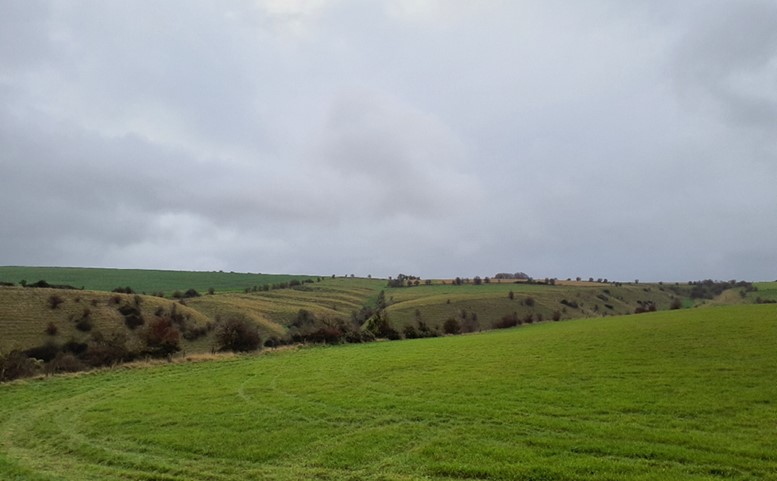
Open farmland across steep chalk slopes
×![]()
Open farmland across steep chalk slopes
Full evaluation
Local distinctiveness and sense of place
- A band of relatively steep, north-facing slopes underlain by chalk and sandstones, incised by numerous spring-fed streams flowing north towards the River Ock.
Landscape quality (condition and intactness)
- Predominantly large-scale arable fields, a mixture of pre-18th century and modern fieldscapes. Smaller-scale fields are generally located in proximity to villages. Some deterioration of hedgerows is evident in more intensively farmed areas.
- Open farmland separates villages and hamlets, helping to retain their individual identities and the characteristic regular spacing of settlements along the slopes.
- Tree groupings are often associated with areas of settlement and provide screening, landscape structure, and a sense of enclosure.
Scenic qualities and perceptual aspects
- Large, arable fields on the rolling footslopes serve as an undeveloped backdrop to views from the lower-lying vale in the north.
- More frequent woodland cover and riparian vegetation in and around settlements creates a stronger sense of enclosure and more restricted views.
- Open higher ground in the LLD allows long views north across the lower-lying vale landscapes towards the wooded limestone ridge in the distance.
- The LLD forms part of the northern, rural setting to the North Wessex Downs National Landscape.
- The area has a strong rural quality with limited settlement internally, landform and tree cover reduce the influence of the B4057 where it follows the upper slopes along the boundary of the LLD (the course of a Roman Way) and is locally detracting.
Natural and cultural qualities
- Tree cover comprises small, dispersed blocks of woodland scattered along the footslopes, including areas of ancient woodland, riparian woodland along watercourses, traditional orchard, other small tree groups and trees along field boundaries, particularly in pastoral areas and on the edges of settlement.
- Estates and parkland are associated with some of the settlements, including the Grade II Compton Beauchamp Registered Park and Garden. Sparsholt and Kingstone Lisle (contains an extant Grade II* Manor House) are undesignated parks. Moats, coverts and copses, combine to form a parkland character. Time depth is also provided by a Roman villa near East Challow and Grade I listed churches at Sparholt and Childrey.
- Settlements are generally located near the source of spring-fed streams, resultant of historic land uses. Their historic cores date back to the medieval period and are often covered by Conservation Area designations, they have seen very little modern expansion.
Recreation value
- A good network of public rights of way, including the D’Arcy Dalton Way and Vale Way, provide recreational value and north-south links between the North Wessex Downs and vale. Public rights of way also provide links between the village of Uffington in the vale and the Uffington White Horse to the south (within the North Wessex Downs National Landscape).
Associations
- The manors associated with Childrey, Kingstone Lisle, Woolstone and Compton Beauchamp have links with historic figures and royalty – Kingstone Lisle Park was imparked by Alice de Lisle, granddaughter of Henry I fitzGerold, and Compton Beauchamp House was the home of the King’s Councillor, Sir Thomas Fettiplace, from about 1507.
- Kingston Lisle features in Thomas Hughes’ novel Tom Brown’s School Days.
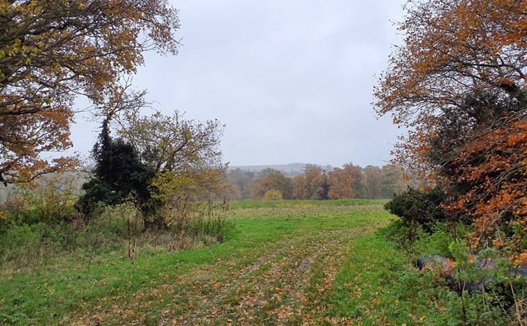
Dispersed woodland blocks across the footslopes
×![]()
Dispersed woodland blocks across the footslopes
Arable fields across the slopes backdrop the low-lying vale

×![]()
Arable fields across the slopes backdrop the low-lying vale
Landscape guidelines
Guidance to protect/conserve current landscape character
- Retain woodland blocks and tree lines; conserve and manage the ancient woodland sites to improve landscape character and encourage biodiversity.
- Protect long views north across the lower-lying vale landscapes towards the wooded Corallian Limestone Ridge in the distance.
- Maintain the open character of farmland which forms gaps between individual settlements, contributes positively to the setting of North Wessex Downs National Landscape, and forms an undeveloped backdrop to views from the vale.
- Encourage management in parklands and support plans for restoration where appropriate. Conserve and appropriately manage veteran trees within parkland areas.
- Protect historic landscape features as well as their setting and legibility in the landscape. Maintain physical and visual connectivity between Conservation Areas and prominent features in settlement setting.
Guidance to manage landscape character
- Encourage the appropriate management of woodland, including to reduce the impacts of pests and diseases and to increase its age structure and structural heterogeneity.
- Support appropriate management and restoration of parkland and historic landscapes through (for example) the planting of a new generation of specimen trees and appropriate grassland management.
Guidance to plan (enhance, restore, create) landscape character
- Encourage landowners to develop a woodland management strategy to conserve existing woodlands (including ancient woodland) and extend woodland where appropriate. Ensure any new woodland planting is respectful of local character and ecological conditions and maximises opportunities to link with other habitats.
- Prevent further loss or decline in the quality of remaining boundary hedgerows and encourage their restoration/reinstatement, whilst maintaining characteristic long-distance views north; when establishing new hedges, aim to diversify the range of species and select species and provenances adapted to a wider range of climatic conditions.
- Minimise the impact of new development, including housing and horsiculture (including arenas and associated lighting), on the widely visible vale-edge slopes. Use trees and woodland to integrate development into the landscape, including that on the edge of East Challow.
- Respect the existing small-scale, scattered settlement pattern, and use local vernacular materials (such as brick, chalk clunch, and timber framing) in keeping with the existing settlement character.