Candidate LLD: East Oxford Hills and Otmoor Floodplain LLD
Summary information
Extent of area
This area is located east of Oxford City and comprises the low wooded ridge that rises above the surrounding vale, and the related important river valley. It stretches from Woodeaton and Otmoor in the north to Garsington in the south. It encompasses Shotover Country Park and Elsfield in the west, and Cuddesdon and Stanton Great Wood in the east.
Landscape character context
The LLD includes parts of the following Landscape Character Areas:
- LCA 7C: Oxford East Ridge Hilltops
- LCA 12D: Oxford Middle Vale
- LCA 12F: Studley Middle Vale
- LCA 12G: Cherwell Middle Vale
Location of East Oxford Hills and Otmoor floodplain LLD - View map full screen
Statement of significance
A low belt of limestone and sandstone hills that surround Oxford and rise prominently above Cherwell Valley and Otmoor lowlands in the north, and the River Thame floodplain in the east and south. An agricultural landscape combining arable and pasture in rectilinear patterns. Agricultural land uses together with the sparse settlement pattern create a strong rural character. Large blocks of deciduous woodland are scattered across the landscape, combining with the many small valleys to create a strong sense of enclosure and high levels of tranquillity. Buildings reflect the underlying geology and settlements are connected by a network of small sunken lanes with low trimmed hedges. High recreational value is in the form of a lattice of public rights of way including the Oxfordshire Way promoted path and large areas of publicly accessible woodland such as Shotover Hill.
Summary of special landscape qualities
- Distinctive low limestone and sandstone ridge, with an undulating landform of valleys and hills.
- Woodland features widely throughout, creating a wooded backdrop from the surrounding vales and urban areas. Many areas of woodland are ancient.
- High biodiversity value in the form of a variety of semi-natural habitats including grassland, woodland and fen, many of which are SSSIs.
- A sparsely settled and diverse, patchwork landscape comprising arable farmland, semi-natural habitats and parklands.
- High visual interest with woodland and landform combining to create enclosure, in contrast with the more exposed, open character on ridges and higher ground, and the open floodplain of Otmoor.
- Historic parkland, medieval moated sites at Holton House and Church Farm, as well as historic villages provide time depth and a strong sense of place.
Footpath through Sydlings Copse

×![]()
Footpath through Sydlings Copse
Long-distance view north from Shotover Country Park

×![]()
Long-distance view north from Shotover Country Park
Full evaluation
Local distinctiveness and sense of place
- Distinctive undulating landform of hills, ridges and valleys, which contrasts with the surrounding lower-lying vale and floodplain landscapes to the north, east and south.
- Local highpoints include Shotover Hill (170 metres AOD), Thorn Hill (154 metres AOD), Beckley Hill (141 metres AOD) and Red Hill (134 metres AOD), which are distinctive skyline features.
- Sparsely settled with buildings in the villages reflecting underlying geology – many older houses constructed from the distinctive local Corallian Limestone. Red tiles or thatch are common as roofing materials.
- The open landscape provides an immediate setting to settlements, helping to retain their individual and historic character.
- Large and frequent areas of woodland across the hills form a special character and confer a recognisable sense of place.
Landscape quality (condition and intactness)
- The varied topography, mixed land use and strong woodland and tree cover create an attractive, diverse, patchwork landscape.
- Historic clustered settlement has been preserved in villages which are connected by a network of small rural lands, many of which are covered by Conservation Area designations, such as Woodeaton and Elsfield.
- The landscape is drained by a network of watercourses forming tributaries of the Cherwell, Thame, or the Thames to the south-west, creating numerous shallow valleys.
- There is a naturalistic wetland landscape near Otmoor which is part of the functioning floodplain of the River Ray (which extends into Cherwell district to the north).
- Predominantly large-scale arable in rectilinear field pattern, often with a weak hedgerow structure in areas that are intensively farmed. Pasture features more widely in the north and combines with smaller-scale fields across the steeper slopes.
Scenic qualities and perceptual aspects
- Contrast between a sense of enclosure formed by the rising landform and woodland, and the exposed character on the more open ridges and areas of high ground where arable farming dominates. Longer views from high points such as Shotover Hill and Beckley Hill allow spectacular views to Oxfordshire and Otmoor respectively.
- Skies are typically darker than in much of the district, contributing to the sense of night-time tranquillity. However, arterial transport corridors and proximity to larger urban areas such as Wheatley and Oxford are locally detracting. Large-scale arable areas which feature electricity pylons reduce the sense of remoteness in the farmland landscape.
- Forms a wooded, green backdrop in views from the lower lying vale and floodplain landscapes in the north, east and south, including the eastern setting of Oxford.
Natural and cultural qualities
- Areas of deciduous woodland (some of which are ancient), and other rare, semi-natural habitats provide ecological value, and contribute positively to the landscape. The landscape has a number of SSSIs associated with woodland (Stanton Great Wood), calcareous fen, acid and limestone grassland (Brasenose Wood and Shotover Hill), and former extraction sites (Woodeaton Quarry).
- Historic settlements, many of which are covered by Conservation Area designations, and provide a strong sense of time depth, contain clusters of listed buildings including several Grade I listed churches (Church of St John the Baptist, Church of the Assumption of the Blessed Virgin Mary, Church of the Holy Rood).
- Historically significant sites which provide historic landscape character include medieval moated sites at Holton House and Church Farm (Scheduled Monuments), as well as Shotover House with its 18th century formal parkland, and Beckley Park (both Registered Parks and Gardens). Undesignated historic sites include the medieval village of Woodperry and a palace at Beckley.
- The LLD encompasses part of the Otmoor SSSI which comprises a number of priority habitats including purple moor grass and rush pastures, lowland meadows, lowland fens, and coastal and floodplain grazing marsh. These features provide ecological value and contribute positively to the landscape.
Recreation value
- A good level of access to the landscape is provided by a number of public rights of way including the Oxford Greenbelt Way and the Oxfordshire Way promoted paths.
- Shotover Country Park contains locally significant blocks of priority habitat deciduous woodland, and provides important recreational opportunities over 117 acres of publicly accessible land.
- Otmoor RSPB Nature Reserve is one of the largest inland wetland complexes in the country. A small part of the reserve falls within the LLD (the rest is in Cherwell district), and is accessible by public rights of way. It is a haven for birdlife, and a popular destination for birdwatchers with views across the wider reserve to the north.
Associations
- Shotover House was built for James Tyrrell of Oakley, parts of the property were designed by William Townesend and William Kent. The painter John Everett Millais painted Ferdinand Lured by Ariel during his stay at Shotover. During WWII there was a prisoner-of-war camp in the grounds.
- The manor at Beckley has a long history of royal ownership including King Richard II who gave it to Anne of Bohemia as part of her dowry.
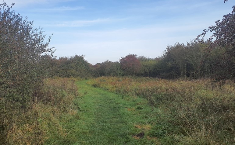
Footpath through low-lying floodplain near Otmoor
×![]()
Footpath through low-lying floodplain near Otmoor
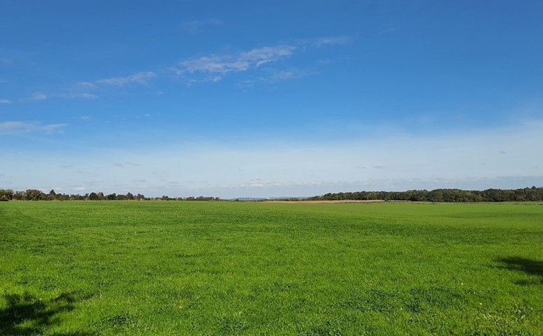
Long views towards Oxford across open areas of high ground
×![]()
Long views towards Oxford across open areas of high ground
Landscape guidelines
Guidance to protect/conserve current landscape character
- Retain and enhance woodland cover across the hills, particularly where it makes a strong scenic and ecological contribution.
- Protect the experiential qualities of the landscape, particularly the high levels of tranquillity and intact rural character.
- Encourage management in parklands and support plans for restoration where appropriate. Conserve and appropriately manage veteran trees within parkland areas.
- Conserve the wetland habitat, including by protection against harmful effects of livestock grazing and drainage for agricultural use.
- Seek to prevent further loss or poor management of hedgerows and hedgerow trees and encourage their restoration/reinstatement, while maintaining characteristic longer-range views outward.
- Avoid urban development or other forms of non-agricultural development within more open areas.
- Protect historic features in the landscape to ensure their legibility (contribution to a sense of time-depth) and historic integrity including those that are non-designated.
Guidance to manage landscape character
- Support appropriate management and restoration of parkland and historic landscapes through (for example) the planting of a new generation of specimen trees and extensive grassland management.
- Encourage the appropriate management of woodland, including to reduce the impacts of pests and diseases and to increase its age structure and structural heterogeneity. Consider the promotion of natural colonisation adjacent to existing woodland, allowing locally native species to develop resilience to the pressures of climate change through natural processes.
- Encourage appropriate management of the floodplain landscape to enhance its contribution to landscape character and its nature conservation value.
- Maintain the valued recreational use of the landscape which allow appreciation of views and landscape character.
Guidance to plan (enhance, restore, create) landscape character
- Explore opportunities to expand and connect existing woodland and tree cover through natural regeneration or small-scale planting, particularly around settlements, whilst maintaining characteristic longer-range views from hillsides and higher ground across the surrounding lower-lying vales.
- Restore historic field boundaries which have been lost to agricultural intensification to improve the legibility of historic field patterns and strengthen landscape character and structure, and enhance ecological corridors.
- Minimise the impact of any new development on the widely visible vale-edge slopes. Respect the existing small-scale, scattered settlement pattern, and use materials in keeping with the existing settlement character such as stone, red brick, red clay tiles, and slate or thatch roofs. Use trees and woodland to integrate development into the landscape, particularly any development close to the edges of Oxford and Wheatley.
- Consider the impact of any new development on views from Oxford City.
- Seek opportunities to enhance connectivity between the floodplain wetland habitats and other nearby habitats to create green corridors and networks.