LCT 7: Ridge Hilltops
Contextual map of LCT 7 - View map full screen
Component Landscape Character Areas
- LCA 7A: Faringdon Ridge Hilltops
- LCA 7B: Oxford West Ridge Hilltops
- LCA 7C: Oxford East Ridge Hilltops
- LCA 7D: Oxford South Ridge Hilltops
LCA 7A: Views to Westmill Wind Farm north of Watchfield
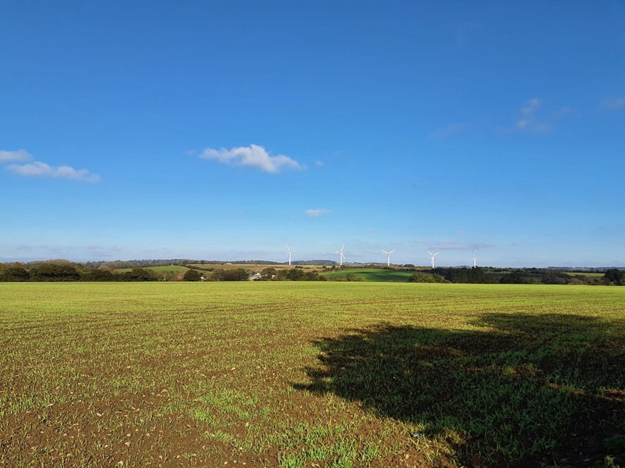
×![]()
LCA 7A: Views to Westmill Wind Farm north of Watchfield
LCA 7B: Views across slopes to Oxford city

×![]()
LCA 7B: Views across slopes to Oxford city
Assessment of landscape sensitivity to renewable energy development
Landscape sensitivity assessment
Landform and scale (including sense of openness/ enclosure)
- Gently undulating limestone and sandstone hills, ranging between approximately 60 metres AOD and 170 metres AOD. The hills surround the city of Oxford and the town of Faringdon in the west of the Vale of White Horse District.
- Slopes of varying steepness transition the landscape to neighbouring vales or river floodplains. Some steeper slopes are located around watercourses and localised high points, notably Shotover Hill (170 metres AOD), Bradbury Hill (160 metres AOD) and Thorn Hill (154 metres AOD).
- Several small spring-fed streams, such as Pennyhooks Brook, and Bayswater Brook incise the landscape as they flow to larger watercourses such as the River Cole and River Thame.
- Sense of enclosure is largely dependent on the dispersal of woodland across the landscape, some areas which contain significant blocks of woodland, including riparian and coniferous woodland (e.g. between Kennington and Wootton, along the River Cole, and near Wytham Great Wood), are more enclosed. Areas where woodland is sparse, such as east of Barton and near Garsington are more open.
- Field patterns and hedgerows also vary and affect enclosure – some areas of smaller-scale fields surrounded by species-rich hedgerows featuring mature trees such as oaks and sycamore provide a stronger sense of enclosure (such as around Boars Hill and east of Beckley) than larger arable areas lacking significant boundary vegetation (such as north of Watchfield and near Garsington).
- Human scale features include low-density settlements comprising scattered farmsteads and small villages such as Nuneham Courteney and Marsh Baldon.
Landcover (including field and settlement patterns)
- A mixture of large-scale and medium-scale arable and pastoral farmland generally defined by intact hawthorn hedges, with areas of estate land (such as Buscot Park, Coleshill Park and Nuneham Park), and smaller scale parcels of land associated with settlement (Foxcombe Hill and Boars Hill). Smaller areas of pasture often feature close to settlements.
- Settlement comprises several nucleated towns and villages and scattered farmsteads. Areas where open land is between settlement helps to ensure their individual characters. There are also a number of large country houses which are generally located on high points with views over the vale landscapes.
- Dispersed blocks of woodland feature throughout, some of which are very large and often associated with localised highpoints and steep slopes (such as Wytham Great Wood, Brasenose Wood, and Bagley Wood), including significant areas of ancient woodland.
- Significant biodiversity in the form of Sites of Special Scientific Interest (SSSIs) covering several areas of ancient woodland (such as Stanton Great Wood, Woodeaton Wood, Whyntham Wood), as well as former extraction sites (including Woodeaton Quarry and Littleworth Brick Pit). Priority habitats include deciduous woodland, lowland calcareous grassland, lowland dry acid grassland, lowland fens and lowland meadows.
Historic landscape character
- A combination of post-medieval and modern fieldscapes, with woodland dating from the last Ice Age, 17th century and modern plantations from the 1950s and 60s. The Wytham Estate has been owned, maintained and studied by the University of Oxford since 1942.
- Historically significant sites include two Iron Age hillforts at Badbury Camp and Little Coxwell Camp which are Scheduled Monuments, several cores of villages are covered by Conservation Areas (such as Faringdon, Woodeaton and Great Coxwell), and a number of Listed Buildings. The Grade II Listed Faringdon Folly Tower is a distinctive local landmark, on Faringdon Hill to the east of the town. Other historically significant sites include medieval moated sites (Holton House and Church Farm).
- Post-medieval estates feature throughout the rural landscape and include Nuneham Courtenay Grade I RPG which comprises an extensive area of 18th-century parkland designed by ‘Capability’ Brown for Lord Harcourt, Shotover House and parkland was designed by William Kent (Grade I RPG), and the Grade II* Registered Park and Garden (RPG) at Buscot House.
- Buildings in the villages often reflect the underlying geology, with many older houses constructed from the distinctive local Corallian Limestone. Red tiles or thatch are common as roofing materials.
Visual character (including skylines)
- Views are generally reduced by landform and tree cover resulting in a more enclosed and intimate landscape. Elsewhere low hedge heights, relatively limited woodland and/or raised vantage points allow long distance views, including from roads and public rights of way.
- Longer-range views comprise features from neighbouring settlements and landscapes such as the protected view to the spires and rooftops of Oxford (‘dreaming spires of Oxford’), as well as the views to the North Wessex Downs National Landscape on the horizon. Dominant sky in long views of the open, exposed ridges and higher ground, associated with large-scale arable farming.
- There is often intervisibility with the neighbouring lower river valley landscapes (such as those associated with the River Ock and River Thames); the LCT often forms an undeveloped wooded backdrop and skyline in views from the neighbouring lower-lying vales. The wooded, steep ridges often a focal point in views including from Wytham, Botley, Cumnor and Farmoor reservoir. Other notable viewpoints include Berkeley Road, Old Berkeley Golf Course, Boars Hill, Shotover Hill and Beckly Hill.
- Electricity pylons are a strong visual detractor in parts of the LCT such as south of LCA 7C and in views through to industrial areas such as on Abingdon’s southern edge. Telecommunications masts at Beckley are also visible from a wide area.
Perceptual and scenic qualities
- The varied topography, mixed land use and strong woodland and tree cover create an attractive, diverse, patchwork landscape.
- A rural, relatively tranquil, farmland landscape, with an intact network of hedgerows and mature hedgerow trees, providing the rural setting to settlements. Wooded areas provide a stronger sense of enclosure, remoteness and tranquillity. Comparatively high levels of dark skies than elsewhere in the district.
- Areas close to towns and larger settlements (such as Oxford, Wheatley, Faringdon, and Shrivenham) are influenced by human activity, particularly where there are gaps in the vegetation that otherwise integrate the settlements into their surrounding rural setting.
- Good network of public rights of way including the Oxford Greenbelt Way, the D’Arcy Dalton Way and The Vale Way long distance paths; while access is more limited in some parts of the LCT. Paths through Shotover Hill and Wytham Woods (require a permit), Hinksey Heights golf course provide additional recreation.
- Major transport corridors, such as the A420, and A40 are generally well assimilated into the landscape by significant roadside vegetation, but noise and light pollution from traffic does in places reduce rural tranquillity. This also occurs with smaller B-roads (such as B4027 and B480).
- Larger-scale arable agriculture as well as proximity to industrial park and powerlines carried on large pylons in Oxford and Abingdon reduce tranquillity in the wider area.
- There is an existing renewable energy development at Westmill Wind Farm and Solar Park, north of Watchfield.
Sensitivity scores for LCT 7 Ridge Hilltops
| Criteria | Sensitivity Score: solar | Sensitivity Score: wind |
| Landform and scale (including sense of openness/enclosure) | Moderate | Moderate |
| Landcover (including field and settlement patterns) | Moderate | Moderate-high |
| Historic landscape character | Moderate | Moderate |
| Visual character (including skylines) | Moderate-high | Moderate-high |
| Perceptual and scenic qualities | Moderate-high | Moderate-high |
Overall assessment of landscape sensitivity to solar PV developments
Summary of overall statement on landscape sensitivity of Ridge Hilltops LCT 7
A gently undulating landform of prominent, visible hills which rise above the surrounding vales and floodplains, increasing sensitivity. Significant areas of woodland decrease sensitivity to solar PV development as they provide enclosure. Outside of the woodlands, this is an open landscape, which increases sensitivity. The field pattern is a mixture of large and medium scale arable fields, with smaller areas of pasture close to settlements. The woodlands create a rural character, along with significant areas of ecological grasslands, which increases sensitivity. There are limited urban influences, although a number of small villages lie within the LCT. The mix of historic and modern fieldscapes, prehistoric hillforts, historic villages and estates and parklands creates a strong sense of time depth. These historic features are important to the landscape character of the LCT, and increase sensitivity to solar PV development. The landscape is visible from a number of popular promoted routes, including the Oxford Greenbelt Way and The Vale Way, which are sensitive receptors. The elevated landform creates an important backdrop to the surrounding vale and floodplain landscapes. Skylines are generally undeveloped, and often wooded. The LCT contains a number of notable viewpoints, which increases sensitivity. The varied topography and strong woodland cover create an attractive, diverse landscape, which increases sensitivity. Proximity to large urban areas including the edge of Oxford city and Abingdon slightly reduces sensitivity locally. A number of electricity pylons and large roads also detract slightly from the visual character and tranquillity of the LCT.
This LCT generally has ‘high’ landscape sensitivity to solar energy development greater than the ‘small-scale’ development scenario. There may be opportunities to accommodate carefully sited ‘very small’ and ‘small’ scale solar PV development scenarios in areas where existing woodland and thick hedgerows could be used to screen development to reduce their landscape and visual impact. Solar PV development should be avoided on the steep slopes which are often highly visible from the surrounding landscape.
Landscape sensitivity of Ridge Hilltops LCT
LCA 7A: The LCA’s role as part of the wider northern setting to the North Wessex Downs National Landscape, with a high level of intervisibility with the south, increases sensitivity to all scales of solar PV development. Other features which increase sensitivity include large areas of ancient woodland and the historic parkland at Buscot, an RPG. Features which decrease sensitivity to solar PV development include proximity to existing renewable energy development (although cumulative impacts should be carefully considered), which reduces the rural land cover, and the busy roads impacting on tranquillity. While strong woodland cover decreases sensitivity as it provides screening, the woodland is often on sloping land which has high levels of intervisibility with the surrounding low-lying vales.
Landscape sensitivity to solar PV development in LCA 7A
| Development scenario | Overall landscape sensitivity rating |
| Very small solar (up to 1 hectare) | Moderate |
| Small solar (1-5 hectares) | Moderate-high |
| Medium solar (5-20 hectares) | High |
| Large solar (20-50 hectares) | High |
| Very large solar (50-120 hectares) | High |
LCA 7B: Features which increase sensitivity to solar PV development include Wytham Woods SSSI, a large part of which is ancient woodland in the northern half of the LCA, the distinctive backdrop the LCA provides to Farmoor Reservoir and the Thames floodplain, as well as the distinctive backdrop to Oxford city. Features which locally decrease sensitivity to solar PV development include proximity to larger urban areas and busy roads, which reduce tranquillity.
Landscape sensitivity to solar PV development in LCA 7B
| Development scenario | Overall landscape sensitivity rating |
| Very small solar (up to 1 hectare) | Moderate |
| Small solar (1-5 hectares) | Moderate-high |
| Medium solar (5-20 hectares) | High |
| Large solar (20-50 hectares) | High |
| Very large solar (50-120 hectares) | High |
LCA 7C: Features which increase sensitivity to solar PV development include the high concentration of SSSIs including Shotover Country Park, Brasenose Wood, Sidling’s Copse and College Pond and Stanton Great Wood, greater areas without woodland which increases visibility, and the backdrop that the LCA provides to Oxford city and the Thames floodplain. Features which decrease landscape sensitivity include proximity to the urban edge of Oxford city which reduces the rural character and tranquillity.
Landscape sensitivity to solar PV development in LCA 7C
| Development scenario | Overall landscape sensitivity rating |
| Very small solar (up to 1 hectare) | Low-moderate |
| Small solar (1-5 hectares) | Moderate |
| Medium solar (5-20 hectares) | Moderate-high |
| Large solar (20-50 hectares) | High |
| Very large solar (50-120 hectares) | High |
LCA 7D: Features which increase sensitivity to solar PV development include the historic character and time-depth associated with Nuneham Courtenay RPG. Features which decrease sensitivity to solar PV development include the gentler slopes and proximity to existing infrastructure such as the A4074, Culham Science Centre and industrial development on the edge of Abingdon, which locally reduce the rural character and tranquillity.
Landscape sensitivity to solar PV development in LCA 7D
| Development scenario | Overall landscape sensitivity rating |
| Very small solar (up to 1 hectare) | Low-moderate |
| Small solar (1-5 hectares) | Moderate |
| Medium solar (5-20 hectares) | Moderate-high |
| Large solar (20-50 hectares) | High |
| Very large solar (50-120 hectares) | High |
Overall assessment of landscape sensitivity to wind energy developments
Summary of overall landscape sensitivity of Ridge Hilltops LCT 7
The gently undulating hills are prominent in the landscape and contain frequent human-scale features including woodlands, hedgerows, small villages and farm buildings, which increases sensitivity to wind energy development. Land cover is varied, with a mixture of large- and medium-scale fields in arable and pasture use, woodlands, and parklands. The woodlands are significant areas of semi-natural land cover, which increases sensitivity. Parklands and estates, historic villages and prehistoric monuments are visible historic features in the landscape which provide a variety of time-depths. The elevated landscape provides an important visual backdrop to the surrounding vale and floodplain landscapes, which increases sensitivity. Skylines are generally marked by woodland and are undeveloped. The LCT is visible from a number of popular recreational routes including the Thames National Path and Oxford Greenbelt Way, which are sensitive receptors. The LCT has a pleasing combination of woodland, parklands and fields with a strong rural character, which increases sensitivity. Local detractors from the rural character and tranquillity include proximity to the residential and industrial edges of Abingdon and Oxford city, and the noise pollution from major transport routes.
This LCT has ‘high’ landscape sensitivity to wind energy development greater than the ‘medium-scale’ development scenario.
Sensitivity of Ridge Hilltops Landscape Character Areas
LCA 7A: The LCA forms part of the wider northern setting to the North Wessex Downs National Landscape, with a strong visual relationship between the National Landscape and the south of the LCA, which increases sensitivity. Proximity to existing renewable energy development at Westmill Farm reduces rural land cover, while busy roads impact on tranquillity. These slightly decrease sensitivity to wind energy development.
Landscape sensitivity to wind energy development in LCA 7A
| Development scenario | Overall landscape sensitivity rating |
| Very small-scale wind (<25 metres) | Low-moderate |
| Small-scale wind (25-60 metres) | Moderate |
| Medium-scale wind (60-100 metres) | Moderate-high |
| Large-scale wind (100-150 metres) | High |
| Very large-scale wind (150-220 metres) | High |
LCA 7B: Features which increase sensitivity to wind energy development include the extensive of coverage of semi-natural habitats including ancient woodland at Wytham Woods SSSI, and the backdrop the LCA provides to the Thames floodplain and Oxford city. Proximity to the urban edges of Oxford and Abingdon, and to busy transport corridors locally decreases sensitivity.
Landscape sensitivity to wind energy development in LCA 7B
| Development scenario | Overall landscape sensitivity rating |
| Very small-scale wind (<25 metres) | Moderate |
| Small-scale wind (25-60 metres) | Moderate-high |
| Medium-scale wind (60-100 metres) | High |
| Large-scale wind (100-150 metres) | High |
| Very large-scale wind (150-220 metres) | High |
LCA 7C: Features which increase sensitivity to wind energy development include the high concentration of semi-natural habitats including a number of SSSIs, the historic character including two RPGS, and the setting the LCA provides to Oxford city. Features which decrease sensitivity include proximity to the urban edge of Oxford city, which reduces the rural character and tranquillity.
Landscape sensitivity to wind energy development in LCA 7C
| Development scenario | Overall landscape sensitivity rating |
| Very small-scale wind (<25 metres) | Moderate |
| Small-scale wind (25-60 metres) | Moderate-high |
| Medium-scale wind (60-100 metres) | High |
| Large-scale wind (100-150 metres) | High |
| Very large-scale wind (150-220 metres) | High |
LCA 7D: Features which increase sensitivity to wind energy development include the important historic parkland at Nuneham Courtenay RPG, which contains ancient woodland, and the large number of semi-natural habitats. Features which locally decrease sensitivity to wind energy development include the proximity to the industrial edge of Abingdon, and more gentle slopes which are less prominent in the surrounding landscapes.
Landscape sensitivity to wind energy development in LCA 7D
| Development scenario | Overall landscape sensitivity rating |
| Very small-scale wind (<25 metres) | Moderate |
| Small-scale wind (25-60 metres) | Moderate |
| Medium-scale wind (60-100 metres) | Moderate-high |
| Large-scale wind (100-150 metres) | High |
| Very large-scale wind (150-220 metres) | High |